
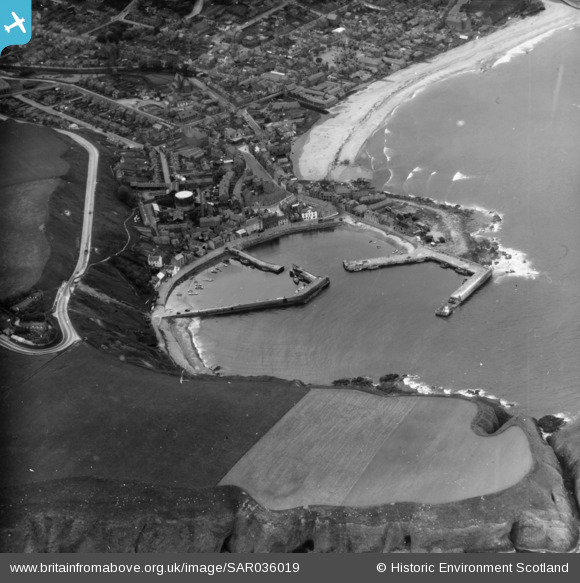
SAR036019 SCOTLAND (1959). General View Dunnottar, Kincardineshire, Scotland. An oblique aerial photograph taken facing North/West.
© Hawlfraint cyfranwyr OpenStreetMap a thrwyddedwyd gan yr OpenStreetMap Foundation. 2026. Trwyddedir y gartograffeg fel CC BY-SA.
Delweddau cyfagos (4)
SAR036019

SAR036020

SPW040486

SPW040485

Manylion
| Pennawd | [SAR036019] General View Dunnottar, Kincardineshire, Scotland. An oblique aerial photograph taken facing North/West. |
| Cyfeirnod | SAR036019 |
| Dyddiad | 1959 |
| Dolen | NRHE Collection item 1438657 |
| Enw lle | |
| Plwyf | FETTERESSO |
| Ardal | KINCARDINE AND DEESIDE |
| Gwlad | SCOTLAND |
| Dwyreiniad / Gogleddiad | 387290, 786000 |
| Hydred / Lledred | -2.2090509189935, 56.965215728761 |
| Cyfeirnod Grid Cenedlaethol | NO873860 |
Pinnau
Byddwch y cyntaf i ychwanegu sylw at y ddelwedd hon!
Cyfraniadau Grŵp
A misleading image title, as Dunnottar (and its ruined castle) is well out of frame to the south. This is a general view of the harbour, beach and town of Stonehaven. |

ewnmcg |
Tuesday 7th of October 2014 09:21:16 PM |