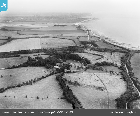
EPW062503 ENGLAND (1939). Bailiffscourt and the surrounding coastline, Climping, from the west, 1939
© Hawlfraint cyfranwyr OpenStreetMap a thrwyddedwyd gan yr OpenStreetMap Foundation. 2026. Trwyddedir y gartograffeg fel CC BY-SA.
Delweddau cyfagos (33)
Manylion
| Pennawd | [EPW062503] Bailiffscourt and the surrounding coastline, Climping, from the west, 1939 |
| Cyfeirnod | EPW062503 |
| Dyddiad | 13-August-1939 |
| Dolen | |
| Enw lle | CLIMPING |
| Plwyf | CLIMPING |
| Ardal | |
| Gwlad | ENGLAND |
| Dwyreiniad / Gogleddiad | 500016, 100793 |
| Hydred / Lledred | -0.58065702951668, 50.797493912601 |
| Cyfeirnod Grid Cenedlaethol | TQ000008 |


![[EPW062503] Bailiffscourt and the surrounding coastline, Climping, from the west, 1939](http://britainfromabove.org.uk/sites/all/libraries/aerofilms-images/public/100x100/EPW/062/EPW062503.jpg)
![[EPW020164] Bailiffscourt and surrounding countryside, Climping, 1927](http://britainfromabove.org.uk/sites/all/libraries/aerofilms-images/public/100x100/EPW/020/EPW020164.jpg)
![[EPW020167] Bailiffscourt and surrounding countryside, Climping, 1927](http://britainfromabove.org.uk/sites/all/libraries/aerofilms-images/public/100x100/EPW/020/EPW020167.jpg)
![[EPW020171] Bailiffscourt, Climping, 1927](http://britainfromabove.org.uk/sites/all/libraries/aerofilms-images/public/100x100/EPW/020/EPW020171.jpg)
![[EPW020169] Bailiffscourt and surrounding countryside, Climping, 1927](http://britainfromabove.org.uk/sites/all/libraries/aerofilms-images/public/100x100/EPW/020/EPW020169.jpg)
![[EPW020155] Bailiffscourt and surrounding countryside, Climping, 1927](http://britainfromabove.org.uk/sites/all/libraries/aerofilms-images/public/100x100/EPW/020/EPW020155.jpg)
![[EPW020163] Bailiffscourt and the sea, Climping, 1927](http://britainfromabove.org.uk/sites/all/libraries/aerofilms-images/public/100x100/EPW/020/EPW020163.jpg)
![[EPW020165] Bailiffscourt and surrounding countryside, Climping, 1927](http://britainfromabove.org.uk/sites/all/libraries/aerofilms-images/public/100x100/EPW/020/EPW020165.jpg)
![[EPW062498] Bailiffscourt and the surrounding countryside, Climping, 1939](http://britainfromabove.org.uk/sites/all/libraries/aerofilms-images/public/100x100/EPW/062/EPW062498.jpg)
![[EPW020160] Bailiffscourt and surrounding countryside, Climping, 1927](http://britainfromabove.org.uk/sites/all/libraries/aerofilms-images/public/100x100/EPW/020/EPW020160.jpg)
![[EPW062493] Bailiffscourt, Climping, from the north-west, 1939](http://britainfromabove.org.uk/sites/all/libraries/aerofilms-images/public/100x100/EPW/062/EPW062493.jpg)
![[EPW062497] Bailiffscourt and the surrounding countryside, Climping, 1939](http://britainfromabove.org.uk/sites/all/libraries/aerofilms-images/public/100x100/EPW/062/EPW062497.jpg)
![[EPW062495] Bailiffscourt, Climping, 1939](http://britainfromabove.org.uk/sites/all/libraries/aerofilms-images/public/100x100/EPW/062/EPW062495.jpg)
![[EPW062494] Bailiffscourt, Climping, 1939](http://britainfromabove.org.uk/sites/all/libraries/aerofilms-images/public/100x100/EPW/062/EPW062494.jpg)
![[EPW020153] Bailiffscourt, Climping, 1927](http://britainfromabove.org.uk/sites/all/libraries/aerofilms-images/public/100x100/EPW/020/EPW020153.jpg)
![[EPW045533] The beach, Bailiffscourt and surrounding countryside, Atherington, from the south, 1934. This image has been produced from a damaged negative.](http://britainfromabove.org.uk/sites/all/libraries/aerofilms-images/public/100x100/EPW/045/EPW045533.jpg)
![[EPW045538] Bailiffscourt and surrounding countryside, Atherington, 1934. This image has been produced from a damaged negative.](http://britainfromabove.org.uk/sites/all/libraries/aerofilms-images/public/100x100/EPW/045/EPW045538.jpg)
![[EPW020148] Bailiffscourt and surrounding countryside, Climping, 1927](http://britainfromabove.org.uk/sites/all/libraries/aerofilms-images/public/100x100/EPW/020/EPW020148.jpg)
![[EPW020149] Bailiffscourt and surrounding countryside, Climping, 1927](http://britainfromabove.org.uk/sites/all/libraries/aerofilms-images/public/100x100/EPW/020/EPW020149.jpg)
![[EPW020156] Bailiffscourt, Climping, 1927](http://britainfromabove.org.uk/sites/all/libraries/aerofilms-images/public/100x100/EPW/020/EPW020156.jpg)
![[EPW062492] Bailiffscourt, Climping, 1939](http://britainfromabove.org.uk/sites/all/libraries/aerofilms-images/public/100x100/EPW/062/EPW062492.jpg)
![[EPW020162] Bailiffscourt, Climping, 1927](http://britainfromabove.org.uk/sites/all/libraries/aerofilms-images/public/100x100/EPW/020/EPW020162.jpg)
![[EPW045535] The beach, Cudlow Barn, Bailiffscourt and surrounding countryside, Atherington, from the south-west, 1934. This image has been produced from a damaged negative.](http://britainfromabove.org.uk/sites/all/libraries/aerofilms-images/public/100x100/EPW/045/EPW045535.jpg)
![[EPW020150] Bailiffscourt, Climping, 1927](http://britainfromabove.org.uk/sites/all/libraries/aerofilms-images/public/100x100/EPW/020/EPW020150.jpg)
![[EPW020158] Bailiffscourt, Climping, 1927](http://britainfromabove.org.uk/sites/all/libraries/aerofilms-images/public/100x100/EPW/020/EPW020158.jpg)
![[EPW045536] Bailiffscourt, Atherington, 1934. This image has been produced from a damaged negative.](http://britainfromabove.org.uk/sites/all/libraries/aerofilms-images/public/100x100/EPW/045/EPW045536.jpg)
![[EPW020157] Bailiffscourt, Climping, 1927](http://britainfromabove.org.uk/sites/all/libraries/aerofilms-images/public/100x100/EPW/020/EPW020157.jpg)
![[EPW020151] Bailiffscourt, Climping, 1927](http://britainfromabove.org.uk/sites/all/libraries/aerofilms-images/public/100x100/EPW/020/EPW020151.jpg)
![[EPW020152] Bailiffscourt, Climping, 1927](http://britainfromabove.org.uk/sites/all/libraries/aerofilms-images/public/100x100/EPW/020/EPW020152.jpg)
![[EPW020172] Bailiffscourt, Climping, 1927](http://britainfromabove.org.uk/sites/all/libraries/aerofilms-images/public/100x100/EPW/020/EPW020172.jpg)
![[EPW020170] Bailiffscourt, Climping, 1927](http://britainfromabove.org.uk/sites/all/libraries/aerofilms-images/public/100x100/EPW/020/EPW020170.jpg)
![[EPW045583] Bailiffscourt and environs, Atherington, 1934. This image has been produced from a damaged negative.](http://britainfromabove.org.uk/sites/all/libraries/aerofilms-images/public/100x100/EPW/045/EPW045583.jpg)
![[EPW045537] Bailiffscourt and surrounding countryside, Atherington, 1934. This image has been produced from a damaged negative.](http://britainfromabove.org.uk/sites/all/libraries/aerofilms-images/public/100x100/EPW/045/EPW045537.jpg)
