
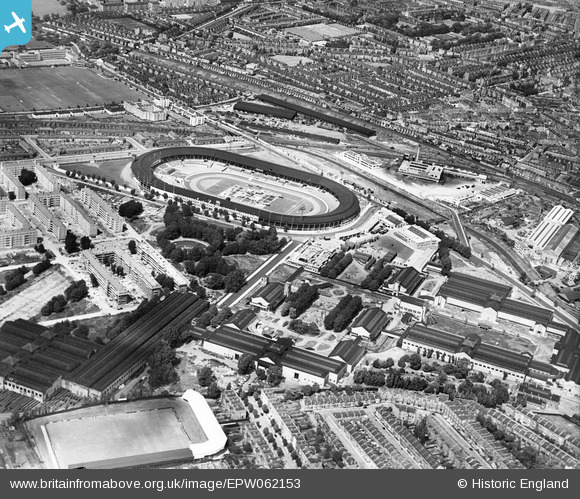
EPW062153 ENGLAND (1939). White City and the Olympic Stadium, Shepherd's Bush, 1939
© Hawlfraint cyfranwyr OpenStreetMap a thrwyddedwyd gan yr OpenStreetMap Foundation. 2026. Trwyddedir y gartograffeg fel CC BY-SA.
Delweddau cyfagos (48)
EPW062153

EPW022638

EPW042219
, 1933")
EPW031085

EPW053782

EPW053795

EPW056836

EPW022643

EPW031077

EPW021262

EPW022641

EPW036473

EPW019018

EPW054550

EPW022644

EPW031083

EPW031082

EPW053787

EPW046819

EPW054547

EPW031078

EPW005725

EPW022642

EPW031079

EAW005414

EPW042217
, 1933")
EPW036466

EPW054545

EPW021263

EPW042221
, 1933")
EPW036469

EPW022639

EPW042220
, 1933")
EPW054551

EPW036470

EPW036465

EPW036468

EPW054548

EPW036464

EPW031086

EPW031084

EPW054546

EPW031087

EPW054549

EPW042222
, 1933")
EPW042223
, 1933")
EPW031081

EAW005407

Manylion
| Pennawd | [EPW062153] White City and the Olympic Stadium, Shepherd's Bush, 1939 |
| Cyfeirnod | EPW062153 |
| Dyddiad | 9-July-1939 |
| Dolen | |
| Enw lle | SHEPHERD'S BUSH |
| Plwyf | |
| Ardal | |
| Gwlad | ENGLAND |
| Dwyreiniad / Gogleddiad | 523072, 180753 |
| Hydred / Lledred | -0.22626186385836, 51.511799581849 |
| Cyfeirnod Grid Cenedlaethol | TQ231808 |
Pinnau

douglasgray |
Thursday 25th of December 2025 02:28:05 AM | |
|
douglasgray |
Thursday 25th of December 2025 02:26:58 AM | |
|
douglasgray |
Thursday 25th of December 2025 02:25:51 AM | |
|
douglasgray |
Thursday 25th of December 2025 02:21:49 AM | |
|
douglasgray |
Thursday 25th of December 2025 02:20:16 AM | |
|
douglasgray |
Thursday 25th of December 2025 02:07:59 AM | |
|
douglasgray |
Thursday 25th of December 2025 02:05:49 AM | |
|
douglasgray |
Thursday 25th of December 2025 02:02:38 AM | |
|
Leslie B |
Monday 4th of July 2022 03:12:48 PM | |
|
Leslie B |
Monday 4th of July 2022 03:11:57 PM | |
|
Leslie B |
Monday 4th of July 2022 03:08:06 PM | |
|
Leslie B |
Monday 4th of July 2022 03:06:11 PM | |
|
Leslie B |
Monday 4th of July 2022 03:02:29 PM | |
|
Leslie B |
Monday 4th of July 2022 02:58:02 PM | |
|
Leslie B |
Monday 4th of July 2022 02:55:42 PM | |
 |
Leslie B |
Sunday 25th of July 2021 10:48:51 PM |
|
Karhedron |
Tuesday 3rd of May 2016 01:40:41 PM | |
|
Karhedron |
Tuesday 3rd of May 2016 01:40:08 PM | |
|
bondi |
Sunday 8th of November 2015 08:31:17 PM | |
|
bondi |
Sunday 8th of November 2015 08:15:54 PM | |
|
Bert |
Sunday 27th of October 2013 04:08:31 PM |