
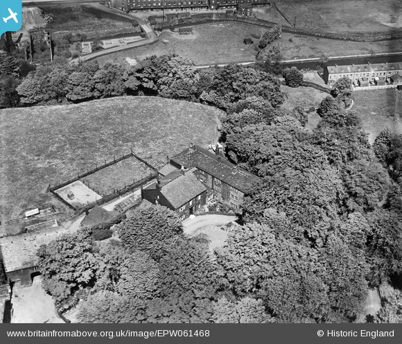
EPW061468 ENGLAND (1939). Stoodley Hall, Todmorden, 1939
© Hawlfraint cyfranwyr OpenStreetMap a thrwyddedwyd gan yr OpenStreetMap Foundation. 2026. Trwyddedir y gartograffeg fel CC BY-SA.
Delweddau cyfagos (4)
EPW061468

EAW052638

EAW052639

EAW052637

Manylion
| Pennawd | [EPW061468] Stoodley Hall, Todmorden, 1939 |
| Cyfeirnod | EPW061468 |
| Dyddiad | 4-June-1939 |
| Dolen | |
| Enw lle | TODMORDEN |
| Plwyf | TODMORDEN |
| Ardal | |
| Gwlad | ENGLAND |
| Dwyreiniad / Gogleddiad | 396492, 424951 |
| Hydred / Lledred | -2.0531667260676, 53.720732154018 |
| Cyfeirnod Grid Cenedlaethol | SD965250 |
Pinnau

Tim |
Saturday 1st of November 2014 08:26:49 PM | |
|
Tim |
Saturday 1st of November 2014 08:26:22 PM | |
|
Tim |
Saturday 1st of November 2014 08:25:48 PM | |
|
totoro |
Wednesday 25th of September 2013 05:08:30 PM | |
This is The Stoodley Hall and cottages not the Hunting Lodge. |
Tim |
Saturday 1st of November 2014 08:24:31 PM |
|
totoro |
Wednesday 25th of September 2013 05:04:39 PM | |
|
totoro |
Wednesday 25th of September 2013 05:02:41 PM | |
|
totoro |
Wednesday 25th of September 2013 05:02:24 PM |
Cyfraniadau Grŵp
Stoodley Hall dates back to around 1640 and has been in the same family since 1918 but does not seem to be in this image. Cellar windows are 17th C. It is a Grade 2 listed building, English Heritage Building ID: 405991. Post Code OL14 6HA. Latitude/Longitude: 53.7209, -2.0546 |
totoro |
Wednesday 25th of September 2013 05:18:26 PM |
Stoodley Hall Cottage is about 125 metres due East of the Hunting Lodge and is not in this image. |
totoro |
Wednesday 25th of September 2013 05:10:57 PM |