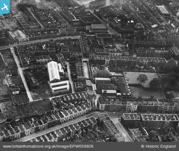
EPW059826 ENGLAND (1938). St Paul's National School, St Paul's Park and environs, Bristol, 1938
© Hawlfraint cyfranwyr OpenStreetMap a thrwyddedwyd gan yr OpenStreetMap Foundation. 2026. Trwyddedir y gartograffeg fel CC BY-SA.
Delweddau cyfagos (6)
Manylion
| Pennawd | [EPW059826] St Paul's National School, St Paul's Park and environs, Bristol, 1938 |
| Cyfeirnod | EPW059826 |
| Dyddiad | 1-October-1938 |
| Dolen | |
| Enw lle | BRISTOL |
| Plwyf | |
| Ardal | |
| Gwlad | ENGLAND |
| Dwyreiniad / Gogleddiad | 359626, 173787 |
| Hydred / Lledred | -2.5812148970545, 51.461128045957 |
| Cyfeirnod Grid Cenedlaethol | ST596738 |
Pinnau

MildBunch |
Wednesday 18th of February 2015 02:19:01 PM | |

MildBunch |
Wednesday 18th of February 2015 02:18:12 PM | |

Class31 |
Monday 10th of March 2014 04:26:08 PM | |

Class31 |
Monday 10th of March 2014 04:25:40 PM | |

Class31 |
Monday 10th of March 2014 04:24:33 PM | |

Class31 |
Monday 10th of March 2014 04:23:57 PM | |

Class31 |
Monday 10th of March 2014 04:23:05 PM | |

Class31 |
Monday 10th of March 2014 04:22:24 PM | |

Class31 |
Monday 10th of March 2014 04:22:00 PM | |

Class31 |
Monday 10th of March 2014 04:21:00 PM | |

Class31 |
Monday 10th of March 2014 04:16:50 PM | |

Class31 |
Monday 10th of March 2014 04:16:19 PM | |

Class31 |
Monday 10th of March 2014 04:15:57 PM |
Cyfraniadau Grŵp
View is looking south east. |

Class31 |
Monday 10th of March 2014 04:20:20 PM |


![[EPW059826] St Paul's National School, St Paul's Park and environs, Bristol, 1938](http://britainfromabove.org.uk/sites/all/libraries/aerofilms-images/public/100x100/EPW/059/EPW059826.jpg)
![[EPW059825] Wilson Place and environs, Bristol, 1938. This image has been produced from a print.](http://britainfromabove.org.uk/sites/all/libraries/aerofilms-images/public/100x100/EPW/059/EPW059825.jpg)
![[EPW059823] Wilson Place and environs, Bristol, 1938](http://britainfromabove.org.uk/sites/all/libraries/aerofilms-images/public/100x100/EPW/059/EPW059823.jpg)
![[EPW059827] St Paul's National School and environs, Bristol, 1938](http://britainfromabove.org.uk/sites/all/libraries/aerofilms-images/public/100x100/EPW/059/EPW059827.jpg)
![[EPW059828] St Paul's National School, St Paul's Park and environs, Bristol, 1938](http://britainfromabove.org.uk/sites/all/libraries/aerofilms-images/public/100x100/EPW/059/EPW059828.jpg)
![[EPW012228] Portland Square and St Paul's Church, Bristol, 1924. This image has been produced from a copy-negative.](http://britainfromabove.org.uk/sites/all/libraries/aerofilms-images/public/100x100/EPW/012/EPW012228.jpg)