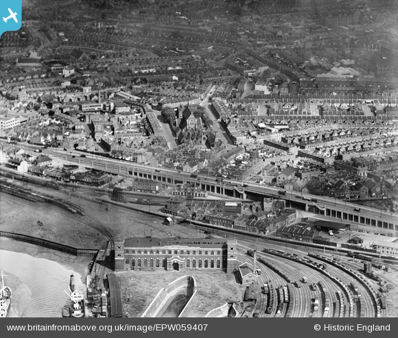
EPW059407 ENGLAND (1938). The Silvertown Way Viaduct, St Luke's Church and the surrounding residential area, Canning Town, 1938
    © Hawlfraint cyfranwyr OpenStreetMap a thrwyddedwyd gan yr OpenStreetMap Foundation. 2025. Trwyddedir y gartograffeg fel CC BY-SA.
  
Delweddau cyfagos (7)
Manylion
| Pennawd | [EPW059407] The Silvertown Way Viaduct, St Luke's Church and the surrounding residential area, Canning Town, 1938 | 
| Cyfeirnod | EPW059407 | 
| Dyddiad | 15-October-1938 | 
| Dolen | |
| Enw lle | CANNING TOWN | 
| Plwyf | |
| Ardal | |
| Gwlad | ENGLAND | 
| Dwyreiniad / Gogleddiad | 539777, 181003 | 
| Hydred / Lledred | 0.014442545390423, 51.510160170661 | 
| Cyfeirnod Grid Cenedlaethol | TQ398810 | 
Pinnau
|  Sidney Street |   Chris | Sunday 15th of August 2021 01:14:32 PM | 
|  Charlotte Street |   Chris | Sunday 15th of August 2021 01:14:00 PM | 
|  Sarah Street |   Chris | Sunday 15th of August 2021 01:13:35 PM | 
|  Catherine Street |   Chris | Sunday 15th of August 2021 01:13:15 PM | 
|  The office’s of the Thames Ironworks and Shipbuilding Company. Closed down in 1912 the premises appear derelict but have LNER signage in place. |   Grollo | Wednesday 9th of December 2020 06:32:38 AM | 
|  The Lord Nelson (Public House). Formerly sited at 117 Victoria Dock Road, but now long since demolished.
Apparently, the blues singer George Fame appeared here. |   Hermann the German | Wednesday 11th of October 2017 12:56:51 PM | 
|  Foot Bridge |   Hermann the German | Wednesday 11th of October 2017 12:49:56 PM | 
|  Boyd Road |   Hermann the German | Wednesday 11th of October 2017 12:43:45 PM | 
|  Saint Luke's Square |   Hermann the German | Wednesday 11th of October 2017 12:42:53 PM | 
|  Dry Dock |   Hermann the German | Wednesday 11th of October 2017 12:31:37 PM | 
| Class31 | Monday 16th of March 2015 02:36:04 PM | |
|  St Luke's Church, Canning Town |   sarahearney | Sunday 28th of July 2013 05:04:47 PM | 
 
             
  ![[EPW059407] The Silvertown Way Viaduct, St Luke's Church and the surrounding residential area, Canning Town, 1938](http://britainfromabove.org.uk/sites/all/libraries/aerofilms-images/public/100x100/EPW/059/EPW059407.jpg) 
  
                                          ![[EPW040854] Slum clearance off the Victoria Dock Road and environs, Canning Town, 1933](http://britainfromabove.org.uk/sites/all/libraries/aerofilms-images/public/100x100/EPW/040/EPW040854.jpg) 
 ![[EPW040853] Slum clearance off the Victoria Dock Road and environs, Canning Town, 1933](http://britainfromabove.org.uk/sites/all/libraries/aerofilms-images/public/100x100/EPW/040/EPW040853.jpg) 
 ![[EPW046798] A cityscape over the River Thames and the Isle of Dogs, Canning Town, from the north-east, 1935](http://britainfromabove.org.uk/sites/all/libraries/aerofilms-images/public/100x100/EPW/046/EPW046798.jpg) 
 ![[EPW059453] The Thames Wharf and environs, Canning Town, 1938](http://britainfromabove.org.uk/sites/all/libraries/aerofilms-images/public/100x100/EPW/059/EPW059453.jpg) 
 ![[EPW059455] Thames Wharf and the surrounding residential area, Canning Town, 1938](http://britainfromabove.org.uk/sites/all/libraries/aerofilms-images/public/100x100/EPW/059/EPW059455.jpg) 
 ![[EPW040852] Slum clearance off the Victoria Dock Road and environs, Canning Town, 1933](http://britainfromabove.org.uk/sites/all/libraries/aerofilms-images/public/100x100/EPW/040/EPW040852.jpg)