
EPW059073 ENGLAND (1938). Little Gregories, Piercing Hill, 1938

© Hawlfraint cyfranwyr OpenStreetMap a thrwyddedwyd gan yr OpenStreetMap Foundation. 2026. Trwyddedir y gartograffeg fel CC BY-SA.
Delweddau cyfagos (2)
EPW059073

EPW059074

Manylion
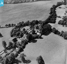
| Pennawd | [EPW059073] Little Gregories, Piercing Hill, 1938 |
| Cyfeirnod | EPW059073 |
| Dyddiad | 2-September-1938 |
| Dolen | |
| Enw lle | PIERCING HILL |
| Plwyf | THEYDON BOIS |
| Ardal | |
| Gwlad | ENGLAND |
| Dwyreiniad / Gogleddiad | 545138, 200079 |
| Hydred / Lledred | 0.099542100207022, 51.680231833447 |
| Cyfeirnod Grid Cenedlaethol | TL451001 |
Pinnau

Tony D |
Saturday 10th of August 2013 11:15:00 PM |
Cyfraniadau Grŵp
Pine Mount, or later Little Gregories, next to Theydon Bois Golf Course. View looking southwest. |
Tony D |
Tuesday 3rd of September 2013 04:31:05 PM |
Hi Tony D, Thanks for the location. We'll update the catalogue and post your new data here in due course. Yours, Katy Britain from Above Cataloguing Team Leader |
Katy Whitaker |
Tuesday 3rd of September 2013 04:31:05 PM |
Definitely Little Gregories |
BM |
Sunday 25th of August 2013 02:44:57 PM |
See also EPW059074. |
Tony D |
Saturday 10th of August 2013 11:17:04 PM |
Photo taken from East. Buildings seem to be on top of ridge, with ground sloping downwards to left of picture. |
BigglesH |
Monday 1st of July 2013 04:03:30 AM |
Probably Victorian |
Matthew Beckett - The Country Seat |
Sunday 16th of June 2013 10:42:17 PM |
Related to this image: http://www.britainfromabove.org.uk/image/epw059074 |
Matthew Beckett - The Country Seat |
Sunday 16th of June 2013 10:42:17 PM |