
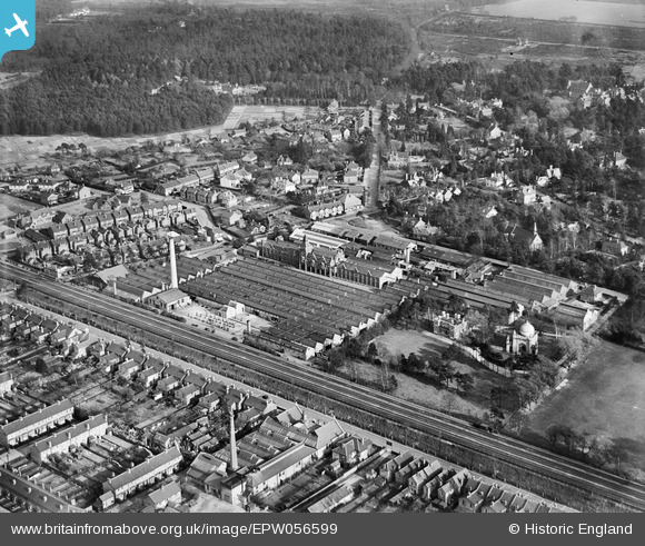
EPW056599 ENGLAND (1938). The Lion Packing Works, the Shah Jehan Mosque and the surrounding residential area, Woking, 1938
© Hawlfraint cyfranwyr OpenStreetMap a thrwyddedwyd gan yr OpenStreetMap Foundation. 2026. Trwyddedir y gartograffeg fel CC BY-SA.
Delweddau cyfagos (8)
EPW056599

EPW056603

EPW056600

EPW056596

EPW056601

EPW056598

EPW056597

EPW056602

Manylion
| Pennawd | [EPW056599] The Lion Packing Works, the Shah Jehan Mosque and the surrounding residential area, Woking, 1938 |
| Cyfeirnod | EPW056599 |
| Dyddiad | 25-March-1938 |
| Dolen | |
| Enw lle | WOKING |
| Plwyf | |
| Ardal | |
| Gwlad | ENGLAND |
| Dwyreiniad / Gogleddiad | 501646, 159243 |
| Hydred / Lledred | -0.54110790361097, 51.322693225685 |
| Cyfeirnod Grid Cenedlaethol | TQ016592 |
Pinnau

knightley |
Thursday 7th of November 2013 12:55:05 AM | |
|
knightley |
Thursday 7th of November 2013 12:53:43 AM | |
|
knightley |
Thursday 7th of November 2013 12:45:54 AM | |
|
Chris Willis |
Wednesday 12th of June 2013 11:38:27 PM | |
|
Chris Willis |
Wednesday 12th of June 2013 11:37:27 PM | |
|
Chris Willis |
Wednesday 12th of June 2013 11:36:46 PM | |
|
Chris Willis |
Wednesday 12th of June 2013 11:36:23 PM |
Cyfraniadau Grŵp
Similar to epw056597, epw056598, but higher. Clearer view of Mosque |
Chris Willis |
Wednesday 12th of June 2013 11:53:10 PM |