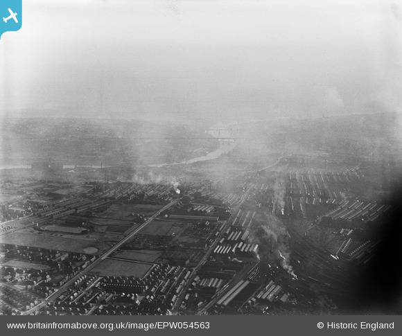
EPW054563 ENGLAND (1937). Heaton, Walker and Byker, Newcastle upon Tyne, from the north-east, 1937
© Hawlfraint cyfranwyr OpenStreetMap a thrwyddedwyd gan yr OpenStreetMap Foundation. 2026. Trwyddedir y gartograffeg fel CC BY-SA.
Delweddau cyfagos (17)
Manylion
| Pennawd | [EPW054563] Heaton, Walker and Byker, Newcastle upon Tyne, from the north-east, 1937 |
| Cyfeirnod | EPW054563 |
| Dyddiad | 30-July-1937 |
| Dolen | |
| Enw lle | NEWCASTLE UPON TYNE |
| Plwyf | |
| Ardal | |
| Gwlad | ENGLAND |
| Dwyreiniad / Gogleddiad | 427946, 565477 |
| Hydred / Lledred | -1.5632695236065, 54.983033520085 |
| Cyfeirnod Grid Cenedlaethol | NZ279655 |
Pinnau
Cyfraniadau Grŵp

Oldheaton |
Sunday 21st of July 2013 01:11:39 AM |


![[EPW054563] Heaton, Walker and Byker, Newcastle upon Tyne, from the north-east, 1937](http://britainfromabove.org.uk/sites/all/libraries/aerofilms-images/public/100x100/EPW/054/EPW054563.jpg)
![[EAW022482] C.A. Parsons and Co Heaton Heavy Electrical Plant Works and environs, Heaton, 1949. This image has been produced from a print marked by Aerofilms Ltd for photo editing.](http://britainfromabove.org.uk/sites/all/libraries/aerofilms-images/public/100x100/EAW/022/EAW022482.jpg)
![[EAW005493] Works off Shields Road including C.A. Parsons and Co Heaton Works, Heaton Junction and environs, Heaton, 1947](http://britainfromabove.org.uk/sites/all/libraries/aerofilms-images/public/100x100/EAW/005/EAW005493.jpg)
![[EAW022484] C.A. Parsons and Co Heaton Heavy Electrical Plant Works and environs, Heaton, 1949. This image has been produced from a print marked by Aerofilms Ltd for photo editing.](http://britainfromabove.org.uk/sites/all/libraries/aerofilms-images/public/100x100/EAW/022/EAW022484.jpg)
![[EPW059896] C.A. Parsons and Co Ltd Heaton Works and environs, Newcastle upon Tyne, 1938. This image has been produced from a print.](http://britainfromabove.org.uk/sites/all/libraries/aerofilms-images/public/100x100/EPW/059/EPW059896.jpg)
![[EPW042112] The C A Parsons and Co Heaton Works, Shields Road and environs, Heaton, 1933](http://britainfromabove.org.uk/sites/all/libraries/aerofilms-images/public/100x100/EPW/042/EPW042112.jpg)
![[EPW042113] The C A Parsons and Co Heaton Works, Shields Road and environs, Heaton, 1933](http://britainfromabove.org.uk/sites/all/libraries/aerofilms-images/public/100x100/EPW/042/EPW042113.jpg)
![[EAW006059] Shields Road and environs, Heaton, 1947](http://britainfromabove.org.uk/sites/all/libraries/aerofilms-images/public/100x100/EAW/006/EAW006059.jpg)
![[EAW005495] Works off Shields Road including C.A. Parsons and Co Heaton Works, Heaton, 1947](http://britainfromabove.org.uk/sites/all/libraries/aerofilms-images/public/100x100/EAW/005/EAW005495.jpg)
![[EAW005494] C.A. Parsons and Co Heaton Works and Heaton Junction, Heaton, 1947](http://britainfromabove.org.uk/sites/all/libraries/aerofilms-images/public/100x100/EAW/005/EAW005494.jpg)
![[EAW005497] Works off Shields Road including C.A. Parsons and Co Heaton Works, Heaton, 1947](http://britainfromabove.org.uk/sites/all/libraries/aerofilms-images/public/100x100/EAW/005/EAW005497.jpg)
![[EAW006058] The C. A. Parsons & Co Heaton Works and environs, Heaton, 1947. This image was marked by Aerofilms Ltd for photo editing.](http://britainfromabove.org.uk/sites/all/libraries/aerofilms-images/public/100x100/EAW/006/EAW006058.jpg)
![[EAW006057] The C. A. Parsons & Co Heaton Works and environs, Heaton, 1947](http://britainfromabove.org.uk/sites/all/libraries/aerofilms-images/public/100x100/EAW/006/EAW006057.jpg)
![[EPW059895] C.A. Parsons and Co Ltd Heaton Works and environs, Newcastle upon Tyne, 1938. This image has been produced from a print.](http://britainfromabove.org.uk/sites/all/libraries/aerofilms-images/public/100x100/EPW/059/EPW059895.jpg)
![[EAW005496] Works off Shields Road including C.A. Parsons and Co Heaton Works, Heaton, 1947](http://britainfromabove.org.uk/sites/all/libraries/aerofilms-images/public/100x100/EAW/005/EAW005496.jpg)
![[EPW042114] The C A Parsons and Co Heaton Works, Shields Road and environs, Heaton, 1933](http://britainfromabove.org.uk/sites/all/libraries/aerofilms-images/public/100x100/EPW/042/EPW042114.jpg)
![[EAW006056] The C. A. Parsons & Co Heaton Works and environs, Heaton, 1947. This image was marked by Aerofilms Ltd for photo editing.](http://britainfromabove.org.uk/sites/all/libraries/aerofilms-images/public/100x100/EAW/006/EAW006056.jpg)
