
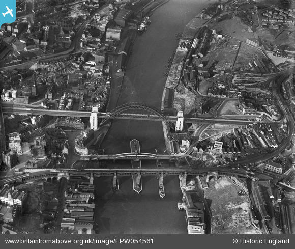
EPW054561 ENGLAND (1937). The Tyne Bridge, Newcastle Swing Bridge and the High Level Bridge, Newcastle upon Tyne, 1937
© Hawlfraint cyfranwyr OpenStreetMap a thrwyddedwyd gan yr OpenStreetMap Foundation. 2026. Trwyddedir y gartograffeg fel CC BY-SA.
Delweddau cyfagos (22)
EPW025016

EPW054561

EPW020568

EPW048345

EPW048229

EPW054559

EPW019820

EPW020570

EPW048805

EPW048346

EPW048235

EPW020569

EPW025015

EPW048799

EPW048263

EPW048230

EPW010393

EPW048800

EPW048803

EAW405203

EPW019832

EPW051090

Manylion
| Pennawd | [EPW054561] The Tyne Bridge, Newcastle Swing Bridge and the High Level Bridge, Newcastle upon Tyne, 1937 |
| Cyfeirnod | EPW054561 |
| Dyddiad | 30-July-1937 |
| Dolen | |
| Enw lle | NEWCASTLE UPON TYNE |
| Plwyf | |
| Ardal | |
| Gwlad | ENGLAND |
| Dwyreiniad / Gogleddiad | 425317, 563782 |
| Hydred / Lledred | -1.604503215436, 54.96794104349 |
| Cyfeirnod Grid Cenedlaethol | NZ253638 |
Pinnau

Chells809 |
Thursday 16th of February 2017 08:27:55 PM | |
|
Chells809 |
Thursday 16th of February 2017 08:27:12 PM | |
|
Chells809 |
Thursday 16th of February 2017 08:26:29 PM | |
|
Chells809 |
Thursday 16th of February 2017 08:25:48 PM | |
|
Chells809 |
Thursday 16th of February 2017 08:24:53 PM | |
|
Chells809 |
Thursday 16th of February 2017 08:23:27 PM | |
|
Chells809 |
Thursday 16th of February 2017 08:22:29 PM | |
|
Chells809 |
Thursday 16th of February 2017 08:21:25 PM | |
|
Chells809 |
Thursday 16th of February 2017 08:20:37 PM | |
|
Chells809 |
Thursday 16th of February 2017 08:19:58 PM | |
|
Chells809 |
Thursday 16th of February 2017 08:18:41 PM | |
|
history group |
Wednesday 12th of June 2013 08:17:51 PM | |
|
history group |
Wednesday 12th of June 2013 08:16:01 PM | |
|
history group |
Wednesday 12th of June 2013 08:14:54 PM |
Cyfraniadau Grŵp
Here is an audio of the image's description below, produced by blind and partially sighted users of Sight Service Gateshead during a partnership project with Britain from Above. Speaker is Dr Dorothy Hamilton, project lead. |
Sandra Brauer |
Wednesday 28th of August 2013 11:40:52 AM |
This photograph shows three bridges over the River Tyne in 1937. On the right hand side of the picture is Gateshead. On the left hand side of the picture is Newcastle. The bridge which is nearest the bottom of the picture is the High Level Bridge, which opened in 1849 to carry a railway track across the river. It also carries a road for pedestrians and vehicles below the railway line. The middle bridge on the picture is the Swing Bridge, built between 1868 and 1876, to allow larger ships to pass down the river to Armstrong's works in Elswick. The bridge replaced the previous bridge which was built in Georgian times. It is in the same place as the medieval Tyne Bridge, and is probably where the Roman bridge crossed the Tyne. The bridge nearer the middle of the picture is the Tyne Bridge. It has a very distinctive semi-circular shape. It was built in 1928 to link Pilgrim Street to the High Street in Gateshead. Bensham Group |
history group |
Wednesday 12th of June 2013 08:27:12 PM |