
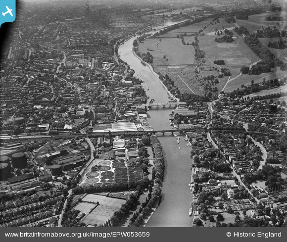
EPW053659 ENGLAND (1937). The River Thames and environs at Kingston Bridge, Kingston Upon Thames, from the north, 1937
© Hawlfraint cyfranwyr OpenStreetMap a thrwyddedwyd gan yr OpenStreetMap Foundation. 2026. Trwyddedir y gartograffeg fel CC BY-SA.
Delweddau cyfagos (10)
EPW053659

EAW019822

EAW019815

EAW019820

EAW019821

EAW019817

EAW042762

EAW022048

EPW001726

EAW042766

Manylion
| Pennawd | [EPW053659] The River Thames and environs at Kingston Bridge, Kingston Upon Thames, from the north, 1937 |
| Cyfeirnod | EPW053659 |
| Dyddiad | 12-June-1937 |
| Dolen | |
| Enw lle | KINGSTON UPON THAMES |
| Plwyf | |
| Ardal | |
| Gwlad | ENGLAND |
| Dwyreiniad / Gogleddiad | 517818, 169670 |
| Hydred / Lledred | -0.3056412175583, 51.413298984937 |
| Cyfeirnod Grid Cenedlaethol | TQ178697 |
Pinnau

Leslie B |
Tuesday 8th of March 2016 01:11:25 PM | |
|
Pip |
Thursday 2nd of January 2014 02:59:39 PM | |
|
Pip |
Thursday 2nd of January 2014 02:58:46 PM | |
|
Pip |
Thursday 2nd of January 2014 02:58:03 PM | |
|
Pip |
Thursday 2nd of January 2014 02:56:48 PM | |
|
Pip |
Thursday 2nd of January 2014 02:55:47 PM | |
|
Pip |
Thursday 2nd of January 2014 12:48:13 AM | |
|
Pip |
Thursday 2nd of January 2014 12:47:46 AM | |
|
Pip |
Thursday 2nd of January 2014 12:47:03 AM | |
|
Pip |
Thursday 2nd of January 2014 12:45:19 AM | |
|
Pip |
Thursday 2nd of January 2014 12:44:56 AM |
Cyfraniadau Grŵp
Kingston Bridge |

Alan McFaden |
Sunday 9th of November 2014 01:42:42 PM |

Kingston upon Thames |
Alan McFaden |
Sunday 9th of November 2014 01:42:18 PM |