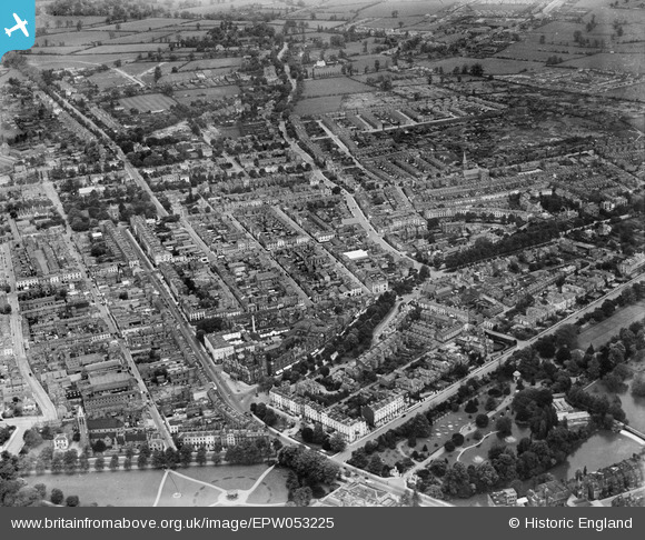
EPW053225 ENGLAND (1937). The town, Royal Leamington Spa, from the south-west, 1937
© Hawlfraint cyfranwyr OpenStreetMap a thrwyddedwyd gan yr OpenStreetMap Foundation. 2026. Trwyddedir y gartograffeg fel CC BY-SA.
Delweddau cyfagos (17)
Manylion
| Pennawd | [EPW053225] The town, Royal Leamington Spa, from the south-west, 1937 |
| Cyfeirnod | EPW053225 |
| Dyddiad | 24-May-1937 |
| Dolen | |
| Enw lle | ROYAL LEAMINGTON SPA |
| Plwyf | ROYAL LEAMINGTON SPA |
| Ardal | |
| Gwlad | ENGLAND |
| Dwyreiniad / Gogleddiad | 431863, 265754 |
| Hydred / Lledred | -1.5328104686338, 52.288605302074 |
| Cyfeirnod Grid Cenedlaethol | SP319658 |
Pinnau

Glassman |
Tuesday 8th of April 2014 04:37:51 PM | |

Glassman |
Tuesday 8th of April 2014 04:37:08 PM | |

Glassman |
Tuesday 8th of April 2014 04:34:42 PM | |

Glassman |
Tuesday 8th of April 2014 02:56:00 PM |


![[EPW053225] The town, Royal Leamington Spa, from the south-west, 1937](http://britainfromabove.org.uk/sites/all/libraries/aerofilms-images/public/100x100/EPW/053/EPW053225.jpg)
![[EPW001214] Leamington Spa Pump Room Gardens, and the Town Hall, Royal Leamington Spa, 1920](http://britainfromabove.org.uk/sites/all/libraries/aerofilms-images/public/100x100/EPW/001/EPW001214.jpg)
![[EPW005093] The town centre including the Pump Room Gardens, Royal Leamington Spa, 1920](http://britainfromabove.org.uk/sites/all/libraries/aerofilms-images/public/100x100/EPW/005/EPW005093.jpg)
![[EPW005096] The Parade and environs including the Pump Room Gardens, Royal Leamington Spa, 1920](http://britainfromabove.org.uk/sites/all/libraries/aerofilms-images/public/100x100/EPW/005/EPW005096.jpg)
![[EPW005091] The town centre including the Pump Room Gardens and All Saints Church, Royal Leamington Spa, 1920](http://britainfromabove.org.uk/sites/all/libraries/aerofilms-images/public/100x100/EPW/005/EPW005091.jpg)
![[EPW001219] The Town Centre, Royal Leamington Spa, 1920](http://britainfromabove.org.uk/sites/all/libraries/aerofilms-images/public/100x100/EPW/001/EPW001219.jpg)
![[EAW003636] The town centre, Royal Leamington Spa, from the south-east, 1947](http://britainfromabove.org.uk/sites/all/libraries/aerofilms-images/public/100x100/EAW/003/EAW003636.jpg)
![[EPW005097] The Parade and environs, Royal Leamington Spa, 1920](http://britainfromabove.org.uk/sites/all/libraries/aerofilms-images/public/100x100/EPW/005/EPW005097.jpg)
![[EPW053222] Regent Street and environs, Royal Leamington Spa, 1937](http://britainfromabove.org.uk/sites/all/libraries/aerofilms-images/public/100x100/EPW/053/EPW053222.jpg)
![[EAW003637] The town centre, Royal Leamington Spa, from the south-east, 1947](http://britainfromabove.org.uk/sites/all/libraries/aerofilms-images/public/100x100/EAW/003/EAW003637.jpg)
![[EPW005092] The Parade and environs, Royal Leamington Spa, 1920](http://britainfromabove.org.uk/sites/all/libraries/aerofilms-images/public/100x100/EPW/005/EPW005092.jpg)
![[EPW053226] Jephson Gardens and the south-eastern area of the town, Royal Leamington Spa, from the north-west, 1937](http://britainfromabove.org.uk/sites/all/libraries/aerofilms-images/public/100x100/EPW/053/EPW053226.jpg)
![[EPW001215] Jephson Gardens area, Royal Leamington Spa, 1920](http://britainfromabove.org.uk/sites/all/libraries/aerofilms-images/public/100x100/EPW/001/EPW001215.jpg)
![[EPW005095] The Parade and environs, Royal Leamington Spa, 1920](http://britainfromabove.org.uk/sites/all/libraries/aerofilms-images/public/100x100/EPW/005/EPW005095.jpg)
![[EAW024685] The Pump Room Gardens, All Saints' Church and the town centre, Royal Leamington Spa, from the south-east, 1949](http://britainfromabove.org.uk/sites/all/libraries/aerofilms-images/public/100x100/EAW/024/EAW024685.jpg)
![[EAW024683] The Pump Room Gardens and the town centre, Royal Leamington Spa, 1949](http://britainfromabove.org.uk/sites/all/libraries/aerofilms-images/public/100x100/EAW/024/EAW024683.jpg)
![[EPW053219] Jephson Gardens and All Saints' Church, Royal Leamington Spa, 1937](http://britainfromabove.org.uk/sites/all/libraries/aerofilms-images/public/100x100/EPW/053/EPW053219.jpg)
