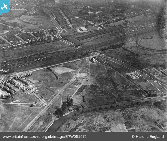
EPW051672 ENGLAND (1936). Brent Junction and environs, Alperton, 1936
© Hawlfraint cyfranwyr OpenStreetMap a thrwyddedwyd gan yr OpenStreetMap Foundation. 2026. Trwyddedir y gartograffeg fel CC BY-SA.
Delweddau cyfagos (23)
Manylion
| Pennawd | [EPW051672] Brent Junction and environs, Alperton, 1936 |
| Cyfeirnod | EPW051672 |
| Dyddiad | August-1936 |
| Dolen | |
| Enw lle | ALPERTON |
| Plwyf | |
| Ardal | |
| Gwlad | ENGLAND |
| Dwyreiniad / Gogleddiad | 519386, 183902 |
| Hydred / Lledred | -0.27829155178422, 51.540895117463 |
| Cyfeirnod Grid Cenedlaethol | TQ194839 |
Pinnau

Nowy Paul |
Saturday 6th of January 2018 03:27:19 PM | |

bondi |
Thursday 29th of October 2015 09:33:06 PM | |

greenchief |
Monday 13th of January 2014 03:31:39 PM | |

greenchief |
Monday 13th of January 2014 03:26:32 PM | |

greenchief |
Monday 13th of January 2014 03:24:46 PM | |

csunderland |
Thursday 16th of May 2013 01:36:37 AM | |

csunderland |
Thursday 16th of May 2013 01:35:51 AM | |

csunderland |
Thursday 16th of May 2013 01:30:37 AM | |

csunderland |
Thursday 16th of May 2013 01:30:05 AM | |

csunderland |
Thursday 16th of May 2013 01:23:40 AM | |

csunderland |
Thursday 16th of May 2013 01:20:23 AM | |

csunderland |
Thursday 16th of May 2013 01:19:51 AM |


![[EPW051672] Brent Junction and environs, Alperton, 1936](http://britainfromabove.org.uk/sites/all/libraries/aerofilms-images/public/100x100/EPW/051/EPW051672.jpg)
![[EPW052467] The offices of Aerofilms Ltd and surrounding works and housing under construction off Beresford Avenue, Alperton, 1937. This image has been produced from a print.](http://britainfromabove.org.uk/sites/all/libraries/aerofilms-images/public/100x100/EPW/052/EPW052467.jpg)
![[EPW056366] Aerofilms Ltd Premises on Beresford Avenue, Alperton, 1938](http://britainfromabove.org.uk/sites/all/libraries/aerofilms-images/public/100x100/EPW/056/EPW056366.jpg)
![[EPW056467] The offices of Aerofilms Ltd on Beresford Avenue, Alperton, 1938](http://britainfromabove.org.uk/sites/all/libraries/aerofilms-images/public/100x100/EPW/056/EPW056467.jpg)
![[EPW056468] The offices of Aerofilms Ltd on Beresford Avenue, Alperton, 1938](http://britainfromabove.org.uk/sites/all/libraries/aerofilms-images/public/100x100/EPW/056/EPW056468.jpg)
![[EPW052465] The offices of Aerofilms Ltd on Beresford Avenue, Alperton, 1937. This image has been produced from a print.](http://britainfromabove.org.uk/sites/all/libraries/aerofilms-images/public/100x100/EPW/052/EPW052465.jpg)
![[EPW051679] Brent Junction, construction of Beresford Avenue and housing at Kenmere Gardens, Alperton, 1936](http://britainfromabove.org.uk/sites/all/libraries/aerofilms-images/public/100x100/EPW/051/EPW051679.jpg)
![[EPW056469] The Rizla Ltd factory on Beresford Avenue, Alperton, 1938](http://britainfromabove.org.uk/sites/all/libraries/aerofilms-images/public/100x100/EPW/056/EPW056469.jpg)
![[EPW053022] Construction of housing and industrial buildings along Beresford Avenue and Brent Junction, Alperton, 1937](http://britainfromabove.org.uk/sites/all/libraries/aerofilms-images/public/100x100/EPW/053/EPW053022.jpg)
![[EPW053017] Construction of housing and industrial buildings along Beresford Avenue and environs, Alperton, 1937](http://britainfromabove.org.uk/sites/all/libraries/aerofilms-images/public/100x100/EPW/053/EPW053017.jpg)
![[EPW056470] The Rizla Ltd factory on Beresford Avenue, Alperton, 1938](http://britainfromabove.org.uk/sites/all/libraries/aerofilms-images/public/100x100/EPW/056/EPW056470.jpg)
![[EPW051676] Construction of Beresford Avenue and housing at Kenmere Gardens, Alperton, 1936](http://britainfromabove.org.uk/sites/all/libraries/aerofilms-images/public/100x100/EPW/051/EPW051676.jpg)
![[EPW053018] Construction of housing and industrial buildings along Beresford Avenue and environs, Alperton, 1937](http://britainfromabove.org.uk/sites/all/libraries/aerofilms-images/public/100x100/EPW/053/EPW053018.jpg)
![[EPW051675] Brent Junction, construction of Beresford Avenue and housing at Kenmere Gardens, Alperton, 1936](http://britainfromabove.org.uk/sites/all/libraries/aerofilms-images/public/100x100/EPW/051/EPW051675.jpg)
![[EPW051677] Construction of Beresford Avenue and housing at Kenmere Gardens and environs, Alperton, 1936](http://britainfromabove.org.uk/sites/all/libraries/aerofilms-images/public/100x100/EPW/051/EPW051677.jpg)
![[EPW053021] Construction of housing and industrial buildings along Beresford Avenue, Alperton, 1937](http://britainfromabove.org.uk/sites/all/libraries/aerofilms-images/public/100x100/EPW/053/EPW053021.jpg)
![[EPW051678] Construction of Beresford Avenue and housing at Kenmere Gardens and environs, Alperton, 1936](http://britainfromabove.org.uk/sites/all/libraries/aerofilms-images/public/100x100/EPW/051/EPW051678.jpg)
![[EPW051674] Construction of Beresford Avenue and housing at Kenmere Gardens and environs, Alperton, 1936](http://britainfromabove.org.uk/sites/all/libraries/aerofilms-images/public/100x100/EPW/051/EPW051674.jpg)
![[EPW053019] The Grand Union Canal, construction of housing and industrial buildings along Beresford Avenue and environs, Alperton, 1937](http://britainfromabove.org.uk/sites/all/libraries/aerofilms-images/public/100x100/EPW/053/EPW053019.jpg)
![[EPW053016] Construction of housing and industrial buildings along Beresford Avenue, Alperton, 1937](http://britainfromabove.org.uk/sites/all/libraries/aerofilms-images/public/100x100/EPW/053/EPW053016.jpg)
![[EPW051680] Brent Junction, construction of Beresford Avenue and environs, Alperton, 1936](http://britainfromabove.org.uk/sites/all/libraries/aerofilms-images/public/100x100/EPW/051/EPW051680.jpg)
![[EPW056086] The Celotex Works under construction, Alperton, 1937. This image has been produced from a damaged negative.](http://britainfromabove.org.uk/sites/all/libraries/aerofilms-images/public/100x100/EPW/056/EPW056086.jpg)
![[EPW056464] The Celotex Ltd factory and environs at Stonebridge Park, Alperton, 1938](http://britainfromabove.org.uk/sites/all/libraries/aerofilms-images/public/100x100/EPW/056/EPW056464.jpg)