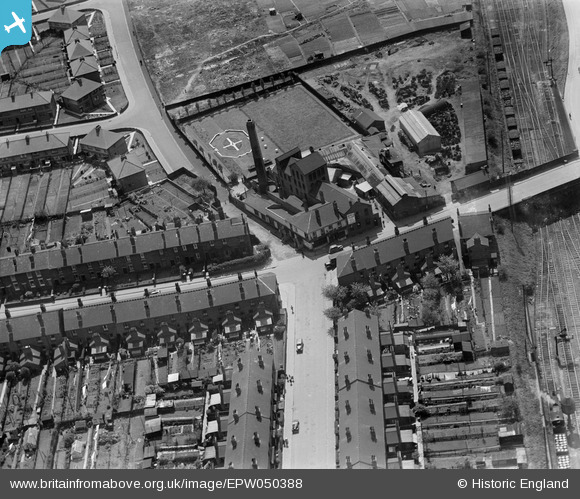
EPW050388 ENGLAND (1936). Cremalt Ltd at Albion Mills, Oldbury, 1936
    © Hawlfraint cyfranwyr OpenStreetMap a thrwyddedwyd gan yr OpenStreetMap Foundation. 2025. Trwyddedir y gartograffeg fel CC BY-SA.
  
Delweddau cyfagos (14)
Manylion
| Pennawd | [EPW050388] Cremalt Ltd at Albion Mills, Oldbury, 1936 | 
| Cyfeirnod | EPW050388 | 
| Dyddiad | July-1936 | 
| Dolen | |
| Enw lle | OLDBURY | 
| Plwyf | |
| Ardal | |
| Gwlad | ENGLAND | 
| Dwyreiniad / Gogleddiad | 399905, 288564 | 
| Hydred / Lledred | -2.0013994290285, 52.494617265442 | 
| Cyfeirnod Grid Cenedlaethol | SO999886 | 
Pinnau
|  Cottage Spring Pub |   Piper | Saturday 29th of February 2020 02:43:35 PM | 
 
             
  ![[EPW050388] Cremalt Ltd at Albion Mills, Oldbury, 1936](http://britainfromabove.org.uk/sites/all/libraries/aerofilms-images/public/100x100/EPW/050/EPW050388.jpg) 
  
                                          ![[EPW050389] Cremalt Ltd at Albion Mills, Oldbury, 1936](http://britainfromabove.org.uk/sites/all/libraries/aerofilms-images/public/100x100/EPW/050/EPW050389.jpg) 
 ![[EPW050392] Cremalt Ltd at Albion Mills, Oldbury, 1936](http://britainfromabove.org.uk/sites/all/libraries/aerofilms-images/public/100x100/EPW/050/EPW050392.jpg) 
 ![[EPW050390] Cremalt Ltd at Albion Mills, Oldbury, 1936](http://britainfromabove.org.uk/sites/all/libraries/aerofilms-images/public/100x100/EPW/050/EPW050390.jpg) 
 ![[EPW050391] Cremalt Ltd at Albion Mills, Oldbury, 1936](http://britainfromabove.org.uk/sites/all/libraries/aerofilms-images/public/100x100/EPW/050/EPW050391.jpg) 
 ![[EPW050393] Cremalt Ltd at Albion Mills, Oldbury, 1936](http://britainfromabove.org.uk/sites/all/libraries/aerofilms-images/public/100x100/EPW/050/EPW050393.jpg) 
 ![[EAW001206] The industrial and residential area surrounding Tat Bank Road and Mushroom Hall Road, Rood End, 1946](http://britainfromabove.org.uk/sites/all/libraries/aerofilms-images/public/100x100/EAW/001/EAW001206.jpg) 
 ![[EAW001207] The industrial and residential area surrounding Tat Bank Road and Apollo Road, Rood End, 1946](http://britainfromabove.org.uk/sites/all/libraries/aerofilms-images/public/100x100/EAW/001/EAW001207.jpg) 
 ![[EAW021491] The Cox and Danks Ltd Scapa Works and environs, Oldbury, from the south-west, 1949. This image has been produced from a print marked by Aerofilms Ltd for photo editing.](http://britainfromabove.org.uk/sites/all/libraries/aerofilms-images/public/100x100/EAW/021/EAW021491.jpg) 
 ![[EAW021490] The Cox and Danks Ltd Scapa Works and environs, Oldbury, 1949. This image has been produced from a print marked by Aerofilms Ltd for photo editing.](http://britainfromabove.org.uk/sites/all/libraries/aerofilms-images/public/100x100/EAW/021/EAW021490.jpg) 
 ![[EAW021489] The Cox and Danks Ltd Scapa Works and environs, Oldbury, from the south-west, 1949. This image has been produced from a print marked by Aerofilms Ltd for photo editing.](http://britainfromabove.org.uk/sites/all/libraries/aerofilms-images/public/100x100/EAW/021/EAW021489.jpg) 
 ![[EAW001208] The industrial and residential area surrounding Tat Bank Road, Apollo Road and Wellesley Road, Rood End, 1946](http://britainfromabove.org.uk/sites/all/libraries/aerofilms-images/public/100x100/EAW/001/EAW001208.jpg) 
 ![[EAW021487] The Cox and Danks Ltd Works off Tatbank Road, Oldbury, 1949. This image has been produced from a print marked by Aerofilms Ltd for photo editing.](http://britainfromabove.org.uk/sites/all/libraries/aerofilms-images/public/100x100/EAW/021/EAW021487.jpg) 
 ![[EAW001210] The Credenda Electrical Engineering Works and the surrounding industrial and residential area, Rood End, 1946](http://britainfromabove.org.uk/sites/all/libraries/aerofilms-images/public/100x100/EAW/001/EAW001210.jpg)