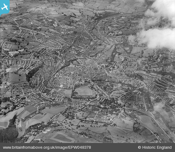
EPW048378 ENGLAND (1935). The city, Bath, from the north-east, 1935
    © Hawlfraint cyfranwyr OpenStreetMap a thrwyddedwyd gan yr OpenStreetMap Foundation. 2025. Trwyddedir y gartograffeg fel CC BY-SA.
  
Delweddau cyfagos (5)
Manylion
| Pennawd | [EPW048378] The city, Bath, from the north-east, 1935 | 
| Cyfeirnod | EPW048378 | 
| Dyddiad | July-1935 | 
| Dolen | |
| Enw lle | BATH | 
| Plwyf | |
| Ardal | |
| Gwlad | ENGLAND | 
| Dwyreiniad / Gogleddiad | 375845, 164955 | 
| Hydred / Lledred | -2.3471338370441, 51.382631449421 | 
| Cyfeirnod Grid Cenedlaethol | ST758650 | 
Pinnau
|  First Avenue | Class31 | Saturday 18th of May 2013 08:15:11 PM | 
 
             
  ![[EPW048378] The city, Bath, from the north-east, 1935](http://britainfromabove.org.uk/sites/all/libraries/aerofilms-images/public/100x100/EPW/048/EPW048378.jpg) 
  
                                          ![[EPW048379] The city, Bath, from the east, 1935](http://britainfromabove.org.uk/sites/all/libraries/aerofilms-images/public/100x100/EPW/048/EPW048379.jpg) 
 ![[EPW001937] Raby Place and environs, Bath, 1920](http://britainfromabove.org.uk/sites/all/libraries/aerofilms-images/public/100x100/EPW/001/EPW001937.jpg) 
 ![[EAW023883] The city, Bath, from the east, 1949. This image has been produced from a print.](http://britainfromabove.org.uk/sites/all/libraries/aerofilms-images/public/100x100/EAW/023/EAW023883.jpg) 
 ![[EPW001955] The Holburne Museum and environs, Bath, 1920](http://britainfromabove.org.uk/sites/all/libraries/aerofilms-images/public/100x100/EPW/001/EPW001955.jpg)