
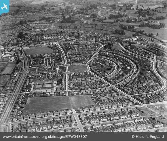
EPW048307 ENGLAND (1935). The residential estate at Knowle Park, Knowle, 1935
© Hawlfraint cyfranwyr OpenStreetMap a thrwyddedwyd gan yr OpenStreetMap Foundation. 2026. Trwyddedir y gartograffeg fel CC BY-SA.
Delweddau cyfagos (2)
EPW048307

EPW048306

Manylion
| Pennawd | [EPW048307] The residential estate at Knowle Park, Knowle, 1935 |
| Cyfeirnod | EPW048307 |
| Dyddiad | July-1935 |
| Dolen | |
| Enw lle | KNOWLE |
| Plwyf | |
| Ardal | |
| Gwlad | ENGLAND |
| Dwyreiniad / Gogleddiad | 360453, 170350 |
| Hydred / Lledred | -2.5689260330992, 51.430280441848 |
| Cyfeirnod Grid Cenedlaethol | ST605704 |
Pinnau

John Swain |
Tuesday 16th of May 2017 11:46:26 AM | |
|
John Swain |
Monday 15th of May 2017 11:20:14 AM | |
|
John Swain |
Monday 15th of May 2017 10:05:19 AM | |
|
John Swain |
Monday 15th of May 2017 10:00:34 AM | |
|
John Swain |
Monday 15th of May 2017 09:51:37 AM | |
|
John Swain |
Monday 15th of May 2017 09:50:32 AM | |
|
John Swain |
Monday 15th of May 2017 09:43:39 AM | |
|
John Swain |
Monday 15th of May 2017 09:42:42 AM | |
|
John Swain |
Monday 15th of May 2017 09:42:08 AM | |
|
John Swain |
Monday 15th of May 2017 09:41:02 AM | |
|
John Swain |
Monday 15th of May 2017 09:38:54 AM | |
|
John Swain |
Monday 15th of May 2017 09:38:05 AM | |
|
John Swain |
Monday 15th of May 2017 09:35:20 AM | |
|
John Swain |
Monday 15th of May 2017 09:34:33 AM | |
|
John Swain |
Monday 15th of May 2017 09:33:12 AM | |
|
John Swain |
Monday 15th of May 2017 09:31:50 AM | |
|
John Swain |
Monday 15th of May 2017 09:29:09 AM | |
|
John Swain |
Monday 15th of May 2017 09:26:44 AM | |
|
John Swain |
Monday 15th of May 2017 09:25:52 AM | |

Geoff |
Tuesday 5th of August 2014 02:27:20 PM | |

Class31 |
Wednesday 26th of February 2014 08:28:05 PM | |
|
Class31 |
Wednesday 26th of February 2014 08:27:45 PM | |
|
Class31 |
Wednesday 26th of February 2014 08:27:27 PM | |
|
Class31 |
Wednesday 26th of February 2014 08:26:50 PM | |
|
Class31 |
Wednesday 26th of February 2014 08:26:24 PM | |
|
Class31 |
Wednesday 26th of February 2014 08:25:47 PM | |
|
Class31 |
Wednesday 26th of February 2014 08:24:41 PM | |
|
Class31 |
Wednesday 26th of February 2014 08:24:11 PM | |
|
adfbristol |
Thursday 20th of June 2013 11:46:35 AM | |
|
adfbristol |
Thursday 20th of June 2013 11:45:51 AM | |
Do you know the name of the church? Durbandeep. |
Durbandeep |
Monday 22nd of July 2013 10:50:17 AM |
|
adfbristol |
Thursday 20th of June 2013 11:45:09 AM |
Cyfraniadau Grŵp
The interwar council housing estate at Knowle Park (Knowle West)was part of a massive development in the 1930s to the west of the Wells Road, which saw the construction of 6,000 homes for 27,000 people in both Knowle and Bedminster. The standard of the housing was high and was based upon the popular Garden Suburb movement of the time. Many of the folk housed in the above image had been relocated from the inner city slums of Bristol. The writer lived in lodgings in Woodbridge Road (late Edwardian street, circa 1914), Knowle, for nine months from October 1962, during his first year as an undergraduate at Bristol University and thus parts of this area became familiar. |
John Swain |
Monday 15th of May 2017 10:15:38 AM |
View looking east. |
Class31 |
Wednesday 26th of February 2014 08:25:11 PM |