
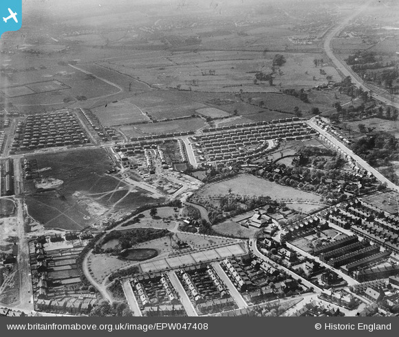
EPW047408 ENGLAND (1935). Light Oaks Park, housing under construction along Burnside Avenue and environs, Salford, from the east, 1935
© Hawlfraint cyfranwyr OpenStreetMap a thrwyddedwyd gan yr OpenStreetMap Foundation. 2026. Trwyddedir y gartograffeg fel CC BY-SA.
Delweddau cyfagos (6)
EPW047408

EPW047403

EPW047406

EPW047407

EPW047411

EPW047404

Manylion
| Pennawd | [EPW047408] Light Oaks Park, housing under construction along Burnside Avenue and environs, Salford, from the east, 1935 |
| Cyfeirnod | EPW047408 |
| Dyddiad | May-1935 |
| Dolen | |
| Enw lle | SALFORD |
| Plwyf | |
| Ardal | |
| Gwlad | ENGLAND |
| Dwyreiniad / Gogleddiad | 379230, 400169 |
| Hydred / Lledred | -2.3131321340985, 53.497561072136 |
| Cyfeirnod Grid Cenedlaethol | SD792002 |
Pinnau

Lizzie |
Tuesday 3rd of October 2023 08:26:32 PM | |
|
Lizzie |
Tuesday 3rd of October 2023 08:24:57 PM | |
|
Lizzie |
Tuesday 3rd of October 2023 08:00:33 PM | |
|
Lizzie |
Tuesday 3rd of October 2023 08:00:05 PM | |
|
Lizzie |
Tuesday 3rd of October 2023 07:59:07 PM | |
|
Lizzie |
Tuesday 3rd of October 2023 07:46:58 PM | |

JW |
Thursday 20th of November 2014 11:21:09 PM | |
|
JW |
Thursday 20th of November 2014 11:20:22 PM | |
|
JW |
Thursday 20th of November 2014 11:19:01 PM |