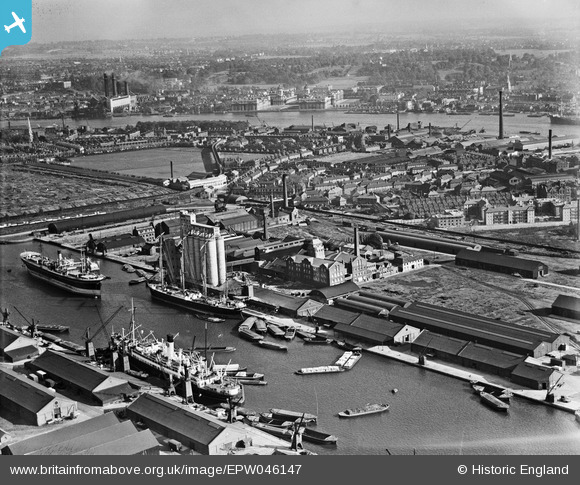
EPW046147 ENGLAND (1934). Millwall Docks, Cubitt Town and environs, Isle of Dogs, from the north-west, 1934
© Hawlfraint cyfranwyr OpenStreetMap a thrwyddedwyd gan yr OpenStreetMap Foundation. 2026. Trwyddedir y gartograffeg fel CC BY-SA.
Delweddau cyfagos (18)
Manylion
| Pennawd | [EPW046147] Millwall Docks, Cubitt Town and environs, Isle of Dogs, from the north-west, 1934 |
| Cyfeirnod | EPW046147 |
| Dyddiad | September-1934 |
| Dolen | |
| Enw lle | ISLE OF DOGS |
| Plwyf | |
| Ardal | |
| Gwlad | ENGLAND |
| Dwyreiniad / Gogleddiad | 537549, 178987 |
| Hydred / Lledred | -0.018432403185631, 51.49258899517 |
| Cyfeirnod Grid Cenedlaethol | TQ375790 |
Pinnau

bushwhackers |
Thursday 27th of October 2016 08:10:40 PM | |

moses72 |
Wednesday 28th of August 2013 07:45:05 PM |


![[EPW046147] Millwall Docks, Cubitt Town and environs, Isle of Dogs, from the north-west, 1934](http://britainfromabove.org.uk/sites/all/libraries/aerofilms-images/public/100x100/EPW/046/EPW046147.jpg)
![[EPW046146] Millwall Docks and environs, Isle of Dogs, from the north, 1934](http://britainfromabove.org.uk/sites/all/libraries/aerofilms-images/public/100x100/EPW/046/EPW046146.jpg)
![[EAW011757] McDougalls Limited Wheatsheaf Flour Mills and Millwall Outer Dock, Millwall, 1947](http://britainfromabove.org.uk/sites/all/libraries/aerofilms-images/public/100x100/EAW/011/EAW011757.jpg)
![[EAW011755] McDougalls Limited Wheatsheaf Flour Mills, Millwall, 1947](http://britainfromabove.org.uk/sites/all/libraries/aerofilms-images/public/100x100/EAW/011/EAW011755.jpg)
![[EPW060548] Millwall Outer Dock, Millwall, 1939](http://britainfromabove.org.uk/sites/all/libraries/aerofilms-images/public/100x100/EPW/060/EPW060548.jpg)
![[EAW011759] McDougalls Limited Wheatsheaf Flour Mills, Millwall, 1947](http://britainfromabove.org.uk/sites/all/libraries/aerofilms-images/public/100x100/EAW/011/EAW011759.jpg)
![[EPW046145] Millwall Docks and environs, Isle of Dogs, from the north, 1934](http://britainfromabove.org.uk/sites/all/libraries/aerofilms-images/public/100x100/EPW/046/EPW046145.jpg)
![[EAW011753] McDougalls Limited Wheatsheaf Flour Mills, Millwall, 1947](http://britainfromabove.org.uk/sites/all/libraries/aerofilms-images/public/100x100/EAW/011/EAW011753.jpg)
![[EAW011752] McDougalls Limited Wheatsheaf Flour Mills, Millwall, 1947](http://britainfromabove.org.uk/sites/all/libraries/aerofilms-images/public/100x100/EAW/011/EAW011752.jpg)
![[EAW011754] McDougalls Limited Wheatsheaf Flour Mills and environs, Millwall, 1947](http://britainfromabove.org.uk/sites/all/libraries/aerofilms-images/public/100x100/EAW/011/EAW011754.jpg)
![[EPW044130] West India Docks, Millwall Docks and environs, Isle of Dogs, from the south-west, 1934](http://britainfromabove.org.uk/sites/all/libraries/aerofilms-images/public/100x100/EPW/044/EPW044130.jpg)
![[EAW011756] McDougalls Limited Wheatsheaf Flour Mills, Millwall, 1947](http://britainfromabove.org.uk/sites/all/libraries/aerofilms-images/public/100x100/EAW/011/EAW011756.jpg)
![[EPW044131] West India Docks, Millwall Docks and environs, Isle of Dogs, from the south, 1934](http://britainfromabove.org.uk/sites/all/libraries/aerofilms-images/public/100x100/EPW/044/EPW044131.jpg)
![[EPW046149] The Telegraph and India Rubber Works and environs, Isle of Dogs, from the west, 1934](http://britainfromabove.org.uk/sites/all/libraries/aerofilms-images/public/100x100/EPW/046/EPW046149.jpg)
![[EPW046148] Millwall Docks, Cubitt Town and environs, Isle of Dogs, 1934](http://britainfromabove.org.uk/sites/all/libraries/aerofilms-images/public/100x100/EPW/046/EPW046148.jpg)
![[EAW011758] McDougalls Limited Wheatsheaf Flour Mills, Millwall, 1947](http://britainfromabove.org.uk/sites/all/libraries/aerofilms-images/public/100x100/EAW/011/EAW011758.jpg)
![[EPW060455] The West India and Millwall Docks and the surrounding industrial area, Isle of Dogs, 1939](http://britainfromabove.org.uk/sites/all/libraries/aerofilms-images/public/100x100/EPW/060/EPW060455.jpg)
![[EAW009803] The West India Docks and Millwall Dock, Isle of Dogs, 1947](http://britainfromabove.org.uk/sites/all/libraries/aerofilms-images/public/100x100/EAW/009/EAW009803.jpg)