
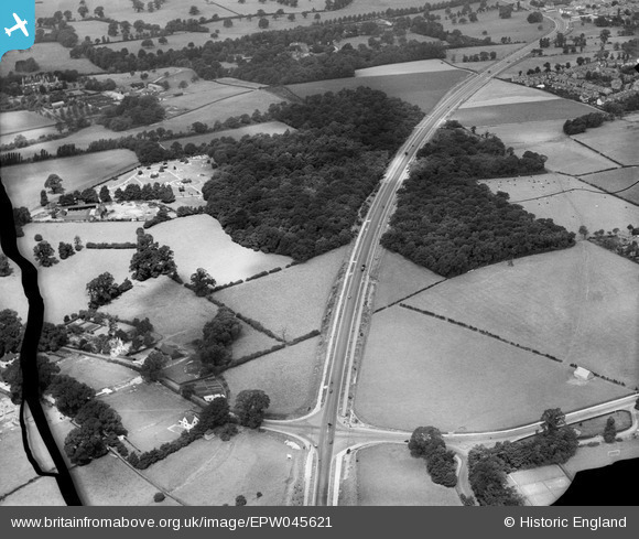
EPW045621 ENGLAND (1934). The Sidcup By Pass Road (A20) cutting through Beaver's Wood, Chislehurst, 1934. This image has been produced from a damaged negative.
© Hawlfraint cyfranwyr OpenStreetMap a thrwyddedwyd gan yr OpenStreetMap Foundation. 2026. Trwyddedir y gartograffeg fel CC BY-SA.
Delweddau cyfagos (3)
EPW045621
 cutting through Beaver's Wood, Chislehurst, 1934. This image has been produced from a damaged negative.")
EPW045618
 cutting through Beaver's Wood and Scadbury Park, Chislehurst, 1934. This image has been produced from a damaged negative.")
EPW045620
 cutting through Beaver's Wood and Scadbury Park, Chislehurst, 1934. This image has been produced from a damaged negative.")
Manylion
| Pennawd | [EPW045621] The Sidcup By Pass Road (A20) cutting through Beaver's Wood, Chislehurst, 1934. This image has been produced from a damaged negative. |
| Cyfeirnod | EPW045621 |
| Dyddiad | July-1934 |
| Dolen | |
| Enw lle | CHISLEHURST |
| Plwyf | |
| Ardal | |
| Gwlad | ENGLAND |
| Dwyreiniad / Gogleddiad | 545674, 171147 |
| Hydred / Lledred | 0.095306954783742, 51.420099173242 |
| Cyfeirnod Grid Cenedlaethol | TQ457711 |
Pinnau

R_Wilson |
Tuesday 19th of December 2023 10:52:23 AM | |
|
Gone2Kent |
Tuesday 13th of May 2014 08:24:15 PM | |
 |
Gone2Kent |
Tuesday 13th of May 2014 08:22:22 PM |
