
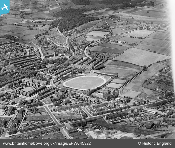
EPW045322 ENGLAND (1934). The Fartown Cricket and Football Grounds and surrounding residential area, Huddersfield, 1934
© Hawlfraint cyfranwyr OpenStreetMap a thrwyddedwyd gan yr OpenStreetMap Foundation. 2026. Trwyddedir y gartograffeg fel CC BY-SA.
Delweddau cyfagos (4)
EPW045322

EPW054251

EPW026514

EPW045318

Manylion
| Pennawd | [EPW045322] The Fartown Cricket and Football Grounds and surrounding residential area, Huddersfield, 1934 |
| Cyfeirnod | EPW045322 |
| Dyddiad | July-1934 |
| Dolen | |
| Enw lle | HUDDERSFIELD |
| Plwyf | |
| Ardal | |
| Gwlad | ENGLAND |
| Dwyreiniad / Gogleddiad | 414229, 418482 |
| Hydred / Lledred | -1.7846451407693, 53.662399352725 |
| Cyfeirnod Grid Cenedlaethol | SE142185 |
Pinnau

RT |
Friday 22nd of April 2022 01:25:50 PM | |
|
RT |
Friday 22nd of April 2022 11:41:51 AM | |
|
RT |
Friday 22nd of April 2022 11:34:36 AM | |
|
Stan |
Sunday 7th of December 2014 04:26:08 PM | |
|
Stan |
Sunday 7th of December 2014 04:25:09 PM | |
|
Stan |
Sunday 7th of December 2014 04:24:13 PM | |
|
Stan |
Sunday 7th of December 2014 04:23:38 PM | |
|
Stan |
Sunday 7th of December 2014 04:19:19 PM | |
|
Stan |
Sunday 7th of December 2014 04:18:29 PM | |
|
Stan |
Sunday 7th of December 2014 04:14:10 PM | |
|
Stan |
Saturday 5th of April 2014 05:09:45 PM | |
|
Stan |
Saturday 5th of April 2014 05:08:16 PM | |
|
Stan |
Saturday 5th of April 2014 05:05:10 PM |
Cyfraniadau Grŵp
H&AC Bowling Green this is the larger of the two greens |
Stan |
Sunday 7th of December 2014 04:15:15 PM |