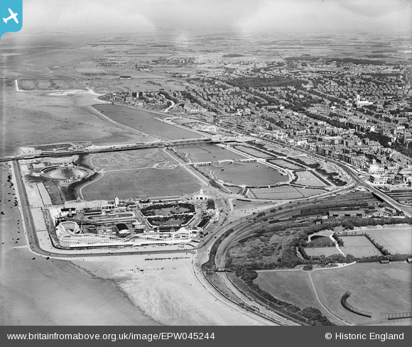
EPW045244 ENGLAND (1934). Princes Park and the seafront, Southport, from the south-west, 1934
© Hawlfraint cyfranwyr OpenStreetMap a thrwyddedwyd gan yr OpenStreetMap Foundation. 2026. Trwyddedir y gartograffeg fel CC BY-SA.
Delweddau cyfagos (14)
Manylion
| Pennawd | [EPW045244] Princes Park and the seafront, Southport, from the south-west, 1934 |
| Cyfeirnod | EPW045244 |
| Dyddiad | July-1934 |
| Dolen | |
| Enw lle | SOUTHPORT |
| Plwyf | |
| Ardal | |
| Gwlad | ENGLAND |
| Dwyreiniad / Gogleddiad | 332779, 417280 |
| Hydred / Lledred | -3.0170405551076, 53.647468410327 |
| Cyfeirnod Grid Cenedlaethol | SD328173 |
Pinnau

Andrew |
Thursday 13th of August 2015 09:38:25 PM | |

John Wass |
Saturday 9th of May 2015 02:15:12 PM | |

morris minor |
Thursday 7th of August 2014 08:50:06 PM | |

Bryan |
Thursday 8th of May 2014 08:44:43 PM | |

Bryan |
Thursday 8th of May 2014 08:43:07 PM | |

Bryan |
Thursday 8th of May 2014 08:42:28 PM | |

Bryan |
Thursday 8th of May 2014 08:41:12 PM |


![[EPW045244] Princes Park and the seafront, Southport, from the south-west, 1934](http://britainfromabove.org.uk/sites/all/libraries/aerofilms-images/public/100x100/EPW/045/EPW045244.jpg)
![[EPW058497] Pleasureland, Southport, 1938](http://britainfromabove.org.uk/sites/all/libraries/aerofilms-images/public/100x100/EPW/058/EPW058497.jpg)
![[EPW045243] Pleasureland and Princes Park, Southport, 1934](http://britainfromabove.org.uk/sites/all/libraries/aerofilms-images/public/100x100/EPW/045/EPW045243.jpg)
![[EPW045246] Victoria Park, Princes Park and environs, Southport, from the south-west, 1934](http://britainfromabove.org.uk/sites/all/libraries/aerofilms-images/public/100x100/EPW/045/EPW045246.jpg)
![[EPW020363] Pleasureland, Southport, 1928](http://britainfromabove.org.uk/sites/all/libraries/aerofilms-images/public/100x100/EPW/020/EPW020363.jpg)
![[EPW020364] Pleasureland, Southport, 1928](http://britainfromabove.org.uk/sites/all/libraries/aerofilms-images/public/100x100/EPW/020/EPW020364.jpg)
![[EAW010136] Southport, the Flower Show in Victoria Park, 1947. This image was marked by Aerofilms Ltd for photo editing.](http://britainfromabove.org.uk/sites/all/libraries/aerofilms-images/public/100x100/EAW/010/EAW010136.jpg)
![[EPW020365] Pleasureland, Southport, 1928](http://britainfromabove.org.uk/sites/all/libraries/aerofilms-images/public/100x100/EPW/020/EPW020365.jpg)
![[EPW013091] Pleasureland, Southport, 1925. This image has been produced from a copy-negative.](http://britainfromabove.org.uk/sites/all/libraries/aerofilms-images/public/100x100/EPW/013/EPW013091.jpg)
![[EPW018657] Southport, crowds gathered for the total solar eclipse, 1927](http://britainfromabove.org.uk/sites/all/libraries/aerofilms-images/public/100x100/EPW/018/EPW018657.jpg)
![[EAW038522] Pleasureland, Southport, 1951. This image has been produced from a print.](http://britainfromabove.org.uk/sites/all/libraries/aerofilms-images/public/100x100/EAW/038/EAW038522.jpg)
![[EAW010137] Southport, the Flower Show in Victoria Park, 1947. This image was marked by Aerofilms Ltd for photo editing.](http://britainfromabove.org.uk/sites/all/libraries/aerofilms-images/public/100x100/EAW/010/EAW010137.jpg)
![[EAW038520] Pleasureland and the surrounding area, Southport, 1951. This image has been produced from a print.](http://britainfromabove.org.uk/sites/all/libraries/aerofilms-images/public/100x100/EAW/038/EAW038520.jpg)
![[EAW010135] Southport, the Flower Show in Victoria Park, 1947. This image was marked by Aerofilms Ltd for photo editing.](http://britainfromabove.org.uk/sites/all/libraries/aerofilms-images/public/100x100/EAW/010/EAW010135.jpg)