
EPW043815 ENGLAND (1934). High Spen village, Miller's Wood and the Garesfield and Chopwell Railway, High Spen, from the south-east, 1934

© Hawlfraint cyfranwyr OpenStreetMap a thrwyddedwyd gan yr OpenStreetMap Foundation. 2026. Trwyddedir y gartograffeg fel CC BY-SA.
Manylion
| Pennawd | [EPW043815] High Spen village, Miller's Wood and the Garesfield and Chopwell Railway, High Spen, from the south-east, 1934 |
| Cyfeirnod | EPW043815 |
| Dyddiad | February-1934 |
| Dolen | |
| Enw lle | HIGH SPEN |
| Plwyf | |
| Ardal | |
| Gwlad | ENGLAND |
| Dwyreiniad / Gogleddiad | 413862, 559604 |
| Hydred / Lledred | -1.7836505330547, 54.930842643385 |
| Cyfeirnod Grid Cenedlaethol | NZ139596 |
Pinnau

RayU |
Thursday 16th of April 2026 03:43:35 PM | |
|
RayU |
Thursday 16th of April 2026 03:42:34 PM | |
|
RayU |
Thursday 16th of April 2026 03:41:13 PM | |
|
RayU |
Thursday 16th of April 2026 03:40:46 PM | |
|
RayU |
Thursday 16th of April 2026 03:38:58 PM | |
|
RayU |
Thursday 16th of April 2026 03:38:25 PM | |
|
RayU |
Thursday 16th of April 2026 03:37:48 PM | |
|
RayU |
Thursday 16th of April 2026 03:36:51 PM | |
|
RayU |
Wednesday 15th of April 2026 10:26:10 AM | |
|
RayU |
Wednesday 15th of April 2026 10:25:24 AM | |
|
Pamela Smith |
Sunday 4th of February 2024 08:56:54 AM | |
|
Pamela Smith |
Sunday 4th of February 2024 08:50:49 AM | |
|
Pamela Smith |
Sunday 4th of February 2024 08:46:25 AM | |
|
Pamela Smith |
Sunday 4th of February 2024 08:37:27 AM | |
|
Pamela Smith |
Sunday 4th of February 2024 08:31:25 AM | |
|
Pamela Smith |
Sunday 4th of February 2024 08:22:56 AM | |
|
Norman Fay |
Tuesday 4th of April 2023 09:13:48 PM | |
|
J May |
Friday 5th of March 2021 07:06:08 PM | |
|
J May |
Friday 5th of March 2021 07:05:21 PM | |
|
J May |
Friday 5th of March 2021 07:04:26 PM | |
|
J May |
Friday 5th of March 2021 07:01:48 PM | |
|
J May |
Friday 5th of March 2021 07:01:16 PM | |
|
history group |
Wednesday 12th of June 2013 09:14:43 PM | |
|
history group |
Wednesday 12th of June 2013 09:12:34 PM |
Cyfraniadau Grŵp
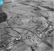
The description of this image has been produced by the group. To listen to an audio of this description as well as some of the participants' personal memories inspired by the image, watch the video below. High Spen was a mining village. The colliery can be seen on the right hand side of the picture, close to where the railway lines cross the road. There are gantries taking coal from one part of the colliery to another. Very close to the colliery are the rows of colliery housing. In High Spen, most of the houses have gardens. On the edge of the village, behind the main road, there are some new inter-war houses and bungalows. In the centre of the picture is a football ground. On the right of the picture a circular garden feature is part of High Spen Park. The village was in a very rural location, which is why it was classified as Category D, in 1951. This meant that no further investment was to be made in the village, and the population would eventually be re-housed elsewhere, closer to amenities and new jobs. But, along with many other Category D villages, High Spen is here today. |
Sandra Brauer |
Monday 9th of September 2013 04:01:50 PM |
Here is an audio of a description of the image, produced by blind and partially sighted users of Sight Service Gateshead during a partnership project with Britain from Above. Speaker is Dr Dorothy Hamilton, project lead. |
Sandra Brauer |
Friday 30th of August 2013 11:10:51 AM |
High Spen was a mining village. The colliery can be seen on the right hand side of the picture, close to where the railway lines cross the road. There are gantries taking coal from one part of the colliery to another. Very close to the colliery are the rows of colliery housing. In High Spen, most of the houses have gardens. On the edge of the village, behind the main road, there are some new inter-war houses and bungalows. In the centre of the picture is a football ground. On the right of the picture a circular garden feature is part of High Spen Park. The village was in a very rural location, which is why it was classified as Category D, in 1951. This meant that no further investment was to be made in the village, and the population would eventually be re-housed elsewhere, closer to amenities and new jobs. But, along with many other Category D villages, High Spen is here today. Bensham Group |
history group |
Wednesday 12th of June 2013 09:09:04 PM |