
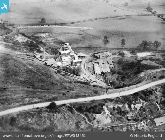
EPW043451 ENGLAND (1933). The Hartshill Quarries, Hartshill, 1933
© Hawlfraint cyfranwyr OpenStreetMap a thrwyddedwyd gan yr OpenStreetMap Foundation. 2025. Trwyddedir y gartograffeg fel CC BY-SA.
Delweddau cyfagos (11)
EPW043451

EPW043455

EPW043449

EPW043450

EPW043454

EPW043453

EPW042886

EPW042882

EPW043452

EPW042885

EPW042884

Manylion
| Pennawd | [EPW043451] The Hartshill Quarries, Hartshill, 1933 |
| Cyfeirnod | EPW043451 |
| Dyddiad | October-1933 |
| Dolen | |
| Enw lle | HARTSHILL |
| Plwyf | HARTSHILL |
| Ardal | |
| Gwlad | ENGLAND |
| Dwyreiniad / Gogleddiad | 433399, 294314 |
| Hydred / Lledred | -1.507436974474, 52.545290551137 |
| Cyfeirnod Grid Cenedlaethol | SP334943 |
Pinnau
Byddwch y cyntaf i ychwanegu sylw at y ddelwedd hon!
Cyfraniadau Grŵp
Hi There, I worked next door at the Man Abel quarry during the early sixties, my father Albert Finch was the Manager when Judkins took over the operation. I currently live in South Africa and have made numerous visits to the area over the past two years obtaining as much data of the Jee's site as possible. I am currently planning to build a model railway incorporating the quarry, canal loading facility and the main line siding. The information available on this web site is of great value to me, however, if anyone can supply further detailed photo's of the quarry process plant, the canal loading facility and the main line loading facility they would be greatly appreciated. My contact is - John Finch - johnkate@me.com. |

John Finch |
Sunday 18th of August 2013 05:04:31 PM |