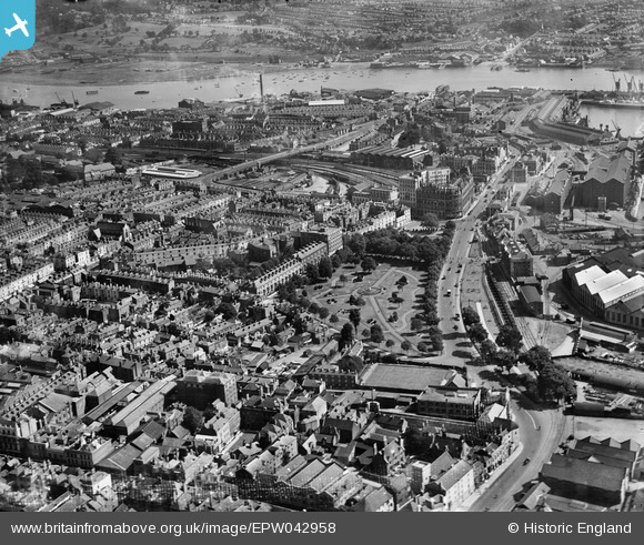
EPW042958 ENGLAND (1933). Queen's Park, the Town and Dock Railway Station and environs, Southampton, 1933
    © Hawlfraint cyfranwyr OpenStreetMap a thrwyddedwyd gan yr OpenStreetMap Foundation. 2025. Trwyddedir y gartograffeg fel CC BY-SA.
  
Delweddau cyfagos (6)
Manylion
| Pennawd | [EPW042958] Queen's Park, the Town and Dock Railway Station and environs, Southampton, 1933 | 
| Cyfeirnod | EPW042958 | 
| Dyddiad | August-1933 | 
| Dolen | |
| Enw lle | SOUTHAMPTON | 
| Plwyf | |
| Ardal | |
| Gwlad | ENGLAND | 
| Dwyreiniad / Gogleddiad | 442334, 111096 | 
| Hydred / Lledred | -1.3979591071292, 50.897236123557 | 
| Cyfeirnod Grid Cenedlaethol | SU423111 | 
Pinnau
|  John Street |   cabbagecaff | Sunday 21st of July 2024 06:41:09 PM | 
|  Ocean Village |   jkm | Friday 21st of January 2022 01:10:15 PM | 
|  Gloucester Square |   jkm | Friday 21st of January 2022 01:04:08 PM | 
|  God's House Hospital / Hospital of St. Julian |   jkm | Friday 21st of January 2022 01:03:38 PM | 
|  God's House Tower and Old Town Walls |   jkm | Friday 21st of January 2022 01:02:11 PM | 
|  Brunswick Square |   jkm | Friday 21st of January 2022 01:00:56 PM | 
|  Southampton Old Bowling Green , Southampton 29/05/2014 There is said to have been a bowling green on this site since 1299! | Class31 | Thursday 29th of May 2014 07:54:07 PM | 
| Class31 | Thursday 29th of May 2014 07:52:45 PM | |
|  Southampton Terminus Station building which is Grade II listed and designed by Sir William Tite. Photographed 5th August 2013. | Class31 | Monday 5th of August 2013 10:55:05 PM | 
|  Bernard Street at junction with 
Threefield Lane looking north west. Photo taken 5th August 2013. | Class31 | Monday 5th of August 2013 10:41:41 PM | 
|  Bernard Street looking south east along Oxford Street. Photo taken 5th August 2013. | Class31 | Monday 5th of August 2013 10:38:51 PM | 
| Class31 | Monday 5th of August 2013 10:25:33 PM | 
 
             
  ![[EPW042958] Queen's Park, the Town and Dock Railway Station and environs, Southampton, 1933](http://britainfromabove.org.uk/sites/all/libraries/aerofilms-images/public/100x100/EPW/042/EPW042958.jpg) 
  
                                          ![[EPW009077] The Inner Dock and Queen's Park area, Southampton, 1923](http://britainfromabove.org.uk/sites/all/libraries/aerofilms-images/public/100x100/EPW/009/EPW009077.jpg) 
 ![[EPW001504] Inner Dock, the Railway Station, Queen's Park and environs, Southampton, 1920. This image has been produced from a copy-negative.](http://britainfromabove.org.uk/sites/all/libraries/aerofilms-images/public/100x100/EPW/001/EPW001504.jpg) 
 ![[EPW041064] Ocean Dock, the RMS Mauretania in the floating dry dock and environs, Southampton, from the north-west, 1933](http://britainfromabove.org.uk/sites/all/libraries/aerofilms-images/public/100x100/EPW/041/EPW041064.jpg) 
 ![[EAW008801] Harland & Wolff Ltd Shipbuilding and Engineering Works, Southampton, 1947](http://britainfromabove.org.uk/sites/all/libraries/aerofilms-images/public/100x100/EAW/008/EAW008801.jpg) 
 ![[EPW039727] Reclamation of the Western Docks between Royal Pier and Millbrook Point, Southampton, from the south-east, 1932](http://britainfromabove.org.uk/sites/all/libraries/aerofilms-images/public/100x100/EPW/039/EPW039727.jpg) 


