
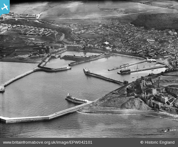
EPW042101 ENGLAND (1933). Whitehaven Harbour and environs, Whitehaven, 1933
© Hawlfraint cyfranwyr OpenStreetMap a thrwyddedwyd gan yr OpenStreetMap Foundation. 2026. Trwyddedir y gartograffeg fel CC BY-SA.
Delweddau cyfagos (3)
EPW042101

EPW042098

EPW042102

Manylion
| Pennawd | [EPW042101] Whitehaven Harbour and environs, Whitehaven, 1933 |
| Cyfeirnod | EPW042101 |
| Dyddiad | June-1933 |
| Dolen | |
| Enw lle | WHITEHAVEN |
| Plwyf | |
| Ardal | |
| Gwlad | ENGLAND |
| Dwyreiniad / Gogleddiad | 297069, 518421 |
| Hydred / Lledred | -3.5915653439026, 54.550430572743 |
| Cyfeirnod Grid Cenedlaethol | NX971184 |
Pinnau

Buchan |
Saturday 25th of October 2025 08:25:00 PM | |
|
Buchan |
Saturday 25th of October 2025 08:22:04 PM | |
|
gnombicards |
Tuesday 12th of May 2020 01:30:00 PM | |
|
gnombicards |
Tuesday 12th of May 2020 01:29:19 PM | |
|
RichardG |
Wednesday 27th of June 2018 05:27:39 PM | |
|
Mozzy |
Sunday 19th of July 2015 08:23:53 PM | |
|
lesgilpin |
Wednesday 29th of April 2015 06:36:16 PM | |
|
MB |
Thursday 3rd of July 2014 08:08:13 PM |
Cyfraniadau Grŵp
Whitehaven Harbour and environs, Whitehaven, 1933 |

RachelPixieCreations |
Friday 25th of July 2014 11:32:56 AM |

Wooly Squadron spotted over Whitehaven Harbour |
RachelPixieCreations |
Monday 21st of July 2014 05:38:54 PM |
These are all fantastic images! Thank you very much for flying your addition to the Woolly Squadron over Whitehaven, we can really see how things have changed (and stayed the same in some cases!) over the years. Brilliant Work! |
Natasha Scullion |
Friday 25th of July 2014 11:32:56 AM |
|
15 |
MotoFreako64 |
Friday 14th of June 2013 08:53:12 PM |