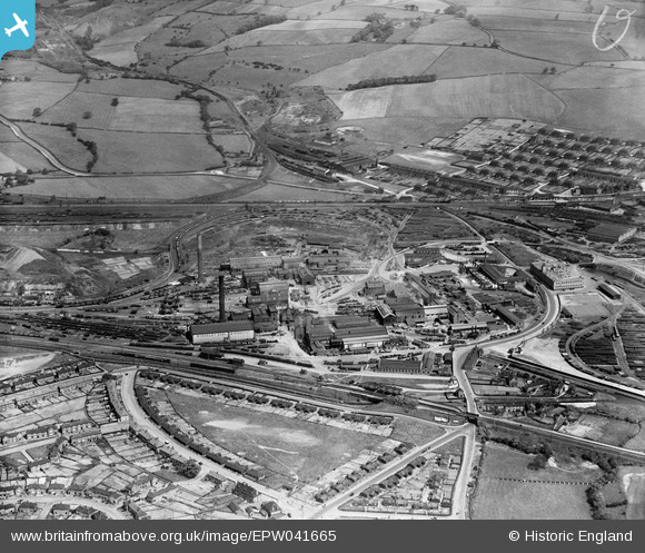
EPW041665 ENGLAND (1933). The Staveley Iron Works, Staveley, 1933
© Hawlfraint cyfranwyr OpenStreetMap a thrwyddedwyd gan yr OpenStreetMap Foundation. 2026. Trwyddedir y gartograffeg fel CC BY-SA.
Delweddau cyfagos (15)
Manylion
| Pennawd | [EPW041665] The Staveley Iron Works, Staveley, 1933 |
| Cyfeirnod | EPW041665 |
| Dyddiad | June-1933 |
| Dolen | |
| Enw lle | STAVELEY |
| Plwyf | STAVELEY |
| Ardal | |
| Gwlad | ENGLAND |
| Dwyreiniad / Gogleddiad | 441377, 374987 |
| Hydred / Lledred | -1.3795081864022, 53.269979896029 |
| Cyfeirnod Grid Cenedlaethol | SK414750 |
Pinnau

topbrewer |
Monday 23rd of January 2017 04:26:59 PM | |

topbrewer |
Monday 23rd of January 2017 04:26:42 PM | |

topbrewer |
Monday 23rd of January 2017 04:25:00 PM | |

topbrewer |
Monday 23rd of January 2017 04:24:35 PM | |

topbrewer |
Monday 23rd of January 2017 04:23:50 PM | |

Don Rawding |
Friday 25th of December 2015 05:35:45 AM | |

mattspriggs28 |
Monday 7th of April 2014 01:37:35 PM |


![[EPW041665] The Staveley Iron Works, Staveley, 1933](http://britainfromabove.org.uk/sites/all/libraries/aerofilms-images/public/100x100/EPW/041/EPW041665.jpg)
![[EAW044348] The Staveley Coal and Iron Company Ltd Works, Staveley, 1952](http://britainfromabove.org.uk/sites/all/libraries/aerofilms-images/public/100x100/EAW/044/EAW044348.jpg)
![[EPW041666] The Staveley Iron Works, Staveley, 1933](http://britainfromabove.org.uk/sites/all/libraries/aerofilms-images/public/100x100/EPW/041/EPW041666.jpg)
![[EPW041668] The Staveley Iron Works and environs, Staveley, 1933](http://britainfromabove.org.uk/sites/all/libraries/aerofilms-images/public/100x100/EPW/041/EPW041668.jpg)
![[EPW057352] The Staveley Coal and Iron Company Ltd Works, Staveley, 1938](http://britainfromabove.org.uk/sites/all/libraries/aerofilms-images/public/100x100/EPW/057/EPW057352.jpg)
![[EPW041669] The Staveley Iron Works, Staveley, 1933](http://britainfromabove.org.uk/sites/all/libraries/aerofilms-images/public/100x100/EPW/041/EPW041669.jpg)
![[EPW041671] The Staveley Iron Works and environs, Staveley, 1933](http://britainfromabove.org.uk/sites/all/libraries/aerofilms-images/public/100x100/EPW/041/EPW041671.jpg)
![[EAW003072] The Staveley Iron Works, Staveley, 1946](http://britainfromabove.org.uk/sites/all/libraries/aerofilms-images/public/100x100/EAW/003/EAW003072.jpg)
![[EAW003057] The Staveley Iron Works, Staveley Works Station and environs, Staveley, 1946](http://britainfromabove.org.uk/sites/all/libraries/aerofilms-images/public/100x100/EAW/003/EAW003057.jpg)
![[EPW041670] The Staveley Iron Works and environs, Staveley, 1933](http://britainfromabove.org.uk/sites/all/libraries/aerofilms-images/public/100x100/EPW/041/EPW041670.jpg)
![[EPW057341] The Staveley Coal and Iron Company Ltd Works, Staveley, 1938](http://britainfromabove.org.uk/sites/all/libraries/aerofilms-images/public/100x100/EPW/057/EPW057341.jpg)
![[EPW041667] The Staveley Iron Works, Staveley, 1933](http://britainfromabove.org.uk/sites/all/libraries/aerofilms-images/public/100x100/EPW/041/EPW041667.jpg)
![[EPW041672] The Staveley Iron Works, Staveley, 1933. This image has been affected by flare.](http://britainfromabove.org.uk/sites/all/libraries/aerofilms-images/public/100x100/EPW/041/EPW041672.jpg)
![[EPW057342] The Staveley Coal and Iron Company Ltd Works, Staveley, 1938](http://britainfromabove.org.uk/sites/all/libraries/aerofilms-images/public/100x100/EPW/057/EPW057342.jpg)
![[EAW003058] The Staveley Iron Works and environs, Staveley, from the south-east, 1946](http://britainfromabove.org.uk/sites/all/libraries/aerofilms-images/public/100x100/EAW/003/EAW003058.jpg)