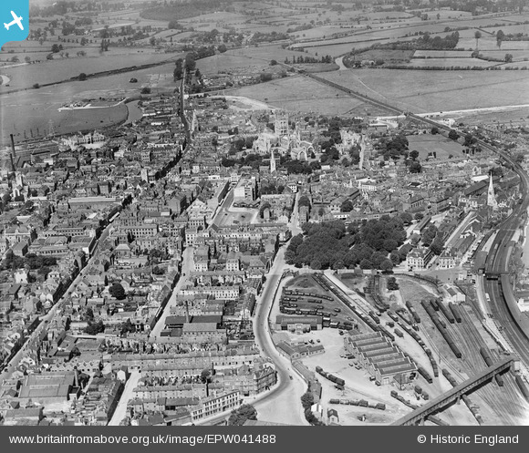
EPW041488 ENGLAND (1933). Station Road, Russell Street and the city centre, Gloucester, 1933
    © Hawlfraint cyfranwyr OpenStreetMap a thrwyddedwyd gan yr OpenStreetMap Foundation. 2025. Trwyddedir y gartograffeg fel CC BY-SA.
  
Delweddau cyfagos (10)
Manylion
| Pennawd | [EPW041488] Station Road, Russell Street and the city centre, Gloucester, 1933 | 
| Cyfeirnod | EPW041488 | 
| Dyddiad | July-1933 | 
| Dolen | |
| Enw lle | GLOUCESTER | 
| Plwyf | |
| Ardal | |
| Gwlad | ENGLAND | 
| Dwyreiniad / Gogleddiad | 383377, 218567 | 
| Hydred / Lledred | -2.2414371834823, 51.8649939445 | 
| Cyfeirnod Grid Cenedlaethol | SO834186 | 
Pinnau
|  Eastcourt Road (under construction ?) |   gBr | Wednesday 14th of December 2016 03:01:56 PM | 
|  35 Prince St. |   robinl | Sunday 10th of January 2016 02:45:52 PM | 
|  railway water pumping house to supply the stations |   ozzy | Saturday 20th of September 2014 02:35:35 PM | 
|  All that is left of the Midland Railway is this short section of wall in Station Road |   ozzy | Saturday 20th of September 2014 02:32:46 PM | 
|  The Spread Eagle Hotel |   ozzy | Saturday 20th of September 2014 12:13:53 PM | 
|  Gloucester West Signal Box |   ozzy | Saturday 20th of September 2014 11:58:30 AM | 
|  The Royal Hotel |   ozzy | Saturday 20th of September 2014 11:41:13 AM | 
|  Horse and Groom Pub now demolished |   ozzy | Saturday 20th of September 2014 11:39:13 AM | 
|  Docks Branch Line |   ozzy | Tuesday 9th of September 2014 09:46:49 AM | 
|  Hereford Bay |   ozzy | Tuesday 9th of September 2014 09:44:45 AM | 
|  The Deans Walk Pub |   ozzy | Tuesday 9th of September 2014 09:26:33 AM | 
|  The Ledbury and Gloucester Railway ( also known as the Daffodil Line ) opened in 1885 and closed in 1964. |   ozzy | Tuesday 9th of September 2014 09:15:14 AM | 
|  midland railway p/way offices and stables |   ozzy | Tuesday 9th of September 2014 08:58:13 AM | 
|  Gloucester Cross |   calladhor | Tuesday 28th of May 2013 07:46:29 PM | 
|  The Glevum Hotel in Whitfield Street was a Temperance Hotel, in 1914. |   JonB | Thursday 9th of May 2013 06:44:45 PM | 
|  Over Bridge |   Richcl | Sunday 5th of May 2013 02:49:32 PM | 
|  St Catherine's Viaduct |   Richcl | Sunday 5th of May 2013 02:47:20 PM | 
|  Gloucester Cathedral |   Richcl | Sunday 5th of May 2013 02:46:38 PM | 
|  Westgate Street |   Richcl | Sunday 5th of May 2013 02:46:18 PM | 
|  Eastgate Street |   Richcl | Sunday 5th of May 2013 02:46:01 PM | 
|  St Peter's Church |   Richcl | Sunday 5th of May 2013 02:44:29 PM | 
|  Station Road |   Richcl | Sunday 5th of May 2013 02:43:58 PM | 
|  King's Square |   Richcl | Sunday 5th of May 2013 02:43:06 PM | 
|  Became Gloucester Bus Station |   Richcl | Sunday 5th of May 2013 02:41:46 PM | 
| But still the Cattle Market at the time of photo. |   gBr | Monday 28th of July 2014 01:51:28 PM | 
Cyfraniadau Grŵp
| Eastgate market original location. Façade moved 100 yards east in late 60's when the Bell hotel and Bell lane sites were redeveloped. |   calladhor | Tuesday 28th of May 2013 08:05:00 PM | 
 
             
  ![[EPW041488] Station Road, Russell Street and the city centre, Gloucester, 1933](http://britainfromabove.org.uk/sites/all/libraries/aerofilms-images/public/100x100/EPW/041/EPW041488.jpg) 
  
                                          ![[EPW037845] King's Square and environs, Gloucester, 1932](http://britainfromabove.org.uk/sites/all/libraries/aerofilms-images/public/100x100/EPW/037/EPW037845.jpg) 
 ![[EPW037846] The cattle market, King's Square and the city centre, Gloucester, 1932](http://britainfromabove.org.uk/sites/all/libraries/aerofilms-images/public/100x100/EPW/037/EPW037846.jpg) 
 ![[EPW037844] The cattle market, St Aldate Street and the city centre, Gloucester, 1932](http://britainfromabove.org.uk/sites/all/libraries/aerofilms-images/public/100x100/EPW/037/EPW037844.jpg) 
 ![[EPW006016] The city centre, Gloucester, 1921. This image has been produced from a copy-negative.](http://britainfromabove.org.uk/sites/all/libraries/aerofilms-images/public/100x100/EPW/006/EPW006016.jpg) 
 ![[EPW001179] Gloucester Cathedral, Station and town centre, Gloucester, 1920](http://britainfromabove.org.uk/sites/all/libraries/aerofilms-images/public/100x100/EPW/001/EPW001179.jpg) 
 ![[EAW000727] Holy Trinity Cathedral and the city, Gloucester, 1946](http://britainfromabove.org.uk/sites/all/libraries/aerofilms-images/public/100x100/EAW/000/EAW000727.jpg) 
 ![[EAW032306] Holy Trinity Cathedral, Gloucester, 1950](http://britainfromabove.org.uk/sites/all/libraries/aerofilms-images/public/100x100/EAW/032/EAW032306.jpg) 
 ![[EAW003568] Gloucester Cathedral, Gloucester, 1947](http://britainfromabove.org.uk/sites/all/libraries/aerofilms-images/public/100x100/EAW/003/EAW003568.jpg) 
 ![[EAW003569] Gloucester Cathedral, Gloucester, 1947](http://britainfromabove.org.uk/sites/all/libraries/aerofilms-images/public/100x100/EAW/003/EAW003569.jpg)