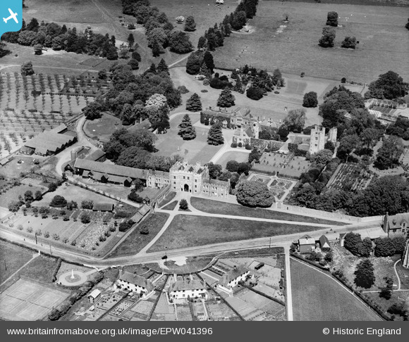
EPW041396 ENGLAND (1933). St Osyth's Priory, St Osyth, 1933
© Hawlfraint cyfranwyr OpenStreetMap a thrwyddedwyd gan yr OpenStreetMap Foundation. 2026. Trwyddedir y gartograffeg fel CC BY-SA.
Delweddau cyfagos (17)
Manylion
| Pennawd | [EPW041396] St Osyth's Priory, St Osyth, 1933 |
| Cyfeirnod | EPW041396 |
| Dyddiad | May-1933 |
| Dolen | |
| Enw lle | ST OSYTH |
| Plwyf | ST. OSYTH |
| Ardal | |
| Gwlad | ENGLAND |
| Dwyreiniad / Gogleddiad | 612112, 215672 |
| Hydred / Lledred | 1.076616730221, 51.798950699531 |
| Cyfeirnod Grid Cenedlaethol | TM121157 |
Pinnau

totoro |
Tuesday 3rd of June 2014 11:01:38 PM | |

totoro |
Tuesday 3rd of June 2014 10:58:52 PM | |

totoro |
Tuesday 3rd of June 2014 10:57:24 PM | |

totoro |
Tuesday 3rd of June 2014 10:56:26 PM | |

totoro |
Tuesday 3rd of June 2014 10:55:26 PM | |

totoro |
Tuesday 3rd of June 2014 10:54:41 PM | |

totoro |
Tuesday 3rd of June 2014 10:53:36 PM | |

totoro |
Tuesday 3rd of June 2014 10:52:45 PM | |

totoro |
Tuesday 3rd of June 2014 10:51:37 PM | |

totoro |
Tuesday 3rd of June 2014 10:50:28 PM | |

totoro |
Tuesday 3rd of June 2014 10:49:17 PM | |

totoro |
Tuesday 3rd of June 2014 10:47:49 PM | |

totoro |
Tuesday 3rd of June 2014 10:45:08 PM | |

totoro |
Tuesday 3rd of June 2014 10:44:05 PM | |

totoro |
Tuesday 3rd of June 2014 10:42:30 PM | |

totoro |
Tuesday 3rd of June 2014 10:41:01 PM | |

totoro |
Tuesday 3rd of June 2014 10:38:30 PM |
Cyfraniadau Grŵp

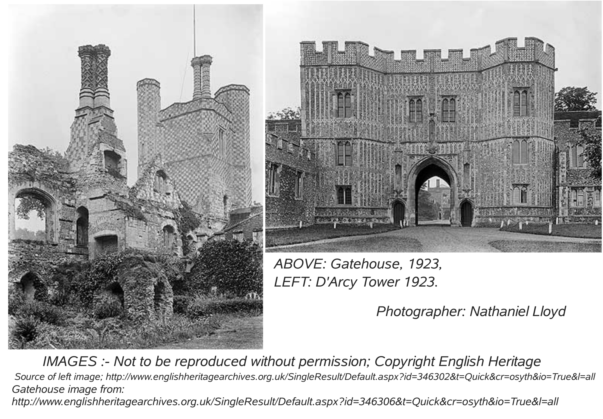
IMAGES of GATEHOUSE and D'ARCY TOWER in 1923, Photographer: Nathaniel Lloyd Not to be reproduced without permission; Copyright English Heritage Image Sources: both url's commence: http://www.englishheritagearchives.org.uk/SingleResult/Default.aspx? then after the ? continue: for gatehouse: id=287520&t=Quick&cr=osyth&io=True&l=all for tower: id=346302&t=Quick&cr=osyth&io=True&l=all |

totoro |
Wednesday 4th of June 2014 05:57:16 PM |
St Osyth's Priory, Brightlingsea, Essex, CO16 8NZ There are many separately listed buildings and structures in this image- a list of some listed structures in this location can be found at the end of this note. The house at St Osyth was originally a medieval priory and the present house incorporates fabric from the 12th century onwards. The monastery began as a priory. Founded by Richard de Belmeis, Bishop of London, c.1121 for the Austin Canons. The first prior of St Osyth's was William de Corbeil, who was elected archbishop of Canterbury in 1123 and who crowned King Stephen in 1135. The priory became an Augustinian Abbey in about 1200 AD. The Frater was rebuilt c1230-1240, with the vaulted passage to the east of it. The vaults in the west range were built around the end of the 13th century. The great gatehouse and the ranges flanking and projecting south from it date from the late 15th century. 1306. The abbot carried off a cross belonging to the hospital of Dunwich in Suffolk, and took it to the abbey. The brethren of the hospital complained to the king that they had suffered serious loss through this by the diminution of the alms given by visitors, and the case was tried in Chancery, with the result that the abbot was defeated and the cross restored to the hospital. Dissolved by King Henry VIII in 1539. It came into the possession of Lord Darcy in 1553, he converted it into a house, destroying some parts and making additions. The church was destroyed and the site became the rose garden. About 1600 a large red brick built house was erected on the site of the northern portion of the cloister. In the seventeenth or eighteenth century the eastern portion of the buildings fell into ruin, and in the mid-eighteenth century the wing to the west of the Bishops Lodging was built. The final building phase was in 1866 with the rebuilding of the Bishops Lodging (apart from the south front, dating from c1527.) and the addition of a wing on the east of it. St Osyth's Priory has a mid-18th-century landscape park and grounds of 76 hectares. The central parts of the grounds, consisting of 7 hectares of gardens, were largely developed in the 19th century. With the site having so many ancient listed buildings, ancient monuments and listed gardens, in private ownership, there is a major problem to maintain them (or even prevent them collapsing) and several of the buildings at St Osyth's have decayed quite badly. National funding is not available and although listing a building adds legal requirements which vastly increase the cost of even minor repairs, there is no duty to repair. In 2010 proposals were put forward for a development of over 300 new dwellings within the estate grounds but without interfering with views of the priory, the funds raised going towards the renovation of the priory. A number of local residents were unhappy with the proposals. The buildings were on the 2013 English Heritage "at risk" register. Strongly recommended reading: 2011- English Heritage: "74/2011 - St Osyth's Priory, St Osyth, Essex: Historic Buildings Report", "Research Department Report" by P Smith. See http://research.english-heritage.org.uk/report/?15026 The plan in the report has been referred to to identify the locations of various parts of the site. List of the "Listed Buildings" listed under "St Osyth's Priory": St Osyth's Priory Brewhouse North West of Gatehouse, St Osyth's Priory Cartlodge Adjacent to West of Barn, . St Osyth's Priory Convalescent Home, . St Osyth's Priory Cottage Adjoining Outbuilding Qv 15/189, . St Osyth's Priory Garden Wall Attached to Darcy Tower to North and Precinct Wall to South, . St Osyth's Priory Garden Wall Attached to Darcy Wall to South and East Range of Gatehouse to North w, . St Osyth's Priory Ornamental Steps Flanked by Urns in Courtyard Approximately 100 Metres North of Ga, . St Osyth's Priory Outbuilding Adjacent Northwest of Brewhouse Now a Dairy Q.v. 15/193, . St Osyth's Priory Outbuilding Adjacent to North of Dairy Qv 15/188 Now a Barn, . St Osyth's Priory Precinct Wall Countinuing South of Wall, . St Osyth's Priory Precinct Wall Running East of Gatehouse Turning North East and Flanking Colchester, . St Osyth's Priory Precinct Wall to South West of Gatehouse, . St Osyth's Priory Pump Approximately 20 Metres West of Cottage Listed Qv 14/190, . St Osyth's Priory Ruined East Range and Tower, . St Osyth's Priory Stable Block Adjacent to North West of Barn, . St Osyth's Priory Urn and Pedestal in Courtyard Approximately 50 Metres North of Gatehouse, . St Osyth's Priory Urn and Stone Pedestal Approximately 50 Metres North East of the Abbots Lodging, . St Osyth's Priory Wall Between Southern Wing of Convalescent Home Qv 15/197 and Darcy Tower Qv 15/19, . St Osyth's Priory the Chapel of St Osyth and Ruins Attached to North, . St Osyth's Priory the Darcy Tower Also Known As Abbot's Tower and Vaulting to West, . St Osyth's Priory, Barn Adjoining the West Range of Gatehouse, . St Osyth's Priory, Gatehouse and East and West Flanking Ranges, . |

totoro |
Tuesday 3rd of June 2014 08:40:14 PM |


![[EPW041396] St Osyth's Priory, St Osyth, 1933](http://britainfromabove.org.uk/sites/all/libraries/aerofilms-images/public/100x100/EPW/041/EPW041396.jpg)
![[EAW048918] St Osyth's Priory, St Osyth, 1953](http://britainfromabove.org.uk/sites/all/libraries/aerofilms-images/public/100x100/EAW/048/EAW048918.jpg)
![[EPW041397] St Osyth's Priory, St Osyth, 1933](http://britainfromabove.org.uk/sites/all/libraries/aerofilms-images/public/100x100/EPW/041/EPW041397.jpg)
![[EAW038339] St Osyth's Priory, St Osyth, 1951. This image has been produced from a print.](http://britainfromabove.org.uk/sites/all/libraries/aerofilms-images/public/100x100/EAW/038/EAW038339.jpg)
![[EAW048913] St Osyth's Priory, St Osyth, 1953](http://britainfromabove.org.uk/sites/all/libraries/aerofilms-images/public/100x100/EAW/048/EAW048913.jpg)
![[EAW038340] St Osyth's Priory, St Osyth, 1951. This image has been produced from a print.](http://britainfromabove.org.uk/sites/all/libraries/aerofilms-images/public/100x100/EAW/038/EAW038340.jpg)
![[EAW048917] St Osyth's Priory, St Osyth, from the north-east, 1953](http://britainfromabove.org.uk/sites/all/libraries/aerofilms-images/public/100x100/EAW/048/EAW048917.jpg)
![[EAW024667] St Osyth's Priory, St Osyth, from the south-west, 1949](http://britainfromabove.org.uk/sites/all/libraries/aerofilms-images/public/100x100/EAW/024/EAW024667.jpg)
![[EPW011629] St Osyth's Priory, St Osyth, 1924. This image has been produced from a print.](http://britainfromabove.org.uk/sites/all/libraries/aerofilms-images/public/100x100/EPW/011/EPW011629.jpg)
![[EAW024666] St Osyth's Priory, St Osyth, from the north-east, 1949](http://britainfromabove.org.uk/sites/all/libraries/aerofilms-images/public/100x100/EAW/024/EAW024666.jpg)
![[EAW024665] St Osyth's Priory, St Osyth, from the south-east, 1949](http://britainfromabove.org.uk/sites/all/libraries/aerofilms-images/public/100x100/EAW/024/EAW024665.jpg)
![[EAW024668] St Osyth's Priory, St Osyth, from the south-east, 1949](http://britainfromabove.org.uk/sites/all/libraries/aerofilms-images/public/100x100/EAW/024/EAW024668.jpg)
![[EAW048915] St Osyth's Priory, St Osyth, 1953](http://britainfromabove.org.uk/sites/all/libraries/aerofilms-images/public/100x100/EAW/048/EAW048915.jpg)
![[EAW048920] St Osyth's Priory, St Osyth, 1953](http://britainfromabove.org.uk/sites/all/libraries/aerofilms-images/public/100x100/EAW/048/EAW048920.jpg)
![[EAW048916] St Osyth's Priory, St Osyth, 1953](http://britainfromabove.org.uk/sites/all/libraries/aerofilms-images/public/100x100/EAW/048/EAW048916.jpg)
![[EPW049032] St Osyth Park and the village, St Osyth, 1935. This image has been produced from a copy-negative.](http://britainfromabove.org.uk/sites/all/libraries/aerofilms-images/public/100x100/EPW/049/EPW049032.jpg)
![[EAW048914] St Osyth's Priory and St Osyth Park, St Osyth, from the south-east, 1953](http://britainfromabove.org.uk/sites/all/libraries/aerofilms-images/public/100x100/EAW/048/EAW048914.jpg)