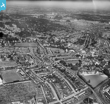
EPW040465 ENGLAND (1932). Kings Ward and environs, West Watford, from the south-east, 1932
© Hawlfraint cyfranwyr OpenStreetMap a thrwyddedwyd gan yr OpenStreetMap Foundation. 2026. Trwyddedir y gartograffeg fel CC BY-SA.
Delweddau cyfagos (14)
Manylion
| Pennawd | [EPW040465] Kings Ward and environs, West Watford, from the south-east, 1932 |
| Cyfeirnod | EPW040465 |
| Dyddiad | September-1932 |
| Dolen | |
| Enw lle | WEST WATFORD |
| Plwyf | |
| Ardal | |
| Gwlad | ENGLAND |
| Dwyreiniad / Gogleddiad | 510902, 195800 |
| Hydred / Lledred | -0.39682722131516, 51.649575581214 |
| Cyfeirnod Grid Cenedlaethol | TQ109958 |
Pinnau

John Swain |
Wednesday 4th of September 2013 07:57:03 PM | |

John Swain |
Wednesday 4th of September 2013 07:54:49 PM | |

John Swain |
Wednesday 4th of September 2013 07:52:59 PM | |

John Swain |
Wednesday 4th of September 2013 07:52:23 PM | |

John Swain |
Wednesday 4th of September 2013 07:50:15 PM | |

John Swain |
Wednesday 4th of September 2013 07:49:13 PM | |

John Swain |
Wednesday 4th of September 2013 07:48:01 PM | |

John Swain |
Wednesday 4th of September 2013 07:47:16 PM | |

John Swain |
Wednesday 4th of September 2013 07:46:38 PM | |

John Swain |
Wednesday 4th of September 2013 07:45:22 PM | |

John Swain |
Wednesday 4th of September 2013 07:44:22 PM | |

John Swain |
Wednesday 4th of September 2013 07:43:25 PM | |

John Swain |
Wednesday 4th of September 2013 07:42:38 PM | |

John Swain |
Wednesday 4th of September 2013 07:41:52 PM | |

John Swain |
Wednesday 4th of September 2013 07:38:45 PM | |

John Swain |
Wednesday 4th of September 2013 07:36:03 PM | |

John Swain |
Wednesday 4th of September 2013 07:35:16 PM | |

John Swain |
Wednesday 4th of September 2013 07:34:34 PM | |

John Swain |
Wednesday 4th of September 2013 07:33:57 PM | |

John Swain |
Wednesday 4th of September 2013 07:32:45 PM | |

John Swain |
Wednesday 4th of September 2013 07:31:56 PM |
Cyfraniadau Grŵp
An interesting snapshot of Watford in the early Thirties, when the town continued to grow to around 56,000 inhabitants, from a figure of 45,000 in 1921. Looking north-west in this viewpoint, it's easy to appreciate how RAF pilots flying over Watford less than ten years hence would consider the urban area to be made up of parkland as much as industrial or commercial uses. |

John Swain |
Wednesday 4th of September 2013 08:03:44 PM |


![[EPW040465] Kings Ward and environs, West Watford, from the south-east, 1932](http://britainfromabove.org.uk/sites/all/libraries/aerofilms-images/public/100x100/EPW/040/EPW040465.jpg)
![[EAW027890] Watford, the FA Cup 4th Round football match between Watford and Manchester United (0 - 1) underway at Vicarage Road Stadium (site of), from the north-east, 1950. This image has been produced from a damaged negative.](http://britainfromabove.org.uk/sites/all/libraries/aerofilms-images/public/100x100/EAW/027/EAW027890.jpg)
![[EAW027889] Watford, the FA Cup 4th Round football match between Watford and Manchester United (0 - 1) underway at Vicarage Road Stadium, from the east, 1950. This image has been produced from a print.](http://britainfromabove.org.uk/sites/all/libraries/aerofilms-images/public/100x100/EAW/027/EAW027889.jpg)
![[EAW027893] Watford, the FA Cup 4th Round football match between Watford and Manchester United (0 - 1) underway at Vicarage Road Stadium, from the south-east, 1950. This image has been produced from a print marked by Aerofilms Ltd for photo editing.](http://britainfromabove.org.uk/sites/all/libraries/aerofilms-images/public/100x100/EAW/027/EAW027893.jpg)
![[EAW027887] Watford, the FA Cup 4th Round football match between Watford and Manchester United (0 - 1) about to begin at Vicarage Road Stadium, 1950. This image has been produced from a print marked by Aerofilms Ltd for photo editing.](http://britainfromabove.org.uk/sites/all/libraries/aerofilms-images/public/100x100/EAW/027/EAW027887.jpg)
![[EAW027888] Watford, the FA Cup 4th Round football match between Watford and Manchester United (0 - 1) about to begin at Vicarage Road Stadium, 1950. This image has been produced from a print.](http://britainfromabove.org.uk/sites/all/libraries/aerofilms-images/public/100x100/EAW/027/EAW027888.jpg)
![[EPW039621] Vicarage Road Football Ground, Watford, 1932](http://britainfromabove.org.uk/sites/all/libraries/aerofilms-images/public/100x100/EPW/039/EPW039621.jpg)
![[EAW027886] Watford, the FA Cup 4th Round football match between Watford and Manchester United (0 - 1) about to begin at Vicarage Road Stadium, 1950. This image has been produced from a print marked by Aerofilms Ltd for photo editing.](http://britainfromabove.org.uk/sites/all/libraries/aerofilms-images/public/100x100/EAW/027/EAW027886.jpg)
![[EAW027891] Watford, the FA Cup 4th Round football match between Watford and Manchester United (0 - 1) underway at Vicarage Road Stadium, 1950. This image has been produced from a damaged negative.](http://britainfromabove.org.uk/sites/all/libraries/aerofilms-images/public/100x100/EAW/027/EAW027891.jpg)
![[EPW039622] Vicarage Road Football Ground and environs, Watford, 1932](http://britainfromabove.org.uk/sites/all/libraries/aerofilms-images/public/100x100/EPW/039/EPW039622.jpg)
![[EAW027894] Watford, the FA Cup 4th Round football match between Watford and Manchester United (0 - 1) underway at Vicarage Road Stadium, from the south-east, 1950. This image has been produced from a print marked by Aerofilms Ltd for photo editing.](http://britainfromabove.org.uk/sites/all/libraries/aerofilms-images/public/100x100/EAW/027/EAW027894.jpg)
![[EAW026501] Watford, Football match between Watford and Port Vale at Vicarage Road, 1949](http://britainfromabove.org.uk/sites/all/libraries/aerofilms-images/public/100x100/EAW/026/EAW026501.jpg)
![[EAW027892] Watford, the FA Cup 4th Round football match between Watford and Manchester United (0 - 1) underway at Vicarage Road Stadium, 1950. This image has been produced from a damaged negative.](http://britainfromabove.org.uk/sites/all/libraries/aerofilms-images/public/100x100/EAW/027/EAW027892.jpg)
![[EPW010539] The Watford and Rickmansworth Branch Railway, allotments, Vicarage Road Football Ground and environs, Watford, 1924. This image has been produced from a copy-negative.](http://britainfromabove.org.uk/sites/all/libraries/aerofilms-images/public/100x100/EPW/010/EPW010539.jpg)
