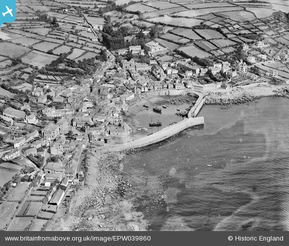
EPW039860 ENGLAND (1932). The harbour and the village, Mousehole, 1932
    © Hawlfraint cyfranwyr OpenStreetMap a thrwyddedwyd gan yr OpenStreetMap Foundation. 2025. Trwyddedir y gartograffeg fel CC BY-SA.
  
Delweddau cyfagos (6)
Manylion
| Pennawd | [EPW039860] The harbour and the village, Mousehole, 1932 | 
| Cyfeirnod | EPW039860 | 
| Dyddiad | August-1932 | 
| Dolen | |
| Enw lle | MOUSEHOLE | 
| Plwyf | PENZANCE | 
| Ardal | |
| Gwlad | ENGLAND | 
| Dwyreiniad / Gogleddiad | 146956, 26304 | 
| Hydred / Lledred | -5.5375977497218, 50.082245292863 | 
| Cyfeirnod Grid Cenedlaethol | SW470263 | 
Pinnau
Byddwch y cyntaf i ychwanegu sylw at y ddelwedd hon!
 
             
  ![[EPW039860] The harbour and the village, Mousehole, 1932](http://britainfromabove.org.uk/sites/all/libraries/aerofilms-images/public/100x100/EPW/039/EPW039860.jpg) 
  
                                          ![[EAW033637] The harbour and village, Mousehole, 1950](http://britainfromabove.org.uk/sites/all/libraries/aerofilms-images/public/100x100/EAW/033/EAW033637.jpg) 
 ![[EAW033638] The harbour and village, Mousehole, 1950](http://britainfromabove.org.uk/sites/all/libraries/aerofilms-images/public/100x100/EAW/033/EAW033638.jpg) 
 ![[EAW033639] The harbour and village, Mousehole, 1950](http://britainfromabove.org.uk/sites/all/libraries/aerofilms-images/public/100x100/EAW/033/EAW033639.jpg) 
 ![[EPW039858] The harbour and the village, Mousehole, 1932](http://britainfromabove.org.uk/sites/all/libraries/aerofilms-images/public/100x100/EPW/039/EPW039858.jpg) 
 ![[EPW059871] The harbour and village, Mousehole, 1938](http://britainfromabove.org.uk/sites/all/libraries/aerofilms-images/public/100x100/EPW/059/EPW059871.jpg)