
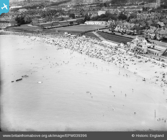
EPW039396 ENGLAND. Westbrook Bay, Margate, 1932
© Hawlfraint cyfranwyr OpenStreetMap a thrwyddedwyd gan yr OpenStreetMap Foundation. 2026. Trwyddedir y gartograffeg fel CC BY-SA.
Delweddau cyfagos (3)
EPW039396

EPW018608

EPW000629

Manylion
| Pennawd | [EPW039396] Westbrook Bay, Margate, 1932 |
| Cyfeirnod | EPW039396 |
| Dyddiad | |
| Dolen | |
| Enw lle | MARGATE |
| Plwyf | |
| Ardal | |
| Gwlad | ENGLAND |
| Dwyreiniad / Gogleddiad | 634119, 170592 |
| Hydred / Lledred | 1.365179558114, 51.385502842803 |
| Cyfeirnod Grid Cenedlaethol | TR341706 |
Pinnau

Mark Godden |
Sunday 20th of April 2025 10:41:51 AM | |
|
Mark Godden |
Sunday 20th of April 2025 10:41:25 AM | |
|
Ian |
Friday 14th of December 2012 08:31:18 AM | |
|
Ian |
Friday 14th of December 2012 08:30:27 AM | |
|
Ian |
Thursday 13th of December 2012 12:49:56 PM | |
|
David Hendry |
Wednesday 12th of December 2012 10:58:00 PM |
Cyfraniadau Grŵp
Westbrook Bay, Margate. Centre of view at 634140,170590, since there is no location editor. View southeast. |

Dylan Moore |
Thursday 3rd of January 2013 10:20:25 AM |
Hi DYlan, Thanks for spotting this one. We'll update the catalogue and post the correct location data to the record here in due course. Yours, Katy Britain from Above Cataloguing Team Leader |
Katy Whitaker |
Thursday 3rd of January 2013 10:20:25 AM |