
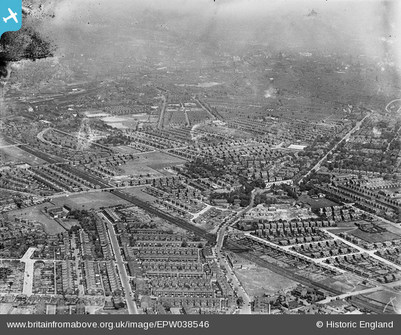
EPW038546 ENGLAND (1932). Manchester Road, Upper Chorlton Road and housing at Old Trafford, Chorlton-cum-Hardy, from the south-west, 1932. This image has been produced from a damaged negative.
© Hawlfraint cyfranwyr OpenStreetMap a thrwyddedwyd gan yr OpenStreetMap Foundation. 2026. Trwyddedir y gartograffeg fel CC BY-SA.
Delweddau cyfagos (2)
EPW038546

EPW038545

Manylion
| Pennawd | [EPW038546] Manchester Road, Upper Chorlton Road and housing at Old Trafford, Chorlton-cum-Hardy, from the south-west, 1932. This image has been produced from a damaged negative. |
| Cyfeirnod | EPW038546 |
| Dyddiad | June-1932 |
| Dolen | |
| Enw lle | CHORLTON-CUM-HARDY |
| Plwyf | |
| Ardal | |
| Gwlad | ENGLAND |
| Dwyreiniad / Gogleddiad | 381733, 394722 |
| Hydred / Lledred | -2.2750801624271, 53.448688710689 |
| Cyfeirnod Grid Cenedlaethol | SJ817947 |
Pinnau

Duncan Edwards |
Sunday 22nd of June 2025 11:57:10 AM | |
|
Gem |
Monday 19th of September 2022 10:13:44 PM | |
|
effigy |
Tuesday 13th of October 2020 04:00:03 PM | |
|
effigy |
Tuesday 13th of October 2020 03:59:01 PM | |
|
Bob |
Sunday 11th of June 2017 07:42:22 PM | |
|
John Ellis |
Wednesday 27th of March 2013 12:09:23 PM | |
|
John Ellis |
Wednesday 27th of March 2013 12:05:30 PM | |
|
John Ellis |
Wednesday 27th of March 2013 12:03:13 PM | |
|
John Ellis |
Wednesday 27th of March 2013 12:01:55 PM | |
|
John Ellis |
Wednesday 27th of March 2013 11:36:34 AM | |
|
John Ellis |
Wednesday 27th of March 2013 11:35:53 AM | |
|
John Ellis |
Wednesday 27th of March 2013 11:35:18 AM | |
|
John Ellis |
Wednesday 27th of March 2013 11:32:48 AM | |
|
John Ellis |
Wednesday 27th of March 2013 11:32:16 AM | |
|
John Ellis |
Wednesday 27th of March 2013 11:31:42 AM | |
|
John Ellis |
Wednesday 27th of March 2013 11:30:56 AM | |
|
John Ellis |
Wednesday 27th of March 2013 11:29:48 AM | |
|
John Ellis |
Wednesday 27th of March 2013 11:28:53 AM | |
|
John Ellis |
Wednesday 27th of March 2013 11:28:25 AM | |
|
John Ellis |
Wednesday 27th of March 2013 11:27:39 AM | |
|
John Ellis |
Wednesday 27th of March 2013 11:27:01 AM | |
|
John Ellis |
Wednesday 27th of March 2013 11:26:22 AM | |
|
John Ellis |
Wednesday 27th of March 2013 11:25:55 AM | |
|
John Ellis |
Wednesday 27th of March 2013 11:25:30 AM | |
|
John Ellis |
Wednesday 27th of March 2013 11:24:59 AM | |
|
John Ellis |
Wednesday 27th of March 2013 11:23:42 AM | |
|
John Ellis |
Wednesday 27th of March 2013 10:45:48 AM | |
|
John Ellis |
Wednesday 27th of March 2013 10:43:58 AM | |
|
John Ellis |
Wednesday 27th of March 2013 10:43:28 AM | |
|
John Ellis |
Wednesday 27th of March 2013 10:41:06 AM | |
|
John Ellis |
Tuesday 26th of March 2013 10:20:06 PM | |
|
John Ellis |
Tuesday 26th of March 2013 10:18:51 PM | |
|
John Ellis |
Tuesday 26th of March 2013 10:16:15 PM | |
 |
MWM |
Thursday 13th of December 2012 11:22:08 AM |
|
MWM |
Thursday 13th of December 2012 11:18:39 AM | |
|
MWM |
Thursday 13th of December 2012 11:16:07 AM | |
Correction - it is Fir Farm |
MWM |
Sunday 16th of December 2012 01:05:37 PM |
|
MWM |
Thursday 13th of December 2012 11:15:39 AM |