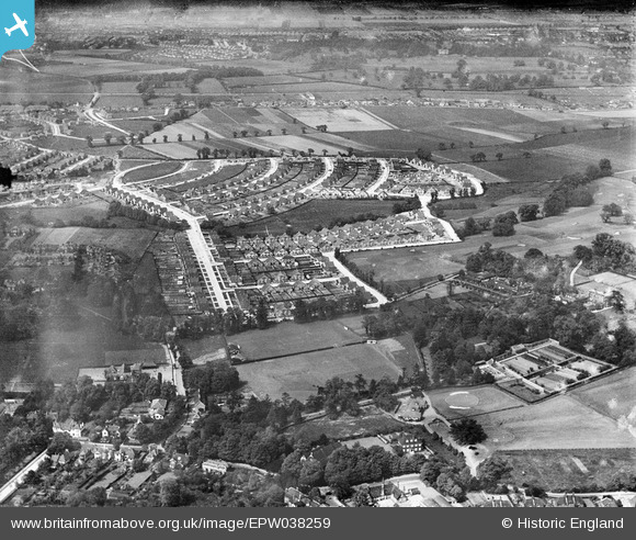
EPW038259 ENGLAND (1932). New housing around Marlborough Park and environs, Sidcup, 1932
    © Hawlfraint cyfranwyr OpenStreetMap a thrwyddedwyd gan yr OpenStreetMap Foundation. 2025. Trwyddedir y gartograffeg fel CC BY-SA.
  
Delweddau cyfagos (6)
Manylion
| Pennawd | [EPW038259] New housing around Marlborough Park and environs, Sidcup, 1932 | 
| Cyfeirnod | EPW038259 | 
| Dyddiad | July-1932 | 
| Dolen | |
| Enw lle | SIDCUP | 
| Plwyf | |
| Ardal | |
| Gwlad | ENGLAND | 
| Dwyreiniad / Gogleddiad | 546369, 173379 | 
| Hydred / Lledred | 0.10621872304764, 51.439978062874 | 
| Cyfeirnod Grid Cenedlaethol | TQ464734 | 
Pinnau
|   Alan | Monday 26th of December 2022 05:02:31 AM | 
 
             
  ![[EPW038259] New housing around Marlborough Park and environs, Sidcup, 1932](http://britainfromabove.org.uk/sites/all/libraries/aerofilms-images/public/100x100/EPW/038/EPW038259.jpg) 
  
                                          ![[EPW044396] The Marlborough Park Estate, Sidcup, 1934](http://britainfromabove.org.uk/sites/all/libraries/aerofilms-images/public/100x100/EPW/044/EPW044396.jpg) 
 ![[EPW044393] The Marlborough Park Estate, Sidcup, 1934](http://britainfromabove.org.uk/sites/all/libraries/aerofilms-images/public/100x100/EPW/044/EPW044393.jpg) 
 ![[EPW038258] New housing around Marlborough Park and environs, Sidcup, 1932](http://britainfromabove.org.uk/sites/all/libraries/aerofilms-images/public/100x100/EPW/038/EPW038258.jpg) 
 ![[EPW038261] Greenwich Cottage Homes and new housing around Marlborough Park and environs, Sidcup, 1932](http://britainfromabove.org.uk/sites/all/libraries/aerofilms-images/public/100x100/EPW/038/EPW038261.jpg) 
 ![[EPW038257] Greenwich Cottage Homes and new housing around Marlborough Park and environs, Sidcup, 1932](http://britainfromabove.org.uk/sites/all/libraries/aerofilms-images/public/100x100/EPW/038/EPW038257.jpg) 
 
 87 Burnt Oak Lane, view northward 1932
 87 Burnt Oak Lane, view northward 1932