
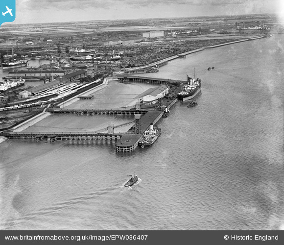
EPW036407 ENGLAND (1931). Boats moored at the West Wharf, the East Wharf and environs, Kingston upon Hull, from the south-west, 1931
© Hawlfraint cyfranwyr OpenStreetMap a thrwyddedwyd gan yr OpenStreetMap Foundation. 2026. Trwyddedir y gartograffeg fel CC BY-SA.
Delweddau cyfagos (6)
EPW036407

EPW010812

EPW036396

EPW036386

EAW004506

EPW036554

Manylion
| Pennawd | [EPW036407] Boats moored at the West Wharf, the East Wharf and environs, Kingston upon Hull, from the south-west, 1931 |
| Cyfeirnod | EPW036407 |
| Dyddiad | August-1931 |
| Dolen | |
| Enw lle | KINGSTON UPON HULL |
| Plwyf | |
| Ardal | |
| Gwlad | ENGLAND |
| Dwyreiniad / Gogleddiad | 511855, 428476 |
| Hydred / Lledred | -0.30387552726455, 53.740428598655 |
| Cyfeirnod Grid Cenedlaethol | TA119285 |
Pinnau
Byddwch y cyntaf i ychwanegu sylw at y ddelwedd hon!