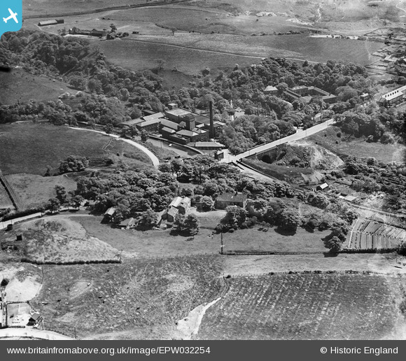
EPW032254 ENGLAND (1930). The Bardsley Vale Mills and Bardsley Bridge, Bardsley, 1930
© Hawlfraint cyfranwyr OpenStreetMap a thrwyddedwyd gan yr OpenStreetMap Foundation. 2026. Trwyddedir y gartograffeg fel CC BY-SA.
Delweddau cyfagos (12)
Manylion
| Pennawd | [EPW032254] The Bardsley Vale Mills and Bardsley Bridge, Bardsley, 1930 |
| Cyfeirnod | EPW032254 |
| Dyddiad | June-1930 |
| Dolen | |
| Enw lle | BARDSLEY |
| Plwyf | |
| Ardal | |
| Gwlad | ENGLAND |
| Dwyreiniad / Gogleddiad | 392999, 401385 |
| Hydred / Lledred | -2.1055762174526, 53.508855756382 |
| Cyfeirnod Grid Cenedlaethol | SD930014 |
Pinnau

stonecoldaustin |
Sunday 10th of November 2019 11:14:53 PM | |

John T. Pitman |
Thursday 16th of October 2014 12:04:54 AM | |

eddief |
Monday 2nd of September 2013 02:56:10 PM | |

eddief |
Monday 2nd of September 2013 02:50:14 PM | |

eddief |
Monday 2nd of September 2013 02:49:48 PM | |

eddief |
Monday 2nd of September 2013 02:44:56 PM | |

eddief |
Monday 2nd of September 2013 02:40:52 PM | |

eddief |
Monday 2nd of September 2013 02:39:51 PM | |

eddief |
Monday 2nd of September 2013 02:15:49 PM | |

eddief |
Monday 2nd of September 2013 02:15:16 PM |


![[EPW032254] The Bardsley Vale Mills and Bardsley Bridge, Bardsley, 1930](http://britainfromabove.org.uk/sites/all/libraries/aerofilms-images/public/100x100/EPW/032/EPW032254.jpg)
![[EPW032248] The Bardsley Vale Mills and Bardsley Bridge, Limehurst, 1930. This image has been produced from a damaged negative.](http://britainfromabove.org.uk/sites/all/libraries/aerofilms-images/public/100x100/EPW/032/EPW032248.jpg)
![[EPW032251] The Bardsley Vale Mills, Highfield Terrace and Bardsley Bridge, Limehurst, 1930. This image has been produced from a damaged negative.](http://britainfromabove.org.uk/sites/all/libraries/aerofilms-images/public/100x100/EPW/032/EPW032251.jpg)
![[EPW032255] The Bardsley Vale Mills and environs, Limehurst, 1930. This image has been produced from a damaged negative.](http://britainfromabove.org.uk/sites/all/libraries/aerofilms-images/public/100x100/EPW/032/EPW032255.jpg)
![[EPW032247] The Bardsley Vale Mills and Bardsley Bridge, Limehurst, 1930](http://britainfromabove.org.uk/sites/all/libraries/aerofilms-images/public/100x100/EPW/032/EPW032247.jpg)
![[EPW032253] The Bardsley Vale Mills, Bardsley Bridge and Valley Farm, Limehurst, 1930](http://britainfromabove.org.uk/sites/all/libraries/aerofilms-images/public/100x100/EPW/032/EPW032253.jpg)
![[EPW032257] The Bardsley Vale Mills and environs, Limehurst, 1930. This image has been produced from a damaged negative.](http://britainfromabove.org.uk/sites/all/libraries/aerofilms-images/public/100x100/EPW/032/EPW032257.jpg)
![[EPW032258] The Bardsley Vale Mills, Oldham Road and the Bardsley Brewery, Limehurst, 1930. This image has been affected by flare.](http://britainfromabove.org.uk/sites/all/libraries/aerofilms-images/public/100x100/EPW/032/EPW032258.jpg)
![[EPW032256] The Bardsley Vale Mills, the Stafford Works and Oldham Road, Limehurst, 1930. This image has been produced from a damaged negative.](http://britainfromabove.org.uk/sites/all/libraries/aerofilms-images/public/100x100/EPW/032/EPW032256.jpg)
![[EPW032249] The Bardsley Vale Mills, the Bardsley Brewery and Bardsley Bridge, Limehurst, 1930. This image has been produced from a damaged negative.](http://britainfromabove.org.uk/sites/all/libraries/aerofilms-images/public/100x100/EPW/032/EPW032249.jpg)
![[EAW004411] Wheatfield Iron Works, Bardsley,1947. This image was marked by Aerofilms Ltd for photo editing.](http://britainfromabove.org.uk/sites/all/libraries/aerofilms-images/public/100x100/EAW/004/EAW004411.jpg)
![[EAW004413] Wheatfield Iron Works, Bardsley, 1947. This image has been produced from a print marked by Aerofilms Ltd for photo editing.](http://britainfromabove.org.uk/sites/all/libraries/aerofilms-images/public/100x100/EAW/004/EAW004413.jpg)