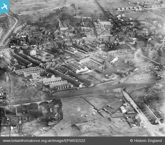
EPW031522 ENGLAND (1930). Horner Confectionery Works and the town centre, Chester-le-Street, 1930
© Hawlfraint cyfranwyr OpenStreetMap a thrwyddedwyd gan yr OpenStreetMap Foundation. 2026. Trwyddedir y gartograffeg fel CC BY-SA.
Delweddau cyfagos (15)
Manylion
| Pennawd | [EPW031522] Horner Confectionery Works and the town centre, Chester-le-Street, 1930 |
| Cyfeirnod | EPW031522 |
| Dyddiad | February-1930 |
| Dolen | |
| Enw lle | CHESTER-LE-STREET |
| Plwyf | |
| Ardal | |
| Gwlad | ENGLAND |
| Dwyreiniad / Gogleddiad | 427248, 551405 |
| Hydred / Lledred | -1.575510585681, 54.856605854822 |
| Cyfeirnod Grid Cenedlaethol | NZ272514 |
Pinnau

history group |
Monday 29th of April 2013 08:59:19 PM | |

history group |
Monday 29th of April 2013 08:58:28 PM | |

history group |
Monday 29th of April 2013 08:15:28 PM | |

Pelton Fell History Group |
Friday 19th of October 2012 11:38:15 AM | |

Pelton Fell History Group |
Friday 19th of October 2012 11:35:29 AM |
Cyfraniadau Grŵp

history group |
Friday 17th of January 2014 10:44:10 PM | |
Chester-le-Street in Roman Times There was a Roman fort at Chester-le-Street from around the second century AD until about 410 AD. The earliest fort was turf and timber,and was found under the later fort in a recent excavation. An inscription stone dated 216 AD is dispayed in a museum next to the parish church. The Roman Fort was to the east of Front Street. The parish church was later built in the middle of the fort. Middle Chare leads from the old Roman road (now Front Street) to the site of the fort and the parish church. |

history group |
Monday 29th of April 2013 08:57:27 PM |


![[EPW031522] Horner Confectionery Works and the town centre, Chester-le-Street, 1930](http://britainfromabove.org.uk/sites/all/libraries/aerofilms-images/public/100x100/EPW/031/EPW031522.jpg)
![[EPW031528] Horner Confectionery Works and environs, Chester-le-Street, 1930. This image has been affected by flare.](http://britainfromabove.org.uk/sites/all/libraries/aerofilms-images/public/100x100/EPW/031/EPW031528.jpg)
![[EPW031529] Horner Confectionery Works and environs, Chester-le-Street, 1930. This image has been affected by flare.](http://britainfromabove.org.uk/sites/all/libraries/aerofilms-images/public/100x100/EPW/031/EPW031529.jpg)
![[EPW031523] Horner Confectionery Works and the town centre, Chester-le-Street, 1930](http://britainfromabove.org.uk/sites/all/libraries/aerofilms-images/public/100x100/EPW/031/EPW031523.jpg)
![[EPW031525] Horner Confectionery Works and the town centre, Chester-le-Street, 1930](http://britainfromabove.org.uk/sites/all/libraries/aerofilms-images/public/100x100/EPW/031/EPW031525.jpg)
![[EPW014379] The Stag Confectionery Works, Chester-le-Street, 1925](http://britainfromabove.org.uk/sites/all/libraries/aerofilms-images/public/100x100/EPW/014/EPW014379.jpg)
![[EPW014381] The Stag Confectionery Works and environs, Chester-Le-Street, 1925. This image has been produced from a copy-negative.](http://britainfromabove.org.uk/sites/all/libraries/aerofilms-images/public/100x100/EPW/014/EPW014381.jpg)
![[EPW032775] The Horner Confectionery Works and the town centre, Chester-Le-Street, from the west, 1930. This image has been produced from a copy-negative.](http://britainfromabove.org.uk/sites/all/libraries/aerofilms-images/public/100x100/EPW/032/EPW032775.jpg)
![[EPW031527] Horner Confectionery Works and the town centre, Chester-le-Street, 1930](http://britainfromabove.org.uk/sites/all/libraries/aerofilms-images/public/100x100/EPW/031/EPW031527.jpg)
![[EPW031524] Horner Confectionery Works and the town centre, Chester-le-Street, 1930](http://britainfromabove.org.uk/sites/all/libraries/aerofilms-images/public/100x100/EPW/031/EPW031524.jpg)
![[EPW031526] Horner Confectionery Works and the town centre, Chester-le-Street, 1930](http://britainfromabove.org.uk/sites/all/libraries/aerofilms-images/public/100x100/EPW/031/EPW031526.jpg)
![[EPW032776] Horner's Dainty Dinah Toffee Factory and Chester Burn Viaduct, Chester-Le-Street, 1930. This image has been produced from a copy-negative.](http://britainfromabove.org.uk/sites/all/libraries/aerofilms-images/public/100x100/EPW/032/EPW032776.jpg)
![[EPW016429] The Stag Confectionery Works and the town centre, Chester-le-Street, 1926](http://britainfromabove.org.uk/sites/all/libraries/aerofilms-images/public/100x100/EPW/016/EPW016429.jpg)
![[EPW031530] Horner Confectionery Works and the town centre, Chester-le-Street, 1930](http://britainfromabove.org.uk/sites/all/libraries/aerofilms-images/public/100x100/EPW/031/EPW031530.jpg)
![[EPW014385] Chester Bridge and the surrounding area, Chester-Le-Street, 1925. This image has been produced from a copy-negative.](http://britainfromabove.org.uk/sites/all/libraries/aerofilms-images/public/100x100/EPW/014/EPW014385.jpg)
