
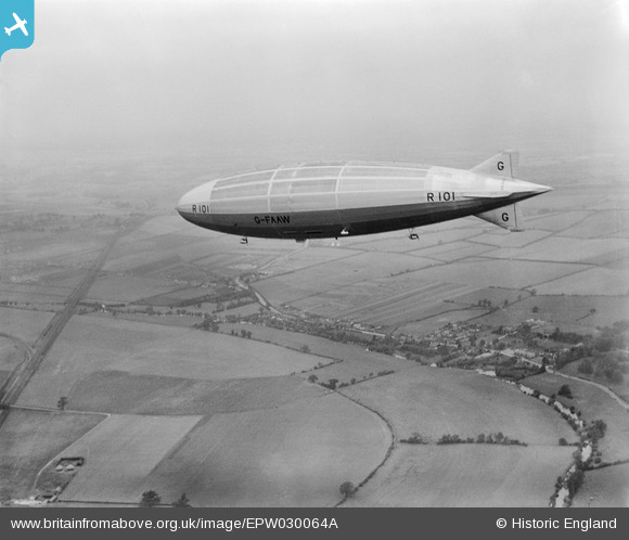
EPW030064A ENGLAND (1929). The R101 airship on its first test flight, Bromham, from the south-east, 1929
© Hawlfraint cyfranwyr OpenStreetMap a thrwyddedwyd gan yr OpenStreetMap Foundation. 2026. Trwyddedir y gartograffeg fel CC BY-SA.
Manylion
| Pennawd | [EPW030064A] The R101 airship on its first test flight, Bromham, from the south-east, 1929 |
| Cyfeirnod | EPW030064A |
| Dyddiad | 14-October-1929 |
| Dolen | |
| Enw lle | BROMHAM |
| Plwyf | BROMHAM |
| Ardal | |
| Gwlad | ENGLAND |
| Dwyreiniad / Gogleddiad | 503051, 252241 |
| Hydred / Lledred | -0.49339427362935, 52.158407174902 |
| Cyfeirnod Grid Cenedlaethol | TL031522 |
Pinnau

Chuzzle109 |
Wednesday 3rd of September 2014 06:58:55 PM | |

Class31 |
Saturday 27th of October 2012 05:04:10 PM | |
|
Class31 |
Saturday 27th of October 2012 05:01:42 PM | |
I agree that the houses shown are Clapham & not Bromham as in the title. Bromham is south west of this shot (off to the bottom left). |

melgibbs |
Saturday 13th of July 2013 08:38:11 PM |
Hi melgibbs, Thanks for commenting on the placename details. We have used "Bromham" because the grid reference for the image falls on the west side of the administrative area boundary that divides the civil parishes of Bromham and Clapham. The main subject of this air-to-air image is the airship, but that of course can't have a grid reference because it's flying. The geographic information for an image has to come from a reference on the ground. This is why air-to-air shots and photos of vessels at sea on the website, with no terrestrial points in them, have no grid reference or administrative area data. Although the settlement that you can see in the image is Clapham, the general area of the image foreground is in the parish of Bromham and this is where the grid reference falls. The village of Clapham is not in the civil parish of Bromham, so it would be misleading to have Clapham as the place name when the grid reference and administrative area information are for Bromham civil parish. This is an eternal problem cataloguing aerial photographs, because they can cover such very large areas. However, the beauty of the Britain from Above website is that pins posted onto the images can give more information than the basic, "technical", record! They can name and describe any building, hamlet, village or other feature to help visitors to the site to understand what they are seeing in each image. This is very valuable and we really rely on all our visitors and "virtual volunteers" to share their knowledge in this way. Yours, Katy Britain from Above Cataloguing Team Leader |
Katy Whitaker |
Friday 23rd of August 2013 11:35:08 AM |
|
Class31 |
Saturday 27th of October 2012 05:00:14 PM | |
Just north of this point, the track had a water trough between the rails so that express trains could scoop up water without stopping. |
melgibbs |
Saturday 13th of July 2013 08:32:49 PM |
|
Class31 |
Saturday 27th of October 2012 04:54:34 PM |
Cyfraniadau Grŵp
There is more on the R101 at http://en.wikipedia.org/wiki/R101. |
melgibbs |
Monday 9th of March 2015 06:42:01 PM |

10 photographs on britainfromabove.org |
Where's Canning Town? |
Wednesday 12th of February 2014 08:45:14 PM |