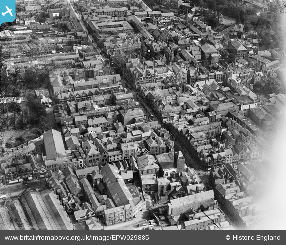
EPW029885 ENGLAND (1929). Eastgate Street and environs, Chester, 1929
© Hawlfraint cyfranwyr OpenStreetMap a thrwyddedwyd gan yr OpenStreetMap Foundation. 2026. Trwyddedir y gartograffeg fel CC BY-SA.
Delweddau cyfagos (26)
Manylion
| Pennawd | [EPW029885] Eastgate Street and environs, Chester, 1929 |
| Cyfeirnod | EPW029885 |
| Dyddiad | September-1929 |
| Dolen | |
| Enw lle | CHESTER |
| Plwyf | |
| Ardal | |
| Gwlad | ENGLAND |
| Dwyreiniad / Gogleddiad | 340612, 366328 |
| Hydred / Lledred | -2.8889418012967, 53.190434883097 |
| Cyfeirnod Grid Cenedlaethol | SJ406663 |
Pinnau

Class31 |
Friday 7th of August 2015 11:19:12 AM | |

London1955 |
Saturday 13th of July 2013 11:46:59 AM | |

London1955 |
Saturday 13th of July 2013 11:46:28 AM | |

Nic Clifton |
Monday 5th of November 2012 04:16:07 PM |


![[EPW029885] Eastgate Street and environs, Chester, 1929](http://britainfromabove.org.uk/sites/all/libraries/aerofilms-images/public/100x100/EPW/029/EPW029885.jpg)
![[EPW058002] The city centre, Chester, 1938. This image has been produced from a copy-negative.](http://britainfromabove.org.uk/sites/all/libraries/aerofilms-images/public/100x100/EPW/058/EPW058002.jpg)
![[EPW003097] The Cathedral Church of Christ and the Blessed Virgin Mary, Chester, 1920](http://britainfromabove.org.uk/sites/all/libraries/aerofilms-images/public/100x100/EPW/003/EPW003097.jpg)
![[EPW029881] Newgate Street and environs, Chester, 1929](http://britainfromabove.org.uk/sites/all/libraries/aerofilms-images/public/100x100/EPW/029/EPW029881.jpg)
![[EPW029883] The Cathedral Church of Christ and the Blessed Virgin Mary and environs, Chester, 1929](http://britainfromabove.org.uk/sites/all/libraries/aerofilms-images/public/100x100/EPW/029/EPW029883.jpg)
![[EPW037240] Foregate Street and the city centre, Chester, 1931](http://britainfromabove.org.uk/sites/all/libraries/aerofilms-images/public/100x100/EPW/037/EPW037240.jpg)
![[EPW040164] Bridge Street and the city centre, Chester, 1932](http://britainfromabove.org.uk/sites/all/libraries/aerofilms-images/public/100x100/EPW/040/EPW040164.jpg)
![[EPW029886] The Cathedral Church of Christ and the Blessed Virgin Mary and environs, Chester, 1929](http://britainfromabove.org.uk/sites/all/libraries/aerofilms-images/public/100x100/EPW/029/EPW029886.jpg)
![[EPW004003] The Cathedral Church of Christ and the Blessed Virgin Mary, Chester, 1920](http://britainfromabove.org.uk/sites/all/libraries/aerofilms-images/public/100x100/EPW/004/EPW004003.jpg)
![[EPW004006] The Cathedral Church of Christ and the Blessed Virgin Mary and the city, Chester, 1920. This image has been produced from a print.](http://britainfromabove.org.uk/sites/all/libraries/aerofilms-images/public/100x100/EPW/004/EPW004006.jpg)
![[EPW004008] The Cathedral Church of Christ and the Blessed Virgin Mary, Chester, 1920](http://britainfromabove.org.uk/sites/all/libraries/aerofilms-images/public/100x100/EPW/004/EPW004008.jpg)
![[EPW005885] Chester Cathedral, Chester, 1921. This image has been produced from a print.](http://britainfromabove.org.uk/sites/all/libraries/aerofilms-images/public/100x100/EPW/005/EPW005885.jpg)
![[EPW040162] Chester Cathedral and Market Square, Chester, 1932](http://britainfromabove.org.uk/sites/all/libraries/aerofilms-images/public/100x100/EPW/040/EPW040162.jpg)
![[EPW029884] Watergate Street and Eastgate Street, Chester, 1929](http://britainfromabove.org.uk/sites/all/libraries/aerofilms-images/public/100x100/EPW/029/EPW029884.jpg)
![[EPW058010] Chester Cathedral and the town centre, Chester, 1938](http://britainfromabove.org.uk/sites/all/libraries/aerofilms-images/public/100x100/EPW/058/EPW058010.jpg)
![[EPW037241] Eastgate Street and the city centre, Chester, 1931](http://britainfromabove.org.uk/sites/all/libraries/aerofilms-images/public/100x100/EPW/037/EPW037241.jpg)
![[EPW004007] The Cathedral Church of Christ and the Blessed Virgin Mary and environs, Chester, 1920. This image has been produced from a copy-negative.](http://britainfromabove.org.uk/sites/all/libraries/aerofilms-images/public/100x100/EPW/004/EPW004007.jpg)
![[EPW058007] The Cathedral Church of Christ and the Blessed Virgin Mary, Chester, 1938. This image has been produced from a copy-negative.](http://britainfromabove.org.uk/sites/all/libraries/aerofilms-images/public/100x100/EPW/058/EPW058007.jpg)
![[EPW005884] Bridge Street, Chester, 1921. This image has been produced from a copy-negative.](http://britainfromabove.org.uk/sites/all/libraries/aerofilms-images/public/100x100/EPW/005/EPW005884.jpg)
![[EPW011199] The Cathedral and city centre, Chester, 1924](http://britainfromabove.org.uk/sites/all/libraries/aerofilms-images/public/100x100/EPW/011/EPW011199.jpg)
![[EAW004377] The Cathedral Church of Christ and the Blessed Virgin Mary and environs, Chester, 1947](http://britainfromabove.org.uk/sites/all/libraries/aerofilms-images/public/100x100/EAW/004/EAW004377.jpg)
![[EPW058009] The city centre, Chester, 1938. This image has been produced from a print.](http://britainfromabove.org.uk/sites/all/libraries/aerofilms-images/public/100x100/EPW/058/EPW058009.jpg)
![[EPW029880] The Cathedral Church of Christ and the Blessed Virgin Mary and environs, Chester, 1929](http://britainfromabove.org.uk/sites/all/libraries/aerofilms-images/public/100x100/EPW/029/EPW029880.jpg)
![[EPW036909] Bridge Street and the city centre, Chester, from the south-east, 1931](http://britainfromabove.org.uk/sites/all/libraries/aerofilms-images/public/100x100/EPW/036/EPW036909.jpg)
![[EPW005883] The city, Chester, 1921. This image has been produced from a copy-negative.](http://britainfromabove.org.uk/sites/all/libraries/aerofilms-images/public/100x100/EPW/005/EPW005883.jpg)
![[EPW011200] The Cathedral and view of the city, Chester, from the west, 1924](http://britainfromabove.org.uk/sites/all/libraries/aerofilms-images/public/100x100/EPW/011/EPW011200.jpg)