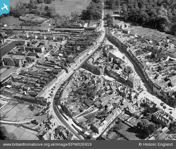
EPW026919 ENGLAND (1929). The town centre, Woodstock, 1929
© Hawlfraint cyfranwyr OpenStreetMap a thrwyddedwyd gan yr OpenStreetMap Foundation. 2026. Trwyddedir y gartograffeg fel CC BY-SA.
Delweddau cyfagos (8)
Manylion
| Pennawd | [EPW026919] The town centre, Woodstock, 1929 |
| Cyfeirnod | EPW026919 |
| Dyddiad | May-1929 |
| Dolen | |
| Enw lle | WOODSTOCK |
| Plwyf | WOODSTOCK |
| Ardal | |
| Gwlad | ENGLAND |
| Dwyreiniad / Gogleddiad | 444554, 216767 |
| Hydred / Lledred | -1.3531363190291, 51.847277706092 |
| Cyfeirnod Grid Cenedlaethol | SP446168 |
Pinnau

ndaisley |
Tuesday 10th of September 2013 05:07:41 PM |


![[EPW026919] The town centre, Woodstock, 1929](http://britainfromabove.org.uk/sites/all/libraries/aerofilms-images/public/100x100/EPW/026/EPW026919.jpg)
![[EPW026917] The town centre, Woodstock, 1929](http://britainfromabove.org.uk/sites/all/libraries/aerofilms-images/public/100x100/EPW/026/EPW026917.jpg)
![[EPW026916] St Mary's Church and the town centre, Woodstock, 1929](http://britainfromabove.org.uk/sites/all/libraries/aerofilms-images/public/100x100/EPW/026/EPW026916.jpg)
![[EPW026922] St Mary's Church and the town centre, Woodstock, 1929](http://britainfromabove.org.uk/sites/all/libraries/aerofilms-images/public/100x100/EPW/026/EPW026922.jpg)
![[EPW026918] St Mary's Church and the town centre, Woodstock, 1929](http://britainfromabove.org.uk/sites/all/libraries/aerofilms-images/public/100x100/EPW/026/EPW026918.jpg)
![[EPW026925] Woodstock railway station and environs, Woodstock, 1929](http://britainfromabove.org.uk/sites/all/libraries/aerofilms-images/public/100x100/EPW/026/EPW026925.jpg)
![[EAW014902] The village, Woodstock, from the south-west, 1948. This image has been produced from a print.](http://britainfromabove.org.uk/sites/all/libraries/aerofilms-images/public/100x100/EAW/014/EAW014902.jpg)
![[EPW026915] Woodstock House and environs, Woodstock, 1929](http://britainfromabove.org.uk/sites/all/libraries/aerofilms-images/public/100x100/EPW/026/EPW026915.jpg)