
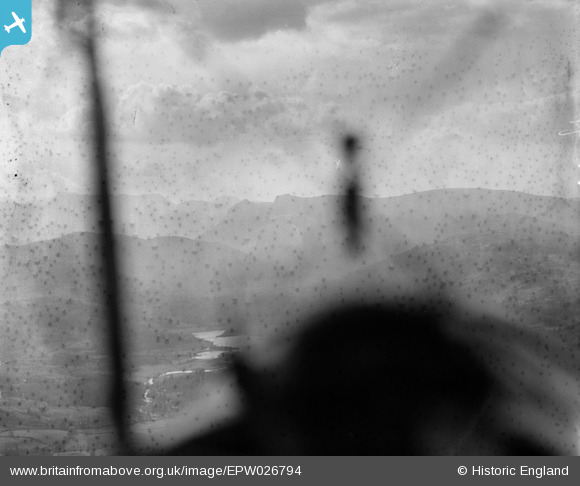
EPW026794 ENGLAND (1929). Elter Water and environs, Elterwater, from the south-east, 1929
© Hawlfraint cyfranwyr OpenStreetMap a thrwyddedwyd gan yr OpenStreetMap Foundation. 2026. Trwyddedir y gartograffeg fel CC BY-SA.
Delweddau cyfagos (2)
EPW026794

EPW026793

Manylion
| Pennawd | [EPW026794] Elter Water and environs, Elterwater, from the south-east, 1929 |
| Cyfeirnod | EPW026794 |
| Dyddiad | May-1929 |
| Dolen | |
| Enw lle | ELTERWATER |
| Plwyf | LAKES |
| Ardal | |
| Gwlad | ENGLAND |
| Dwyreiniad / Gogleddiad | 333988, 503569 |
| Hydred / Lledred | -3.0175158340998, 54.423124473942 |
| Cyfeirnod Grid Cenedlaethol | NY340036 |
Pinnau

Shugborough |
Sunday 10th of August 2014 03:24:33 PM | |
|
Shugborough |
Saturday 9th of August 2014 10:56:43 PM | |
|
Shugborough |
Saturday 9th of August 2014 10:56:17 PM | |
|
Shugborough |
Saturday 9th of August 2014 10:56:14 PM | |

Class31 |
Sunday 21st of October 2012 10:42:59 PM | |
|
Class31 |
Sunday 21st of October 2012 10:36:00 PM | |
|
Calchfaen |
Sunday 21st of October 2012 09:08:19 PM |
Cyfraniadau Grŵp
Pity there's almost more aeroplane than Lake District in shot! But it does indicate something about what it must have been like for Aerofilms Ltd photographers. We'll update the catalogue, and post the correct location data here in due course. Thank you! Yours, Katy Britain from Above Cataloguing Team Leader |
Katy Whitaker |
Wednesday 24th of October 2012 12:00:48 PM |
View looking west. |
Class31 |
Sunday 21st of October 2012 09:36:36 PM |
The pilot is flying over the English Lake District towards Langdale Pikes and is somewhere above the village of Skelwith Bridge. The sinuous course of the River Brathay and Elter water can be made out through the windshield. |
Calchfaen |
Sunday 21st of October 2012 09:07:24 PM |