
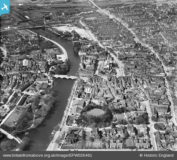
EPW026461 ENGLAND (1929). St Paul's Church and the town centre, Bedford, 1929
© Hawlfraint cyfranwyr OpenStreetMap a thrwyddedwyd gan yr OpenStreetMap Foundation. 2026. Trwyddedir y gartograffeg fel CC BY-SA.
Delweddau cyfagos (24)
EPW026461

EAW003718

EPW022386

EPW022383

EPW026472

EPW026465

EPW022387

EPW022388

EPW045603

EAW049227

EPW030066

EAW049226

EPW022391

EPW022379

EAW003716

EAW037738

EAW037739

EAW037740

EAW037749

EAW037741

EAW037742

EAW037743

EAW037760

EAW037761

Manylion
| Pennawd | [EPW026461] St Paul's Church and the town centre, Bedford, 1929 |
| Cyfeirnod | EPW026461 |
| Dyddiad | May-1929 |
| Dolen | |
| Enw lle | BEDFORD |
| Plwyf | |
| Ardal | |
| Gwlad | ENGLAND |
| Dwyreiniad / Gogleddiad | 505052, 249627 |
| Hydred / Lledred | -0.46495923720367, 52.134534602052 |
| Cyfeirnod Grid Cenedlaethol | TL051496 |
Pinnau
 |

melgibbs |
Sunday 27th of August 2017 06:45:05 PM |
 |
melgibbs |
Tuesday 29th of December 2015 03:25:00 PM |
 |
melgibbs |
Sunday 6th of September 2015 03:54:43 PM |
 |
melgibbs |
Friday 28th of August 2015 04:40:07 PM |
 |
melgibbs |
Monday 23rd of March 2015 04:23:00 PM |
|
melgibbs |
Tuesday 17th of March 2015 07:47:48 PM | |
 |
melgibbs |
Saturday 7th of February 2015 04:16:04 PM |
 |
melgibbs |
Friday 6th of February 2015 07:27:44 PM |
 |
melgibbs |
Friday 20th of December 2013 06:45:42 PM |
 |
melgibbs |
Friday 20th of December 2013 06:42:16 PM |
CORRECTION - I've reread the Latin inscription and noticed I misread the f's & s's and some of the puctuation so I think the Latin is: Ecce viator! Corporea Effigies Gulielmi harpur, Equitis Aurati, Scholce istius. Quam cernis amplam et ornatam Munificentissimi Fundatoris. Si ANIMOE Picturam fpectare velis, In Charta Beneficiorum invenias Delinia tam. Google translates this as: See traveler! Corporeal Portrait of William Harpur, Knight, schools of that. What you see is a wide and equipped with generous founder. If you want sympathy and skilful painting, The Charter of the benefits you will find charms as well. |
melgibbs |
Wednesday 25th of December 2013 09:48:04 AM |
|
melgibbs |
Thursday 19th of December 2013 05:56:13 PM | |
|
melgibbs |
Thursday 19th of December 2013 05:50:12 PM | |
|
melgibbs |
Thursday 19th of December 2013 05:05:50 PM | |
|
melgibbs |
Thursday 19th of December 2013 05:03:29 PM | |
|
melgibbs |
Monday 9th of December 2013 10:47:30 AM | |
 |
melgibbs |
Monday 9th of December 2013 10:46:20 AM |
 |
melgibbs |
Monday 9th of December 2013 10:42:08 AM |
|
melgibbs |
Wednesday 20th of November 2013 09:55:21 PM | |
|
melgibbs |
Wednesday 20th of November 2013 09:51:18 PM | |
|
melgibbs |
Wednesday 20th of November 2013 09:50:24 PM | |
|
melgibbs |
Tuesday 11th of June 2013 08:00:44 PM | |
|
melgibbs |
Tuesday 11th of June 2013 07:59:02 PM | |
|
melgibbs |
Tuesday 11th of June 2013 07:56:38 PM | |
|
melgibbs |
Tuesday 11th of June 2013 07:55:26 PM | |
|
melgibbs |
Tuesday 11th of June 2013 07:53:47 PM | |
|
melgibbs |
Tuesday 11th of June 2013 07:24:24 PM | |
|
melgibbs |
Tuesday 11th of June 2013 07:20:25 PM | |
|
melgibbs |
Tuesday 11th of June 2013 07:19:40 PM | |
|
melgibbs |
Tuesday 11th of June 2013 07:19:17 PM | |
|
melgibbs |
Tuesday 11th of June 2013 07:18:11 PM | |
|
melgibbs |
Tuesday 11th of June 2013 07:16:53 PM | |
|
melgibbs |
Tuesday 11th of June 2013 07:16:24 PM | |
|
melgibbs |
Tuesday 11th of June 2013 07:16:02 PM | |
|
melgibbs |
Tuesday 11th of June 2013 07:15:38 PM | |
|
melgibbs |
Tuesday 11th of June 2013 07:15:16 PM | |
|
melgibbs |
Tuesday 11th of June 2013 07:14:27 PM | |
|
melgibbs |
Tuesday 4th of June 2013 10:36:05 AM | |

Class31 |
Saturday 27th of October 2012 10:00:10 PM | |
|
Class31 |
Saturday 27th of October 2012 09:58:45 PM | |
The 1924 map of Bedford has this stretch of road named as Cauldwell Road and becomes Prebend Street after the Commercial Road junction, but the whole length of road between Cauldwell Street corner and Midland Road is now called Prebend Street. |
melgibbs |
Saturday 22nd of June 2013 08:06:56 PM |
|
Class31 |
Saturday 27th of October 2012 09:57:53 PM | |
|
Class31 |
Saturday 27th of October 2012 09:56:29 PM | |
|
Class31 |
Saturday 27th of October 2012 09:55:58 PM | |
|
Class31 |
Saturday 27th of October 2012 09:54:08 PM | |
|
Class31 |
Saturday 27th of October 2012 09:53:44 PM | |
|
Class31 |
Saturday 27th of October 2012 09:53:24 PM | |
|
Class31 |
Saturday 27th of October 2012 09:53:03 PM | |
|
Class31 |
Saturday 27th of October 2012 09:52:38 PM | |
|
Class31 |
Saturday 27th of October 2012 09:52:19 PM |

Cyfraniadau Grŵp

The Holy Child & St Joseph R C Church, Bedford, 02/06/2014 |
Class31 |
Sunday 22nd of March 2015 08:20:34 PM |