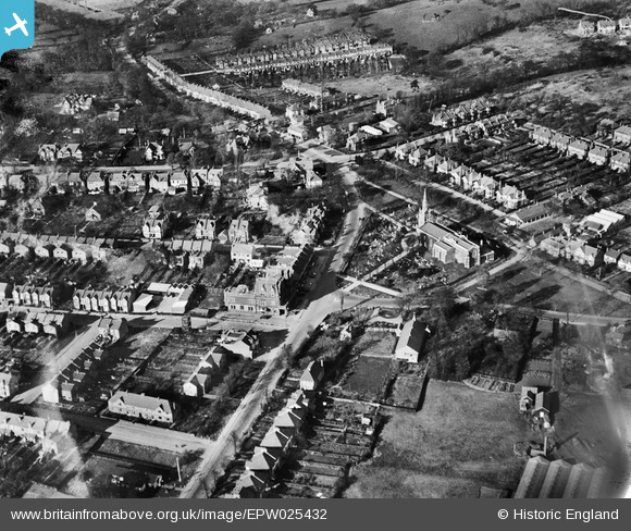
EPW025432 ENGLAND (1928). St Peter and St Paul's Church and The Green, Chingford Green, 1928
    © Hawlfraint cyfranwyr OpenStreetMap a thrwyddedwyd gan yr OpenStreetMap Foundation. 2025. Trwyddedir y gartograffeg fel CC BY-SA.
  
Delweddau cyfagos (5)
Manylion
| Pennawd | [EPW025432] St Peter and St Paul's Church and The Green, Chingford Green, 1928 | 
| Cyfeirnod | EPW025432 | 
| Dyddiad | 8-December-1928 | 
| Dolen | |
| Enw lle | CHINGFORD GREEN | 
| Plwyf | |
| Ardal | |
| Gwlad | ENGLAND | 
| Dwyreiniad / Gogleddiad | 538546, 194331 | 
| Hydred / Lledred | 0.0019695385377297, 51.630241060672 | 
| Cyfeirnod Grid Cenedlaethol | TQ385943 | 
 
             
  ![[EPW025432] St Peter and St Paul's Church and The Green, Chingford Green, 1928](http://britainfromabove.org.uk/sites/all/libraries/aerofilms-images/public/100x100/EPW/025/EPW025432.jpg) 
  
                                          ![[EPW025426] St Peter & St Paul's Church and environs, Chingford, 1928. This image has been produced from a print.](http://britainfromabove.org.uk/sites/all/libraries/aerofilms-images/public/100x100/EPW/025/EPW025426.jpg) 
 ![[EPW025366] St Peter and St Paul's Church and Chingford Green, Chingford, 1928](http://britainfromabove.org.uk/sites/all/libraries/aerofilms-images/public/100x100/EPW/025/EPW025366.jpg) 
 ![[EPW025431] The Green and environs, Chingford Green, 1928](http://britainfromabove.org.uk/sites/all/libraries/aerofilms-images/public/100x100/EPW/025/EPW025431.jpg) 
 ![[EPW025368] Chingford and surrounding countryside, Chingford, from the south, 1928](http://britainfromabove.org.uk/sites/all/libraries/aerofilms-images/public/100x100/EPW/025/EPW025368.jpg) 
  Kings Head Hill
 Kings Head Hill