
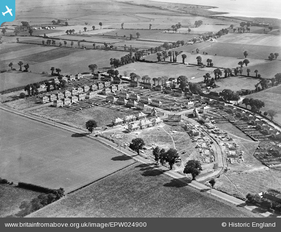
EPW024900 ENGLAND (1928). New housing under construction between Corringham Road and Billet Lane, Stanford-le-Hope, 1928
© Hawlfraint cyfranwyr OpenStreetMap a thrwyddedwyd gan yr OpenStreetMap Foundation. 2026. Trwyddedir y gartograffeg fel CC BY-SA.
Delweddau cyfagos (5)
EPW024900

EPW024903

EPW024905

EAW024610

EAW024611

Manylion
| Pennawd | [EPW024900] New housing under construction between Corringham Road and Billet Lane, Stanford-le-Hope, 1928 |
| Cyfeirnod | EPW024900 |
| Dyddiad | 3-October-1928 |
| Dolen | |
| Enw lle | STANFORD-LE-HOPE |
| Plwyf | |
| Ardal | |
| Gwlad | ENGLAND |
| Dwyreiniad / Gogleddiad | 569358, 182415 |
| Hydred / Lledred | 0.44105751183526, 51.51475423911 |
| Cyfeirnod Grid Cenedlaethol | TQ694824 |
Pinnau

Corringham Light Railway |
Tuesday 17th of December 2024 08:02:00 PM | |
|
Corringham Light Railway |
Thursday 4th of August 2022 11:16:42 AM | |

Bandon |
Friday 15th of January 2021 04:38:09 PM | |
|
Bandon |
Friday 27th of November 2020 04:51:50 PM | |
|
Ferina |
Saturday 28th of June 2014 04:29:11 PM | |
|
BigglesH |
Monday 16th of July 2012 09:07:12 PM | |
|
BigglesH |
Monday 16th of July 2012 09:06:07 PM | |
|
BigglesH |
Monday 16th of July 2012 09:05:15 PM |
Cyfraniadau Grŵp
Photo taken from Northwest. See also EPW024903 & EPW024905. |
BigglesH |
Monday 16th of July 2012 09:34:48 PM |