
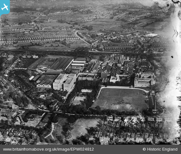
EPW024812 ENGLAND (1928). The Bournville Cocoa and Chocolate Works and environs, Bournville, 1928. This image has been produced from a damaged negative.
© Hawlfraint cyfranwyr OpenStreetMap a thrwyddedwyd gan yr OpenStreetMap Foundation. 2026. Trwyddedir y gartograffeg fel CC BY-SA.
Delweddau cyfagos (26)
EPW024812

EPW001104

EPW024798

EPW024799

EPW024801

EPW024796

EPW024810

EPW001237

EPW024805

EPW024800

EPW005071

EPW005072

EPW024808

EPW024809

EPW024811

EPW024797

EPW024802

EPW024803

EPW024804

EPW001238

EPW024806

EPW022580

EPW022579

EPW022578

EPW001232

EPW005073

Manylion
| Pennawd | [EPW024812] The Bournville Cocoa and Chocolate Works and environs, Bournville, 1928. This image has been produced from a damaged negative. |
| Cyfeirnod | EPW024812 |
| Dyddiad | September-1928 |
| Dolen | |
| Enw lle | BOURNVILLE |
| Plwyf | |
| Ardal | |
| Gwlad | ENGLAND |
| Dwyreiniad / Gogleddiad | 404782, 281208 |
| Hydred / Lledred | -1.9296626719662, 52.428458297415 |
| Cyfeirnod Grid Cenedlaethol | SP048812 |
Pinnau
Byddwch y cyntaf i ychwanegu sylw at y ddelwedd hon!