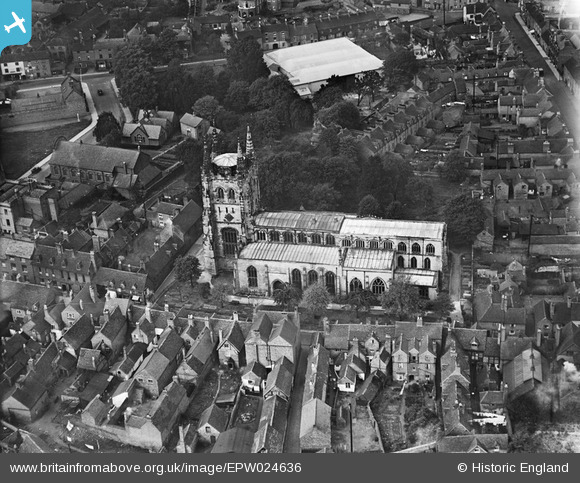
EPW024636 ENGLAND (1928). St Editha's Church, Tamworth, 1928
© Hawlfraint cyfranwyr OpenStreetMap a thrwyddedwyd gan yr OpenStreetMap Foundation. 2025. Trwyddedir y gartograffeg fel CC BY-SA.
Delweddau cyfagos (17)
Manylion
| Pennawd | [EPW024636] St Editha's Church, Tamworth, 1928 |
| Cyfeirnod | EPW024636 |
| Dyddiad | October-1928 |
| Dolen | |
| Enw lle | TAMWORTH |
| Plwyf | |
| Ardal | |
| Gwlad | ENGLAND |
| Dwyreiniad / Gogleddiad | 420776, 304085 |
| Hydred / Lledred | -1.6929818155903, 52.633766954584 |
| Cyfeirnod Grid Cenedlaethol | SK208041 |
Pinnau

Chris Gibson |
Monday 16th of December 2019 12:23:44 AM | |

tamworthhistoryinphotos |
Wednesday 11th of November 2015 10:51:27 AM | |

Andrew Sandars |
Tuesday 13th of January 2015 08:04:11 PM | |

Chris Gibson |
Saturday 20th of October 2012 12:51:01 PM | |

Chris Gibson |
Saturday 20th of October 2012 12:33:28 PM | |

Angella |
Monday 30th of July 2012 08:43:28 PM | |

Angella |
Monday 30th of July 2012 08:41:24 PM | |

Angella |
Monday 30th of July 2012 08:41:01 PM | |

Angella |
Monday 30th of July 2012 08:40:40 PM |
Cyfraniadau Grŵp

Church Street |

tamworthhistoryinphotos |
Wednesday 11th of November 2015 10:48:05 AM |
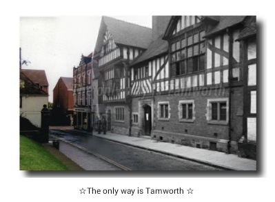
I have this photo on my group Tamworth history in photos |

lendl43@aol.co.uk |
Saturday 27th of October 2012 11:02:58 AM |


![[EPW024636] St Editha's Church, Tamworth, 1928](http://britainfromabove.org.uk/sites/all/libraries/aerofilms-images/public/100x100/EPW/024/EPW024636.jpg)
![[EPW024637] The Market Place and Town Hall, Tamworth, 1928](http://britainfromabove.org.uk/sites/all/libraries/aerofilms-images/public/100x100/EPW/024/EPW024637.jpg)
![[EPW019733] Tamworth Castle and St Editha's Church, Tamworth, 1927](http://britainfromabove.org.uk/sites/all/libraries/aerofilms-images/public/100x100/EPW/019/EPW019733.jpg)
![[EPW019734] St Editha's Church and Church Street, Tamworth, 1927](http://britainfromabove.org.uk/sites/all/libraries/aerofilms-images/public/100x100/EPW/019/EPW019734.jpg)
![[EAW003618] The castle and environs, Tamworth, 1947](http://britainfromabove.org.uk/sites/all/libraries/aerofilms-images/public/100x100/EAW/003/EAW003618.jpg)
![[EAW003616] The castle and environs, Tamworth, 1947](http://britainfromabove.org.uk/sites/all/libraries/aerofilms-images/public/100x100/EAW/003/EAW003616.jpg)
![[EAW007512] Tamworth Castle, Tamworth, 1947. This image has been produced from a print.](http://britainfromabove.org.uk/sites/all/libraries/aerofilms-images/public/100x100/EAW/007/EAW007512.jpg)
![[EAW007510] Tamworth Castle, Tamworth, 1947](http://britainfromabove.org.uk/sites/all/libraries/aerofilms-images/public/100x100/EAW/007/EAW007510.jpg)
![[EAW003617] The castle and environs, Tamworth, 1947](http://britainfromabove.org.uk/sites/all/libraries/aerofilms-images/public/100x100/EAW/003/EAW003617.jpg)
![[EAW007514] Tamworth Castle and environs, Tamworth, 1947. This image has been produced from a print.](http://britainfromabove.org.uk/sites/all/libraries/aerofilms-images/public/100x100/EAW/007/EAW007514.jpg)
![[EAW007509] Tamworth Castle, Tamworth, 1947](http://britainfromabove.org.uk/sites/all/libraries/aerofilms-images/public/100x100/EAW/007/EAW007509.jpg)
![[EPW019732] Tamworth Castle and St Editha's Church, Tamworth, 1927](http://britainfromabove.org.uk/sites/all/libraries/aerofilms-images/public/100x100/EPW/019/EPW019732.jpg)
![[EAW007511] Tamworth Castle, Tamworth, 1947. This image has been produced from a print.](http://britainfromabove.org.uk/sites/all/libraries/aerofilms-images/public/100x100/EAW/007/EAW007511.jpg)
![[EPW019731] Lady Bridge and Tamworth Castle, Tamworth, 1927](http://britainfromabove.org.uk/sites/all/libraries/aerofilms-images/public/100x100/EPW/019/EPW019731.jpg)
![[EAW007508] Tamworth Castle, Tamworth, 1947](http://britainfromabove.org.uk/sites/all/libraries/aerofilms-images/public/100x100/EAW/007/EAW007508.jpg)
![[EPW024630] Tamworth Castle and the town centre, Tamworth, 1928](http://britainfromabove.org.uk/sites/all/libraries/aerofilms-images/public/100x100/EPW/024/EPW024630.jpg)
![[EAW007513] Lady Bridge and Tamworth Castle, Tamworth, 1947. This image has been produced from a print.](http://britainfromabove.org.uk/sites/all/libraries/aerofilms-images/public/100x100/EAW/007/EAW007513.jpg)

