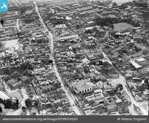
EPW024169 ENGLAND (1928). Westgate Street, Eastgate Street and the town centre, Gloucester, 1928
© Hawlfraint cyfranwyr OpenStreetMap a thrwyddedwyd gan yr OpenStreetMap Foundation. 2026. Trwyddedir y gartograffeg fel CC BY-SA.
Delweddau cyfagos (26)
Manylion
| Pennawd | [EPW024169] Westgate Street, Eastgate Street and the town centre, Gloucester, 1928 |
| Cyfeirnod | EPW024169 |
| Dyddiad | September-1928 |
| Dolen | |
| Enw lle | GLOUCESTER |
| Plwyf | |
| Ardal | |
| Gwlad | ENGLAND |
| Dwyreiniad / Gogleddiad | 383088, 218560 |
| Hydred / Lledred | -2.2456343176093, 51.864922313418 |
| Cyfeirnod Grid Cenedlaethol | SO831186 |
Pinnau

marcus |
Sunday 5th of May 2013 09:27:15 PM | |

marcus |
Sunday 5th of May 2013 09:25:10 PM | |

marcus |
Sunday 5th of May 2013 09:23:52 PM | |

Class31 |
Tuesday 16th of October 2012 11:16:52 AM | |

Class31 |
Tuesday 16th of October 2012 11:15:46 AM | |

Class31 |
Tuesday 16th of October 2012 11:13:05 AM | |

Class31 |
Tuesday 16th of October 2012 11:11:46 AM | |

Trebor |
Tuesday 28th of August 2012 09:54:24 AM | |

Trebor |
Tuesday 28th of August 2012 09:53:37 AM | |

Trebor |
Tuesday 28th of August 2012 09:46:34 AM | |

gannett |
Saturday 7th of July 2012 02:11:27 PM |
Cyfraniadau Grŵp
Eastgate Street looking north west 27/09/2013 |

Class31 |
Monday 30th of September 2013 07:09:43 PM |
St Michaels church at the cross still has it's C19th nave, and the eastgate indoor market buildings can be seen east of that. most notable it's the roofscape - premodern, flat roofs and mscps. Next, you see the lanes, parallel with and behind the main streets, with their, often since lost, numerous enfronting buildings. The void that became the c20th Kings sq is there, and you can make out many still extant build ins, including the New Inn on Northgate Street. |

Ian Williams |
Tuesday 26th of June 2012 01:02:52 PM |


![[EPW024169] Westgate Street, Eastgate Street and the town centre, Gloucester, 1928](http://britainfromabove.org.uk/sites/all/libraries/aerofilms-images/public/100x100/EPW/024/EPW024169.jpg)
![[EAW000728] Northgate Street, Southgate Street and environs, Gloucester, 1946](http://britainfromabove.org.uk/sites/all/libraries/aerofilms-images/public/100x100/EAW/000/EAW000728.jpg)
![[EPW037835] The city centre and docks, Gloucester, 1932](http://britainfromabove.org.uk/sites/all/libraries/aerofilms-images/public/100x100/EPW/037/EPW037835.jpg)
![[EAW018729] The city, Gloucester, 1948. This image has been produced from a print.](http://britainfromabove.org.uk/sites/all/libraries/aerofilms-images/public/100x100/EAW/018/EAW018729.jpg)
![[EAW000727] Holy Trinity Cathedral and the city, Gloucester, 1946](http://britainfromabove.org.uk/sites/all/libraries/aerofilms-images/public/100x100/EAW/000/EAW000727.jpg)
![[EAW000726] The city, Gloucester, from the south-west, 1946](http://britainfromabove.org.uk/sites/all/libraries/aerofilms-images/public/100x100/EAW/000/EAW000726.jpg)
![[EPW024165] Holy Trinity Cathedral and the town centre, Gloucester, 1928](http://britainfromabove.org.uk/sites/all/libraries/aerofilms-images/public/100x100/EPW/024/EPW024165.jpg)
![[EPW024106] The city centre, Gloucester, from the south-west, 1928](http://britainfromabove.org.uk/sites/all/libraries/aerofilms-images/public/100x100/EPW/024/EPW024106.jpg)
![[EAW003566] Gloucester Cathedral, Gloucester, 1947](http://britainfromabove.org.uk/sites/all/libraries/aerofilms-images/public/100x100/EAW/003/EAW003566.jpg)
![[EAW003565] Gloucester Cathedral, Gloucester, 1947](http://britainfromabove.org.uk/sites/all/libraries/aerofilms-images/public/100x100/EAW/003/EAW003565.jpg)
![[EPW024163] Holy Trinity Cathedral and the town centre, Gloucester, 1928. This image was marked by Aerofilms Ltd for photo editing.](http://britainfromabove.org.uk/sites/all/libraries/aerofilms-images/public/100x100/EPW/024/EPW024163.jpg)
![[EAW000730] Westgate Street, Holy Trinity Cathedral and environs, Gloucester, 1946](http://britainfromabove.org.uk/sites/all/libraries/aerofilms-images/public/100x100/EAW/000/EAW000730.jpg)
![[EPW006016] The city centre, Gloucester, 1921. This image has been produced from a copy-negative.](http://britainfromabove.org.uk/sites/all/libraries/aerofilms-images/public/100x100/EPW/006/EPW006016.jpg)
![[EPW024152] Holy Trinity Catheral and environs, Gloucester, 1928](http://britainfromabove.org.uk/sites/all/libraries/aerofilms-images/public/100x100/EPW/024/EPW024152.jpg)
![[EPW024155] Holy Trinity Catheral and environs, Gloucester, 1928](http://britainfromabove.org.uk/sites/all/libraries/aerofilms-images/public/100x100/EPW/024/EPW024155.jpg)
![[EPW006011] Holy Trinity Cathedral, Gloucester, 1921](http://britainfromabove.org.uk/sites/all/libraries/aerofilms-images/public/100x100/EPW/006/EPW006011.jpg)
![[EPW024158] Holy Trinity Cathedral and environs, Gloucester, 1928](http://britainfromabove.org.uk/sites/all/libraries/aerofilms-images/public/100x100/EPW/024/EPW024158.jpg)
![[EAW003567] Gloucester Cathedral, Gloucester, 1947](http://britainfromabove.org.uk/sites/all/libraries/aerofilms-images/public/100x100/EAW/003/EAW003567.jpg)
![[EAW032304] Holy Trinity Cathedral, Westgate Street and environs, Gloucester, 1950](http://britainfromabove.org.uk/sites/all/libraries/aerofilms-images/public/100x100/EAW/032/EAW032304.jpg)
![[EAW003569] Gloucester Cathedral, Gloucester, 1947](http://britainfromabove.org.uk/sites/all/libraries/aerofilms-images/public/100x100/EAW/003/EAW003569.jpg)
![[EPW041487] The Cathedral Church of St Peter and the Holy Family, Gloucester, 1933](http://britainfromabove.org.uk/sites/all/libraries/aerofilms-images/public/100x100/EPW/041/EPW041487.jpg)
![[EAW003568] Gloucester Cathedral, Gloucester, 1947](http://britainfromabove.org.uk/sites/all/libraries/aerofilms-images/public/100x100/EAW/003/EAW003568.jpg)
![[EAW032306] Holy Trinity Cathedral, Gloucester, 1950](http://britainfromabove.org.uk/sites/all/libraries/aerofilms-images/public/100x100/EAW/032/EAW032306.jpg)
![[EAW032305] Holy Trinity Cathedral, Gloucester, 1950](http://britainfromabove.org.uk/sites/all/libraries/aerofilms-images/public/100x100/EAW/032/EAW032305.jpg)
![[EAW000729] Westgate Street, Holy Trinity Cathedral and environs, Gloucester, 1946](http://britainfromabove.org.uk/sites/all/libraries/aerofilms-images/public/100x100/EAW/000/EAW000729.jpg)
![[EAW018730] The city and docks, Gloucester, 1948. This image has been produced from a print.](http://britainfromabove.org.uk/sites/all/libraries/aerofilms-images/public/100x100/EAW/018/EAW018730.jpg)