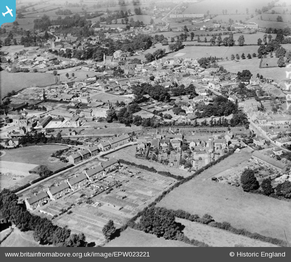
EPW023221 ENGLAND (1928). Gillingham and environs, Gillingham, from the south-east, 1928
© Hawlfraint cyfranwyr OpenStreetMap a thrwyddedwyd gan yr OpenStreetMap Foundation. 2026. Trwyddedir y gartograffeg fel CC BY-SA.
Delweddau cyfagos (3)
EPW023221

EPW023218

EPW033729

Manylion
| Pennawd | [EPW023221] Gillingham and environs, Gillingham, from the south-east, 1928 |
| Cyfeirnod | EPW023221 |
| Dyddiad | September-1928 |
| Dolen | |
| Enw lle | GILLINGHAM |
| Plwyf | GILLINGHAM |
| Ardal | |
| Gwlad | ENGLAND |
| Dwyreiniad / Gogleddiad | 381201, 126073 |
| Hydred / Lledred | -2.2681251862495, 51.033173909406 |
| Cyfeirnod Grid Cenedlaethol | ST812261 |
Pinnau

Class31 |
Wednesday 16th of September 2015 04:54:12 PM | |

burntbacon |
Saturday 30th of May 2015 09:18:45 PM | |
|
Jaz |
Wednesday 29th of May 2013 10:12:49 PM | |
|
Jaz |
Wednesday 29th of May 2013 10:12:11 PM | |
|
Jaz |
Wednesday 29th of May 2013 10:11:35 PM | |
|
Class31 |
Wednesday 1st of August 2012 10:18:45 AM | |
|
Class31 |
Wednesday 1st of August 2012 10:18:09 AM | |
|
Class31 |
Wednesday 1st of August 2012 10:17:20 AM | |
|
Class31 |
Wednesday 1st of August 2012 10:16:56 AM | |
|
Class31 |
Wednesday 1st of August 2012 10:16:12 AM | |
|
Class31 |
Wednesday 1st of August 2012 10:15:40 AM | |
|
Class31 |
Wednesday 1st of August 2012 10:15:15 AM |