
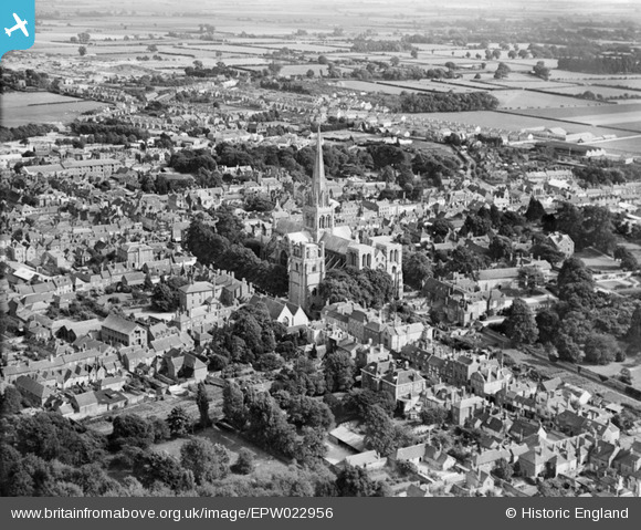
EPW022956 ENGLAND (1928). Chichester Cathedral and environs, Chichester, 1928
© Hawlfraint cyfranwyr OpenStreetMap a thrwyddedwyd gan yr OpenStreetMap Foundation. 2026. Trwyddedir y gartograffeg fel CC BY-SA.
Delweddau cyfagos (25)
EPW022956

EPW000661

EPW057432

EAW018179

EAW006596

EPW011552

EPW011550

EPW022960

EPW022958

EPW000231

EPW022957

EPW022959

EPW000230

EAW029568

EAW028277

EPW001491

EAW026212

EAW028774

EPW000232

EAW028775

EPW000664

EPW000662

EPW000663

EAW018182

EAW026211

Manylion
| Pennawd | [EPW022956] Chichester Cathedral and environs, Chichester, 1928 |
| Cyfeirnod | EPW022956 |
| Dyddiad | August-1928 |
| Dolen | |
| Enw lle | CHICHESTER |
| Plwyf | CHICHESTER |
| Ardal | |
| Gwlad | ENGLAND |
| Dwyreiniad / Gogleddiad | 485901, 104826 |
| Hydred / Lledred | -0.7799682382486, 50.836021513284 |
| Cyfeirnod Grid Cenedlaethol | SU859048 |
Pinnau

David960 |
Friday 23rd of January 2015 08:09:37 PM | |
|
David960 |
Friday 23rd of January 2015 08:07:57 PM | |
|
David960 |
Friday 23rd of January 2015 08:07:06 PM | |
|
David960 |
Friday 23rd of January 2015 07:58:37 PM | |
|
David960 |
Friday 23rd of January 2015 07:57:57 PM | |
|
David960 |
Friday 23rd of January 2015 07:57:15 PM | |

Class31 |
Monday 18th of August 2014 07:58:42 PM | |

Alan McFaden |
Monday 25th of November 2013 06:04:18 PM | |
|
Alan McFaden |
Monday 25th of November 2013 06:03:39 PM | |
|
Alan McFaden |
Wednesday 25th of September 2013 05:33:49 PM | |
|
Alan McFaden |
Wednesday 25th of September 2013 05:33:16 PM | |
|
Steve Anscombe |
Friday 21st of September 2012 08:03:57 PM |


Cyfraniadau Grŵp
Taken from the north-west quarter; cliched it may be but I can see my (old) house from here. The pin marks the then fledgling boys high school - in Kingsham Road; it opened for business in 1928. My walk to school took some 2 minutes - though not in 1928, I was there in the 70s The ramrod straight row of houses opposite were council built and linked with Kingsham Avenue almost at the point at which the cathedral spire peaks in the picture; the union of the two being marked by the local co-operative society dairy. |
Steve Anscombe |
Friday 21st of September 2012 09:09:31 PM |