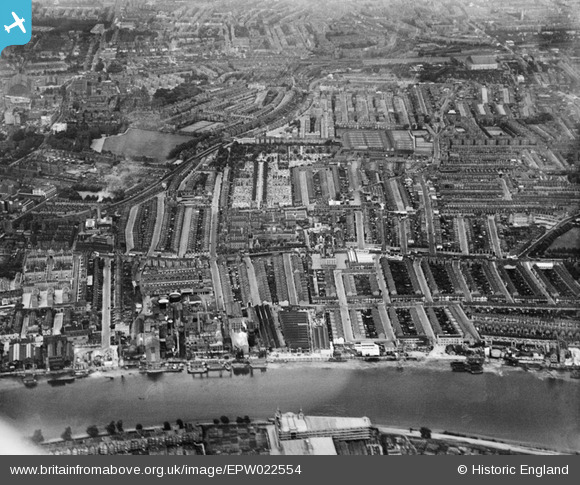
EPW022554 ENGLAND (1928). Fulham Palace Road and environs, Fulham, from the west, 1928
© Hawlfraint cyfranwyr OpenStreetMap a thrwyddedwyd gan yr OpenStreetMap Foundation. 2026. Trwyddedir y gartograffeg fel CC BY-SA.
Delweddau cyfagos (22)
Manylion
| Pennawd | [EPW022554] Fulham Palace Road and environs, Fulham, from the west, 1928 |
| Cyfeirnod | EPW022554 |
| Dyddiad | August-1928 |
| Dolen | |
| Enw lle | FULHAM |
| Plwyf | |
| Ardal | |
| Gwlad | ENGLAND |
| Dwyreiniad / Gogleddiad | 523409, 177804 |
| Hydred / Lledred | -0.22243917351182, 51.485219931305 |
| Cyfeirnod Grid Cenedlaethol | TQ234778 |
Pinnau

Danno |
Saturday 4th of April 2020 10:56:09 AM | |

Danno |
Saturday 4th of April 2020 10:26:51 AM | |

bondi |
Saturday 20th of December 2014 03:04:02 PM | |

bondi |
Saturday 20th of December 2014 02:22:41 PM | |

bondi |
Saturday 20th of December 2014 02:20:03 PM | |

Class31 |
Monday 29th of September 2014 05:10:05 PM | |

Class31 |
Monday 29th of September 2014 05:08:32 PM | |

Class31 |
Monday 29th of September 2014 05:07:30 PM | |

Class31 |
Monday 29th of September 2014 05:05:00 PM | |

Anderida |
Sunday 26th of May 2013 12:35:45 AM |


![[EPW022554] Fulham Palace Road and environs, Fulham, from the west, 1928](http://britainfromabove.org.uk/sites/all/libraries/aerofilms-images/public/100x100/EPW/022/EPW022554.jpg)
![[EPW022805] Duckhams Oils and environs, Fulham, 1928](http://britainfromabove.org.uk/sites/all/libraries/aerofilms-images/public/100x100/EPW/022/EPW022805.jpg)
![[EPW022801] Duckhams Oils and environs, Fulham, 1928](http://britainfromabove.org.uk/sites/all/libraries/aerofilms-images/public/100x100/EPW/022/EPW022801.jpg)
![[EPW022558] Fulham Palace Road and environs, Fulham, from the west, 1928](http://britainfromabove.org.uk/sites/all/libraries/aerofilms-images/public/100x100/EPW/022/EPW022558.jpg)
![[EPW022799] Duckhams Oils and the Pimlico Wheel and Motor Works, Fulham, 1928](http://britainfromabove.org.uk/sites/all/libraries/aerofilms-images/public/100x100/EPW/022/EPW022799.jpg)
![[EPW022802] Duckhams Oils and environs, Fulham, 1928](http://britainfromabove.org.uk/sites/all/libraries/aerofilms-images/public/100x100/EPW/022/EPW022802.jpg)
![[EPW022803] Duckhams Oils and environs, Fulham, 1928](http://britainfromabove.org.uk/sites/all/libraries/aerofilms-images/public/100x100/EPW/022/EPW022803.jpg)
![[EPW024775] Manbre Saccharine Works and environs, Fulham, 1928](http://britainfromabove.org.uk/sites/all/libraries/aerofilms-images/public/100x100/EPW/024/EPW024775.jpg)
![[EPW022561] Fulham Palace Road and environs, Fulham, from the west, 1928](http://britainfromabove.org.uk/sites/all/libraries/aerofilms-images/public/100x100/EPW/022/EPW022561.jpg)
![[EPW022804] Duckhams Oils and environs, Fulham, 1928](http://britainfromabove.org.uk/sites/all/libraries/aerofilms-images/public/100x100/EPW/022/EPW022804.jpg)
![[EPW024774] Manbre Saccharine Works, Bryce Westons Shirt Factory and environs, Fulham, 1928. This image has been produced from a damaged print.](http://britainfromabove.org.uk/sites/all/libraries/aerofilms-images/public/100x100/EPW/024/EPW024774.jpg)
![[EPW022556] The Manbre Saccharine Works and environs, Fulham, 1928](http://britainfromabove.org.uk/sites/all/libraries/aerofilms-images/public/100x100/EPW/022/EPW022556.jpg)
![[EPW007981] Manbre Saccharine Works, Hammersmith, 1922](http://britainfromabove.org.uk/sites/all/libraries/aerofilms-images/public/100x100/EPW/007/EPW007981.jpg)
![[EPW024773] Manbre Saccharine Works, Bryce Westons Shirt Factory and environs, Fulham, 1928. This image has been produced from a print.](http://britainfromabove.org.uk/sites/all/libraries/aerofilms-images/public/100x100/EPW/024/EPW024773.jpg)
![[EPW010782] A cityscape over Hammersmith and the River Thames, Hammersmith, 1924. This image has been produced from a damaged copy-negative.](http://britainfromabove.org.uk/sites/all/libraries/aerofilms-images/public/100x100/EPW/010/EPW010782.jpg)
![[EPW022557] Fulham Palace Road and environs, Fulham, from the west, 1928](http://britainfromabove.org.uk/sites/all/libraries/aerofilms-images/public/100x100/EPW/022/EPW022557.jpg)
![[EPW022800] Duckhams Oils and environs, Fulham, 1928](http://britainfromabove.org.uk/sites/all/libraries/aerofilms-images/public/100x100/EPW/022/EPW022800.jpg)
![[EPW022559] Manbre Saccharine Works and environs, Fulham, 1928](http://britainfromabove.org.uk/sites/all/libraries/aerofilms-images/public/100x100/EPW/022/EPW022559.jpg)
![[EPW022555] The Manbre Saccharine Works and environs, Fulham, from the south-west, 1928](http://britainfromabove.org.uk/sites/all/libraries/aerofilms-images/public/100x100/EPW/022/EPW022555.jpg)
![[EPW059342] Hammersmith Bridge and environs, Fulham, from the south-east, 1938](http://britainfromabove.org.uk/sites/all/libraries/aerofilms-images/public/100x100/EPW/059/EPW059342.jpg)
![[EPW007947] The Hammersmith Distillery and environs, Hammersmith, 1922. This image has been produced from a print.](http://britainfromabove.org.uk/sites/all/libraries/aerofilms-images/public/100x100/EPW/007/EPW007947.jpg)
![[EPW022560] The Manbre Saccharine Works and environs, Fulham, from the south-west, 1928](http://britainfromabove.org.uk/sites/all/libraries/aerofilms-images/public/100x100/EPW/022/EPW022560.jpg)