
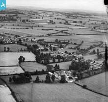
EPW022428 ENGLAND (1928). Butler's Court and Downington, Lechlade on Thames, from the north-west, 1928

© Hawlfraint cyfranwyr OpenStreetMap a thrwyddedwyd gan yr OpenStreetMap Foundation. 2026. Trwyddedir y gartograffeg fel CC BY-SA.
Manylion
| Pennawd | [EPW022428] Butler's Court and Downington, Lechlade on Thames, from the north-west, 1928 |
| Cyfeirnod | EPW022428 |
| Dyddiad | August-1928 |
| Dolen | |
| Enw lle | LECHLADE ON THAMES |
| Plwyf | LECHLADE |
| Ardal | |
| Gwlad | ENGLAND |
| Dwyreiniad / Gogleddiad | 420736, 199994 |
| Hydred / Lledred | -1.699935171994, 51.697848685341 |
| Cyfeirnod Grid Cenedlaethol | SU2071000 |
Pinnau

Eagle eye |
Sunday 22nd of February 2015 09:13:31 PM | |
|
Eagle eye |
Saturday 7th of February 2015 09:04:57 PM | |
Lynda Tubbs |
Tuesday 28th of January 2014 03:27:24 PM | |
Lynda Tubbs |
Thursday 31st of January 2013 10:12:36 AM | |
Lynda Tubbs |
Thursday 31st of January 2013 10:11:47 AM |
Cyfraniadau Grŵp
The strip of trees halfway up the photograph on the left hand side must be the cemetery, with the path leading to the A417. The earliest graves date back to the 1920s I believe. |
Lynda Tubbs |
Thursday 31st of January 2013 10:08:58 AM |
The farm in the foreground is Butlers Court Farm. I think that only the house and a couple of barns remain. When were the other buildings cleared? |
Lynda Tubbs |
Tuesday 29th of January 2013 11:24:37 PM |
Butler's Court and Downington, Lechlade on Thames, from the north-west, 1928 |
Hefin Meara |
Tuesday 22nd of January 2013 11:19:47 AM |